An official website of the United States government
Here's how you know
Official websites use .gov
A .gov website belongs to an official government organization in the United States.
Secure .gov websites use HTTPS
A lock () or https:// means you’ve safely connected to the .gov website. Share sensitive information only on official, secure websites.
Scientists continue to monitor the ongoing eruption in Kīlauea Volcano's summit caldera, Island of Hawai‘i. Fountaining continues at two locations, more vigorously at northern (eastern) vent and intermittent at western vent; both vents continue to feed the growing lava lake.
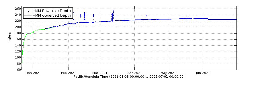
You can now track rise of the lava lake in Halema‘uma‘u at Kīlauea Volcano's summit. The chart below will be updated with observations from the field. Check it here: https://www.usgs.gov/volcanoes/kilauea/current-eruption
Graph showing the depth of the Halema‘uma‘u crater lava lake at Kīlauea Volcano's summit. HVO scientists measure the Kīlauea summit lava level using a small laser rangefinder mounted on a tripod. Measurements began one day after the start of the eruption on December 20, 2020 and are updated by geologists making observations from the field.
HVO field crews continue to monitor Kīlauea's summit eruption. As of just after 7 a.m. HST this morning (Dec. 24), HVO field crews noted that the Kīlauea summit lava lake surface is now 452 m (1483 ft) below the crater rim observation site, indicating that the lake has filled 169 m (554 ft) of the bottom of Halema‘uma‘u crater. This compares to a measurement aroun 8 a.m. HST on Dec 23, when the lake surface was 464 m (1522 ft) below the crater rim observation site, indicating that the lake rose 12 m (39 ft) in just under 24 hours. Fountaining continues at two locations, more vigorously at northern (eastern) vent and intermittent at western vent; both vents continue to feed the growing lava lake. USGS photo by F. Trusdell.
Kīlauea summit KW webcam has captured the recent changes to the summit. The first image, taken on December 20, 2020, just before 6 p.m. HST shows the water lake that was present until Sunday evening. At 9:30 p.m. on December 20, an eruption began in the walls of Halemaʻumaʻu crater, vaporizing the lake. The second image, taken December 24, 2020, just after 6:30 a.m. HST shows that the water lake has been replaced by a lava lake; fissures in the wall of Halemaʻumaʻu feed a lava lake that continues to fill the crater. You can view live KW webcam images here. USGS photo.
This photo was taken yesterday, December 23, from the south rim of Halema`uma`u and shows the island near the center of the lava lake. The island, which has been rafted around the surface, has a much different color and texture than the surrounding lava lake surface. USGS photo taken by M. Patrick.
A photo from the south rim of Halema`uma`u shows a close-up view of the islands margin, where it abuts the fresh lava on the lake surface. Unlike the surrounding lava lake surface, the island appears to be composed of fragments of ejecta and may have originated from violent lava/water interactions in the opening hours of the eruption when the lake was boiled off. USGS photo taken by M. Patrick on December 23.
Beginning on December 20, 2020, fissure vents opened in the Halema‘uma‘u crater. The former water lake quickly boiled away and, fed by two active fissures, the new lava lake is rising. How high is the lava in the approximately 54 acre lake? If the Empire State Building, in New York City, was placed at the bottom of Halema‘uma‘u crater, we estimate the lava lake level could already be as high as the 44th floor! USGS graphic by Joe Bard.
23 December 2020 - Kīlauea Volcano US Geological Survey Hawaiian Volcano Observatory. Clip 1: A mid-day helicopter overflight provided aerial views of the eruption in Halema'uma'u crater. This video shows two active fissures erupting lava into a growing lava lake. Visual and thermal images collected during the overflight are used to map the ongoing activity. Clip 2: Three small spattering vents on the western fissure, taken from the south rim of at 9 a.m. HST. Clip 3: Fountaining from the north fissure, taken from the south rim at 9 a.m. HST.
This thermal timelapse shows the switch from water lake to lava lake in Halema‘uma‘u, spanning December 20 to December 24. During the initial phase of lava appearing in the crater, a large steam plume is generated as lava interacts with and boils off the water lake. The temperature scale in this initial phase is saturated, but the camera settings were later changed to accommodate the much higher temperatures of the new lava in the crater. The sequence also shows the early evolution of a lava lake - a process rarely observed in detail. An island formed at the bottom of the crater in the initial stages is rafted up by the new lava, and continues to drift in the lake currents today. As the lava fills the crater, it has approached the level of the main fountaining vent, which could soon be submerged. Temperature scale is in degrees Celsius.
The Kīlauea summit eruption within Halema‘uma‘u crater continues. As of this afternoon, December 24, the lava lake continues to rise and is covering the lower section of the main northern fissure (center). The western fissure (left) is weakly spattering and a small skylight suggests that the narrow lava channel may have tubed over and is entering into the lava lake out of sight. USGS photo taken by H. Dietterich.
Hawaiian Volcano Observatory scientists monitoring the fissures and lava lake from the rim of Halema‘uma‘u crater. Field crews make observations including changes in the ongoing activity, measurements of the lava lake level, and visual and thermal camera (pictured) documentation. USGS photo taken by H. Dietterich on December 24.