U.S. flag

An official website of the United States government

November 18, 2021

A new eruption at Kīlauea's summit began at approximately 3:20 p.m. HST on September 29, 2021. Lava activity is currently confined within Halema‘uma‘u crater, in the closed area of Hawai‘i Volcanoes National Park. 

HVO scientists collect detailed data to assess hazards and understand how the eruption is evolving at Kīlauea's summit, all of which are shared with the National Park Service and emergency managers. Access to this hazardous area is by permission from, and in coordination with, Hawai‘i Volcanoes National Park.

Color photograph of volcanic vent
A telephoto view of the west vent along the western wall of Halema‘uma‘u crater at the summit of Kīlauea. On November 9, spatter bursts in the west vent cone triggered sloshing on the surface of the ponded lava. Spatter was thrown about 6–9 m (20–30 ft) above the pond surface and occasionally deposited onto the rim of the cone. USGS photo by J. Schmith.
Lava continues to erupt from the west vent in Halema‘uma‘u, and supply the lava lake through a spillway in the spatter cone. On November 12, a small overflow of the perched lava lake levee was visible from the western crater rim. Overflows are an important process for building up perched levees, as they help add height and stability. The height of the levee in this video was measured at 1 m (3.3 ft). 
Color photograph of a brown-gray volcanic landscape dominated by tephra and older lava flows
During a helicopter overflight of Kīlauea summit on the morning of November 16, 2021, this aerial view (looking southwest) of the lava flow erupted in September 1982 was captured. The September 1982 lava flow exited Kīlauea summit caldera through a narrow gap, visible near the center of the photo. The narrow lava flow, which is a reflective black color in the photo, then flowed southwest over a portion of the September 1971 Kīlauea lava flow (the duller black lava flow visible in the center right part of the photo). In the background of the photo, the Koa‘e Fault Zone is seen as a series of mostly parallel lines disrupting the landscape in the distance. USGS photo by N. Deligne.
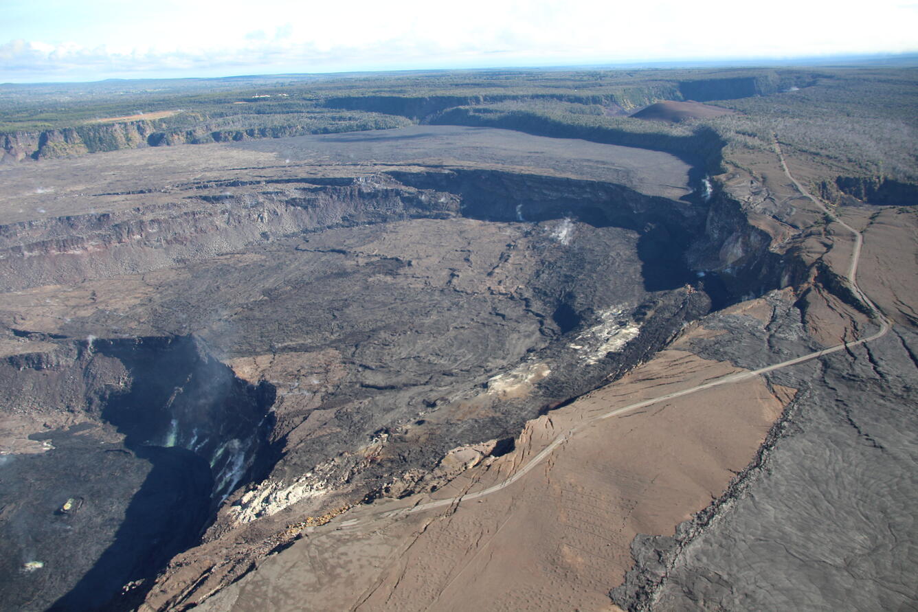
Color photo of Kilauea caldera showing the down-dropped blocks that formed during the 2018 caldera collapse
Aerial view looking northeast of the eastern half of the Kīlauea summit caldera, taken during a helicopter overflight of the Kīlauea summit on the morning of November 16, 2021. The current lava lake in Halema‘uma‘u is visible in bottom left, and scarps associated with 2018 Kīlauea summit collapse are prominent in the center of the photo. Crater Rim Drive (closed to vehicles, with limited public access), damaged and destroyed in places in 2018, is visible in the left and bottom portions of the photo. Part of the September 1982 lava flow is visible in lower right part of the photo, and Keanakāko‘i Crater is visible on the right side of the photo, about a third of the way from the top. Pu‘u Pua‘i is the brown hill visible in the top left part of the photo, with Kīlauea Iki Crater just barely visible behind it. USGS photo by N. Deligne.

Get Our News

These items are in the RSS feed format (Really Simple Syndication) based on categories such as topics, locations, and more. You can install and RSS reader browser extension, software, or use a third-party service to receive immediate news updates depending on the feed that you have added. If you click the feed links below, they may look strange because they are simply XML code. An RSS reader can easily read this code and push out a notification to you when something new is posted to our site.