An official website of the United States government
Here's how you know
Official websites use .gov
A .gov website belongs to an official government organization in the United States.
Secure .gov websites use HTTPS
A lock () or https:// means you’ve safely connected to the .gov website. Share sensitive information only on official, secure websites.
A new eruption at Kīlauea's summit began at approximately 3:20 p.m. HST on September 29, 2021. Lava activity is currently confined within Halema'uma'u crater. Gas emissions and seismic activity at the summit remain elevated. HVO field crews—equipped with specialized safety gear—monitor the eruption from within the closed area of Hawai‘i V
HVO scientists collect detailed data to assess hazards and understand how the eruption is evolving at Kīlauea's summit, all of which are shared with the National Park Service and emergency managers. Access to this hazardous area is by permission from, and in coordination with, Hawai‘i Volcanoes National Park.
The USGS Hawaiian Volcano Observatory KWcam at Kīlauea's summit has captured changes within Halemaʻumaʻu crater, at Kīlauea's summit, due to the eruption that began on September 29, 2021. At approximately 3:21 pm, HST, new fissures opened at the base of Halemaʻumaʻu crater. These fissures opened east of the large island near the center of the lava lake that was active within Halemaʻumaʻu crater from December 2020 until May 2021. The first image was taken on September 29, 2021, just before the eruption began; the second image was taken the morning of October 4, 2021, just before 6 a.m. HST and shows the continuing eruption and growing lava lake. Near-real-time images captured by the KWcam are available here: https://www.usgs.gov/volcanoes/kilauea/kwcam-live-panorama-halema-uma-u-.... USGS webcam images.
This zoomed-in view of the erupting western fissure in Halema‘uma‘u shows lava fountaining activity on the morning of October 4, 2021. The fountains have built a C-shaped spatter rampart around their source, which is now submerged in the rising lava lake. Using a laser rangefinder, HVO field crews measured the spatter rampart to be standing 20 m (66 ft) above the surrounding lava lake surface. USGS photo by M. Zoeller.
This photo, captured on the morning of October 4, 2021, provides a zoomed-in view of the eastern edge of the main island in the Halema‘uma‘u lava lake. In the earliest days of the ongoing Kīlauea eruption, this was the site of an energetic eruptive vent that showered the island with spatter and tephra. Activity had waned substantially, but not completely: volcanic gases continue to be emitted (center left), and spreading textures on the surface of the lava lake (center) indicate continued slow effusion of lava at this site. USGS photo by M. Zoeller.
A telephoto view of the lava fountain in the western wall of Halema‘uma‘u crater during Kīlauea's ongoing summit eruption. In the late afternoon on Sunday, October 3, the maximum fountain height was measured at approximately 11 meters (36 ft). This photo was taken from the south rim of Halema‘uma‘u looking to the west around 4:00 p.m. HST. Hawaiian Volcano Observatory scientists continue to monitor the eruption from an area within Hawai‘i Volcanoes National Park that remains closed to the public due to safety reasons. USGS photo taken by K. Lynn.
On Sunday, October 3, 2021, the late afternoon sunlight illuminated a perched edge of the active lava lake within Halema‘uma‘u, at Kīlauea summit. This view, looking to the northeast from the south rim of Halema‘uma‘u, shows the active lake surface (left) that is elevated a few meters (yards) above the lower trough along the crater wall (right). Overflows of the levee—such as the one seen in the top center of this photo—fill in sections of the trough with lava and shallow the elevation difference from the active lake surface until the levee begins to build again. USGS photo taken by K. Lynn.
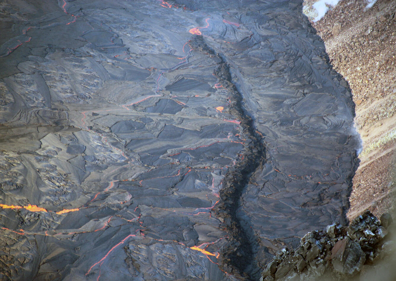
A telephoto view of foundering in the active lava lake within Halema‘uma‘u crater, at the summit of Kīlauea. Foundering occurs when denser and cooler solidified crust (black) sinks below less dense liquid lava (orange). Photo taken at 7:48 a.m. HST on October 4, 2021. USGS photo by J.M. Chang.