
Tuffisite veins form during eruptions, when a mix of hot volcanic gas and rock fragments are forced through fractures in cooled lava. USGS photo by J. Crozier.
Images
Images related to Mono-Inyo Craters.

Panum Crater tuffisite
Tuffisite veins form during eruptions, when a mix of hot volcanic gas and rock fragments are forced through fractures in cooled lava. USGS photo by J. Crozier.

Rhyolite lava domes of the Mono Craters
Mono Craters consists of a series of high-silica rhyolite lava domes, many erupted within the last 10,000 years. The domes are often steep, glassy, and contain very few phenocrysts.
Mono Craters consists of a series of high-silica rhyolite lava domes, many erupted within the last 10,000 years. The domes are often steep, glassy, and contain very few phenocrysts.

Model of reservoirs underneath Long Valley Caldera
Model of reservoirs underneath Long Valley CalderaMain hydrothermal features of the new (2016) 3-D model of the subsurface at Long Valley Caldera. This schematic is based on a survey of the electrical properties of the earth (magnetotellurics) below. Arrows show subsurface water flow, with colors keyed to changing water temperature, from blue (cold) to red (hot). Purple arrows show an extinct hot water pathway.

Long Valley Caldera range-front faults terminate at the caldera bou...
Long Valley Caldera range-front faults terminate at the caldera bou...This is a simplified diagram of regional range front faults as they intersect the Long Valley Caldera.
Long Valley Caldera range-front faults terminate at the caldera bou...
Long Valley Caldera range-front faults terminate at the caldera bou...This is a simplified diagram of regional range front faults as they intersect the Long Valley Caldera.

Conceptual geologic model of partially crystallized magma (C1, C3) ...
Conceptual geologic model of partially crystallized magma (C1, C3) ...C1 and C3 are granitic crystal-melt mush (partially crystallized magma) columns that fed the most recent Mono Craters eruptions. The connection from C1 to South Coulée (SC) is older and colder than the connection from C3 to North Coulée (NC) and Panum Crater (PC), which carries hydrothermal fluid to the surface.

Hydrothermal system and water flow in the subsurface beneath Long V...
Hydrothermal system and water flow in the subsurface beneath Long V...Hydrothermal system and water flow in the subsurface beneath Long Valley Caldera, California. Cartoon Illustration from USGS FS 2007-3045.
Hydrothermal system and water flow in the subsurface beneath Long V...
Hydrothermal system and water flow in the subsurface beneath Long V...Hydrothermal system and water flow in the subsurface beneath Long Valley Caldera, California. Cartoon Illustration from USGS FS 2007-3045.

Map of volcanic ash fall as a result of eruptions from Yellowstone,...
Map of volcanic ash fall as a result of eruptions from Yellowstone,...Map of volcanic ashfall. Areas of the United States that once were covered by volcanic ash from Yellowstone's giant eruptions 2 million and 630,000 years ago, compared with ashfall from the 760,000-year-old Long Valley caldera eruptions at Mammoth Lakes, California, and the 1980 eruption of Mount St. Helens, Washington.

View of the Mono Lake-Long Valley volcanic region
An aerial view looking south of the Long Valley volcanic region in the area of Mono Lake, showing a line of rhyolite lava domes and explosion craters. An inset map shows the locations of silcic magmatic centers in the Long Valley area.
An aerial view looking south of the Long Valley volcanic region in the area of Mono Lake, showing a line of rhyolite lava domes and explosion craters. An inset map shows the locations of silcic magmatic centers in the Long Valley area.
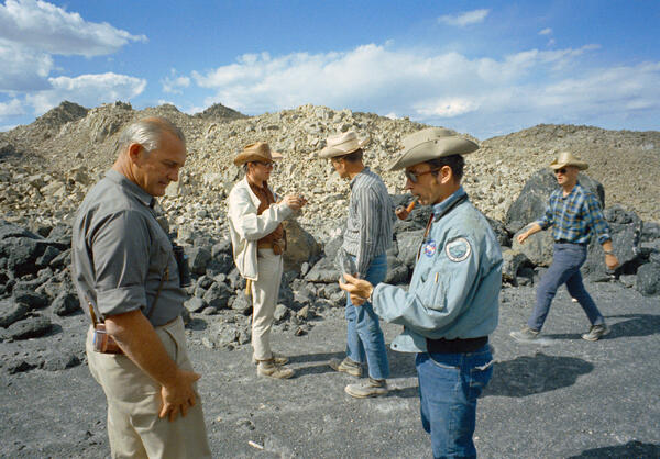
Apollo 16 astronauts on a geology field trip to Mono Craters, California in June 1971.
Apollo 16 astronauts on a geology field trip to Mono Craters, California in June 1971.University of Texas professor William R. Muelhberger (left foreground) with Apollo 16 commander John W. Young (right foreground), astronaut Charles Duke (center), geologist David Wones (second left), and astronaut Anthony England on an Apollo 16 geology field trip to Mono Craters in June 1971. Photo by NASA.