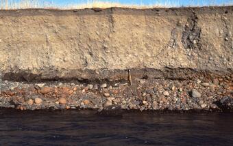
Lahars from Mount Adams threaten the White Salmon River valley and, secondarily, the Klickitat River canyon.

Lahars from Mount Adams threaten the White Salmon River valley and, secondarily, the Klickitat River canyon. Geophysical studies have detected a large area (up to 1.3 billion cubic meters or 46 billion cubic feet) of hydrothermally altered and weakened rock in the southwest sector of the upper cone. This material will continue to spawn landslides and debris avalanches, and if a large failure occurs, lahars almost certainly will follow. Lahars from this sector will flow down the White Salmon River, where the towns of Trout Lake, BZ Corner, and Husum are located in the hazard zone. A much smaller volume (12.5 million cubic meters or 440 million cubic feet) has been determined to compose a steep area on the upper east flank of Mount Adams above the Klickitat River canyon. Given the smaller volume of altered rock there and the longer distances to downstream communities, the risk to downstream communities along the Klickitat River is lower.

Lahars that either reach the Columbia River or add increased amounts of sediment load in the river's tributaries could clog the Columbia River shipping channel, an important transportation link for the region's agricultural economy. The annual probability of a future lahar large enough to affect the Trout Lake area (small town and farming area) is estimated to be 0.1 to 1 percent; for a potentially catastrophic lahar the size of the Trout Lake lahar that occurred 6,000 years ago, it is 0.01 to 0.1 percent.
Lahars from Mount Adams threaten the White Salmon River valley and, secondarily, the Klickitat River canyon.

Lahars from Mount Adams threaten the White Salmon River valley and, secondarily, the Klickitat River canyon. Geophysical studies have detected a large area (up to 1.3 billion cubic meters or 46 billion cubic feet) of hydrothermally altered and weakened rock in the southwest sector of the upper cone. This material will continue to spawn landslides and debris avalanches, and if a large failure occurs, lahars almost certainly will follow. Lahars from this sector will flow down the White Salmon River, where the towns of Trout Lake, BZ Corner, and Husum are located in the hazard zone. A much smaller volume (12.5 million cubic meters or 440 million cubic feet) has been determined to compose a steep area on the upper east flank of Mount Adams above the Klickitat River canyon. Given the smaller volume of altered rock there and the longer distances to downstream communities, the risk to downstream communities along the Klickitat River is lower.

Lahars that either reach the Columbia River or add increased amounts of sediment load in the river's tributaries could clog the Columbia River shipping channel, an important transportation link for the region's agricultural economy. The annual probability of a future lahar large enough to affect the Trout Lake area (small town and farming area) is estimated to be 0.1 to 1 percent; for a potentially catastrophic lahar the size of the Trout Lake lahar that occurred 6,000 years ago, it is 0.01 to 0.1 percent.

