
Ash Cloud Simulations - What if Mount St. Helens Produced an Explosive Eruption Today?
When a volcano erupts explosively, an ash cloud will be produced. Its size and travel-distance are determined by the amount of material erupted, the height of the cloud, plus the wind directions and speeds. Knowing where the ash cloud might travel is critical for managing air space and warning downwind communities to be ready for possible ash fall.
The following three Ash3D computer simulations, developed by the USGS, use current wind speed and directional data from the National Oceanic and Atmospheric Administration along with eruption size parameters set by volcanologists to model the potential path of an ash cloud if an eruption were to occur from Mount St. Helens today. This does not mean an eruption has occurred. Read the CVO activity update for information on current volcanic conditions.
What is the simulated ash-cloud path if an explosive eruption were to occur from Mount St. Helens today?
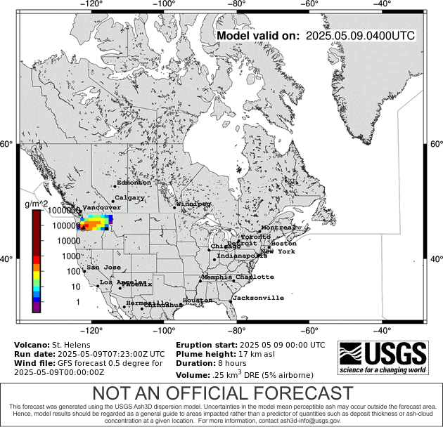
For a relatively large eruption similar in size to Mount St. Helens, May 18, 1980:
For a relatively moderate eruption similar in size to Mount Spurr, Alaska, August 18, 1992:
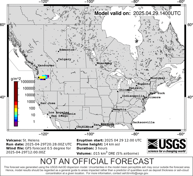
For a relatively small eruption similar in size to Mount St. Helens, July 22, 1980:
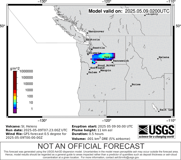
What do these graphics show?
- The graphics show the expected amount of ash in the atmosphere should an eruption occur similar in size to what is indicated.
- Colors represent expected amounts of ash in the atmosphere from the ground to the top of the cloud. Warmer colors represent areas of greater ash. Colder colors mean less ash.
- USGS scientists run this model to prepare for possible eruptions. It DOES NOT mean an ash cloud has been produced. Official ash cloud warnings will be released by the NOAA National Weather Service. See current status for Mount St. Helens.
- This model DOES NOT show ash fallout. Note that it is possible for ash clouds to move overhead and produce little or no ash fall.
- For more information about Ash3D, see USGS Open-File Report 2013-1122.
How can you be prepared for ash hazards?
Read about the hazards and impacts associated with ash fall. To be prepared for potential ash fall, read about our guidelines for a safety plan and survival kit. During an eruption, stay informed by listening to emergency broadcasts. You may be asked to stay sheltered in place until the ash fall is over.
When a volcano erupts explosively, an ash cloud will be produced. Its size and travel-distance are determined by the amount of material erupted, the height of the cloud, plus the wind directions and speeds. Knowing where the ash cloud might travel is critical for managing air space and warning downwind communities to be ready for possible ash fall.
The following three Ash3D computer simulations, developed by the USGS, use current wind speed and directional data from the National Oceanic and Atmospheric Administration along with eruption size parameters set by volcanologists to model the potential path of an ash cloud if an eruption were to occur from Mount St. Helens today. This does not mean an eruption has occurred. Read the CVO activity update for information on current volcanic conditions.
What is the simulated ash-cloud path if an explosive eruption were to occur from Mount St. Helens today?
For a relatively large eruption similar in size to Mount St. Helens, May 18, 1980:
For a relatively moderate eruption similar in size to Mount Spurr, Alaska, August 18, 1992:
For a relatively small eruption similar in size to Mount St. Helens, July 22, 1980:
What do these graphics show?
- The graphics show the expected amount of ash in the atmosphere should an eruption occur similar in size to what is indicated.
- Colors represent expected amounts of ash in the atmosphere from the ground to the top of the cloud. Warmer colors represent areas of greater ash. Colder colors mean less ash.
- USGS scientists run this model to prepare for possible eruptions. It DOES NOT mean an ash cloud has been produced. Official ash cloud warnings will be released by the NOAA National Weather Service. See current status for Mount St. Helens.
- This model DOES NOT show ash fallout. Note that it is possible for ash clouds to move overhead and produce little or no ash fall.
- For more information about Ash3D, see USGS Open-File Report 2013-1122.
How can you be prepared for ash hazards?
Read about the hazards and impacts associated with ash fall. To be prepared for potential ash fall, read about our guidelines for a safety plan and survival kit. During an eruption, stay informed by listening to emergency broadcasts. You may be asked to stay sheltered in place until the ash fall is over.