
A modern illustration of each state's landscape uses 3DEP data to showcase subtle beauty in their elevation differences like never before. Every state has been consistently adjusted and colorized using the seamless 3DEP 1/3rd arc-second data according to its highest and lowest elevations, which helps accentuate differences even in states with low relief.
Multimedia
Multimedia includes lidar related graphics and videos and science reporting. All items in this gallery are considered public domain unless otherwise noted. Lidar data uses from the community of users may be found on our 3DEP Uses in the News page.
Images
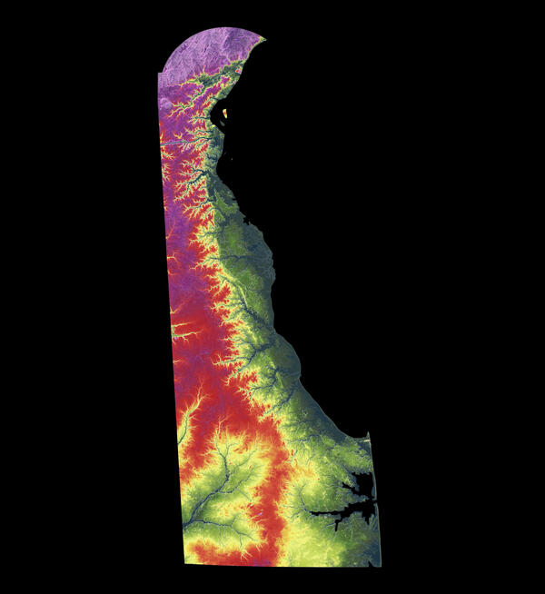
3DEP As Art - Delaware
A modern illustration of each state's landscape uses 3DEP data to showcase subtle beauty in their elevation differences like never before. Every state has been consistently adjusted and colorized using the seamless 3DEP 1/3rd arc-second data according to its highest and lowest elevations, which helps accentuate differences even in states with low relief.
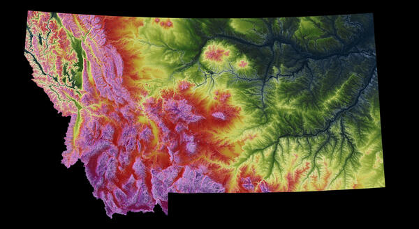
3DEP As Art - Montana
A modern illustration of each state's landscape uses 3DEP data to showcase subtle beauty in their elevation differences like never before. Every state has been consistently adjusted and colorized using the seamless 3DEP 1/3rd arc-second data according to its highest and lowest elevations, which helps accentuate differences even in states with low relief.
A modern illustration of each state's landscape uses 3DEP data to showcase subtle beauty in their elevation differences like never before. Every state has been consistently adjusted and colorized using the seamless 3DEP 1/3rd arc-second data according to its highest and lowest elevations, which helps accentuate differences even in states with low relief.
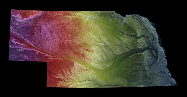
3DEP As Art - Nebraska
A modern illustration of each state's landscape uses 3DEP data to showcase subtle beauty in their elevation differences like never before. Every state has been consistently adjusted and colorized using the seamless 3DEP 1/3rd arc-second data according to its highest and lowest elevations, which helps accentuate differences even in states with low relief.
A modern illustration of each state's landscape uses 3DEP data to showcase subtle beauty in their elevation differences like never before. Every state has been consistently adjusted and colorized using the seamless 3DEP 1/3rd arc-second data according to its highest and lowest elevations, which helps accentuate differences even in states with low relief.
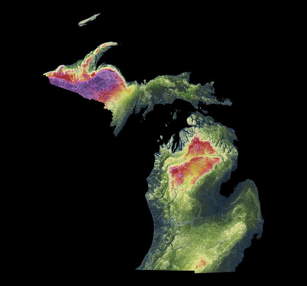
3DEP As Art - Michigan
A modern illustration of each state's landscape uses 3DEP data to showcase subtle beauty in their elevation differences like never before. Every state has been consistently adjusted and colorized using the seamless 3DEP 1/3rd arc-second data according to its highest and lowest elevations, which helps accentuate differences even in states with low relief.
A modern illustration of each state's landscape uses 3DEP data to showcase subtle beauty in their elevation differences like never before. Every state has been consistently adjusted and colorized using the seamless 3DEP 1/3rd arc-second data according to its highest and lowest elevations, which helps accentuate differences even in states with low relief.
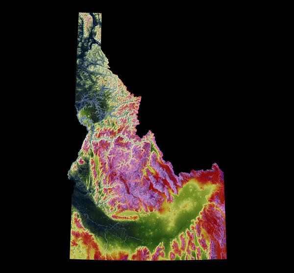
3DEP As Art - Idaho
A modern illustration of each state's landscape uses 3DEP data to showcase subtle beauty in their elevation differences like never before. Every state has been consistently adjusted and colorized using the seamless 3DEP 1/3rd arc-second data according to its highest and lowest elevations, which helps accentuate differences even in states with low relief.
A modern illustration of each state's landscape uses 3DEP data to showcase subtle beauty in their elevation differences like never before. Every state has been consistently adjusted and colorized using the seamless 3DEP 1/3rd arc-second data according to its highest and lowest elevations, which helps accentuate differences even in states with low relief.
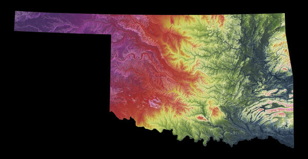
3DEP As Art - Oklahoma
A modern illustration of each state's landscape uses 3DEP data to showcase subtle beauty in their elevation differences like never before. Every state has been consistently adjusted and colorized using the seamless 3DEP 1/3rd arc-second data according to its highest and lowest elevations, which helps accentuate differences even in states with low relief.
A modern illustration of each state's landscape uses 3DEP data to showcase subtle beauty in their elevation differences like never before. Every state has been consistently adjusted and colorized using the seamless 3DEP 1/3rd arc-second data according to its highest and lowest elevations, which helps accentuate differences even in states with low relief.
Videos

National Tribal Webinar on the USGS 3D Elevation Program and 3D Hydrography Program
National Tribal Webinar on the USGS 3D Elevation Program and 3D Hydrography ProgramThis video summarizes the 3DEP and 3DHP programs for a Tribal audience, providing an overview of the program and its goals and methods. The presentation includes information about topics of possible concern to Tribes, and points of contact to address questions and concerns.

December 16, 2025 USGS Hydrography Community Call
The topic will be “3DHP Overview and Status – FY25 Accomplishments and FY26 Plans”
Presenter is Steve Aichele, National Geospatial Program Hydrography Planning and Management Lead
The topic will be “3DHP Overview and Status – FY25 Accomplishments and FY26 Plans”
Presenter is Steve Aichele, National Geospatial Program Hydrography Planning and Management Lead

2024 Overview of the USGS 3D Elevation Program and 3D Hydrography Program for Tribes
2024 Overview of the USGS 3D Elevation Program and 3D Hydrography Program for TribesUSGS invited all federally recognized Tribes, Alaska Native Corporations, and Native Hawaiian Organizations to virtual informational meetings on March 11, 2024 and March 22, 2024 about the 3D National Topography Model and its components, the 3D Elevation Program and the 3D Hydrography Program.

USACE Huntington Use of USGS Data and Services
The US Army Corps of Engineers (USACE) office in Huntington, WV provides a number of floodplain management services. These include base flood elevation (BFE) evaluations, watershed modeling, project planning, and responding to numerous technical questions.
The US Army Corps of Engineers (USACE) office in Huntington, WV provides a number of floodplain management services. These include base flood elevation (BFE) evaluations, watershed modeling, project planning, and responding to numerous technical questions.