



3DNTM By The Numbers
USGS aligns and integrates elevation data from the 3D Elevation Program (3DEP) and hydrography data from the 3D Hydrography Program (3DHP) under the umbrella of the 3D National Topography Model (3DNTM).
3DEP and 3DHP are based on community-wide partner investments
The USGS was designated in 2002 by the Office of Management and Budget (through OMB Circular A–16) as the lead Federal agency for inland waters and terrestrial elevation data. 3DEP and 3DHP are designed to fulfill that leadership responsibility and to ensure that the needs of the Nation for high-quality 3D elevation data and 3D hydrography are being met. This role cannot be filled by the USGS alone. The programs are a collaborative effort that include many partners, such as Federal agencies and State, Tribal, and local governments, who are working together to update and improve the national collection of 3D elevation and 3D hydrography data. Private sector firms, under contract to the Government, are collecting the data and providing essential technology solutions to manage and deliver these data and services.
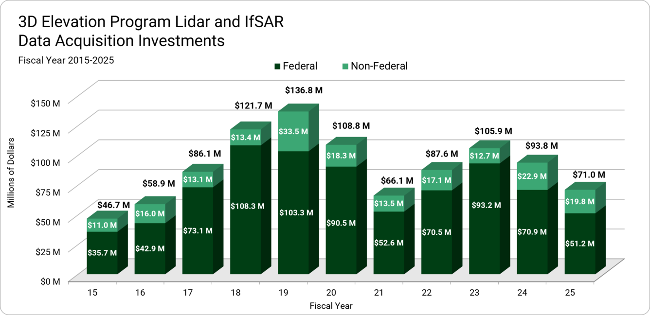
Progress towards the goal of a complete nationwide baseline 3DEP dataset and acquiring updated, higher quality data more frequently is due in large part to community-wide partner investments. From fiscal year (FY) FY15 - FY25, USGS funded 33.1% of 3DEP costs for data acquisition and data processing and management, while the community-wide partners funded 60% for data acquisition, with the remaining 7% of funding coming from disaster supplemental appropriations. The information below summarizes community-wide partner 3DEP expenditures from FY15 – FY25.
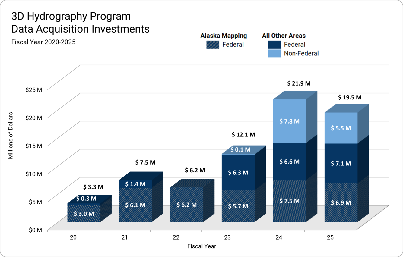
The 3DHP represents the first systematic remapping of the Nation’s hydrography since the original USGS 1:24,000-scale topographic mapping program was active. As with 3DEP, successful implementation of the 3DHP relies on community-wide partner investments. Collection of elevation-derived hydrography (EDH) for the 3DHP began in Alaska in 2020 and several EDH projects were initiated in the conterminous United States (CONUS) between 2020 and 2023. Activities associated with maintaining the legacy NHD continued into FY23, with those resources directed to the 3DHP in FY24, which was the first full year of the 3DHP. From FY 20-24, USGS funded 24% of 3DHP costs for CONUS data acquisition and data processing and management, while the community-wide partners funded 76% for data acquisition. USGS has funded 92% of data acquisition and data validation costs in Alaska with federal partners funding the remaining 8%.
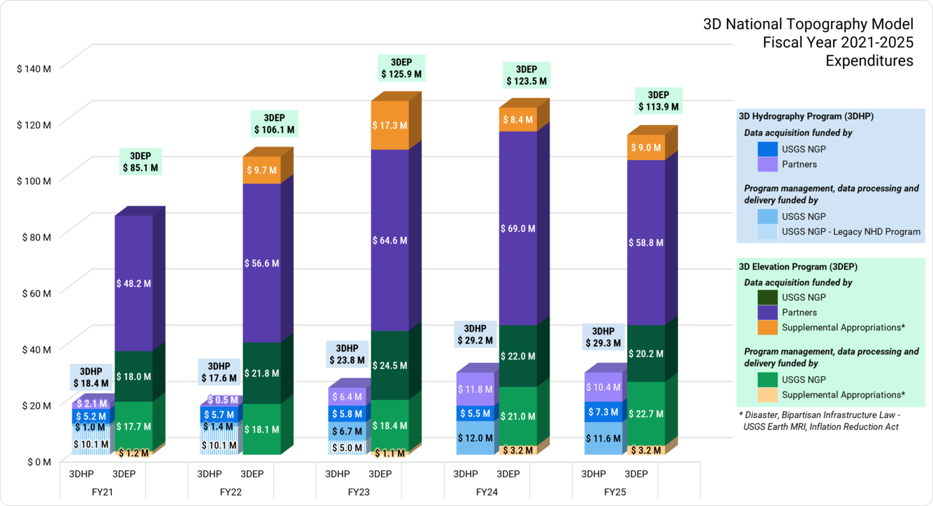
Note: 3DEP supplemental funding includes hurricane and wildfire disaster supplemental funds, Bipartisan Infrastructure Law funds, and Inflation Reduction Act funds. The chart shows the funding by year obligated. The USGS funding for 3DHP and 3DEP is part of the Core Science Systems - National Geospatial Program line item funded by the FY25 appropriations at \$89.650 million. The National Geospatial Program line-item funds 3DEP, 3DHP, US Topo, The National Map viewer, and other components of the National Map.