An official website of the United States government
Here's how you know
Official websites use .gov
A .gov website belongs to an official government organization in the United States.
Secure .gov websites use HTTPS
A lock () or https:// means you’ve safely connected to the .gov website. Share sensitive information only on official, secure websites.
View of the fissure 8 cone and spillway from HVO's overflight early this morning, during which geologists observed eruptive activity that was much less vigorous than in past days.
Looking more directly into the fissure 8 vent this morning, the inner walls of the cone and lava surface could be seen. The level of lava within the vent and spillway (left) were down compared to yesterday. A dark crust, which forms as the lava surface cools, had formed on the lava with the spillway.
Incandescent lava remained visible in a section of the fissure 8 channel west of Kapoho Crater (just visible at far left). This view is looking south toward the ocean; the laze plume rising from the ocean entry can be seen in the far distance.
Closer view of the open channel west of Kapoho Crater. According to geologists flying over the area, the flow appeared be the result of draining from the upslope channel; no discernible movement was observed.
A diffuse laze plume afforded a clear view of Isaac Hale Beach Park and the ocean entry, which was being fed across a broad front by viscous pāhoehoe. Lava was oozing laterally, but was still about 70 m (230 ft) southeast of the Pohoiki boat ramp as of this morning.
Another view of Isaac Hale Beach Park and the Pohoiki boat ramp from this morning's overflight. The active ocean entry and laze plume can be seen at lower left.
Here's another "then and now" look at Halema‘uma‘u (view is to north). At left, Halema‘uma‘u, as we once knew it, and the active lava lake within the crater are visible on April 13, 2018. At right is a comparable viewshed captured on July 28, 2018, following recent collapses of the crater. The Hawai‘i Volcanoes National Park Jaggar Museum and USGS-HVO can be seen perched on the caldera rim (middle right) with the slopes of Mauna Loa in the background.
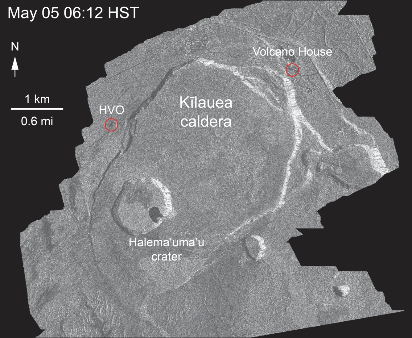
This animated GIF shows a sequence of radar amplitude images that were acquired by the Agenzia Spaziale Italiana CosmoSkyMed satellite system. The images illustrate changes to the caldera area of Kīlauea Volcano that occurred between May 5 and August 5 at about 6:00 a.m. HST. The satellite transmits a radar signal at the surface and measures the strength of the return, with bright areas indicating a strong return and dark areas a weak return. Strong returns indicate rough surfaces or slopes that point back at the radar, while weak returns come from smooth surfaces or slopes angled away from the radar. Over time, expansion of the summit eruptive vent within Halema‘uma‘u crater and the widening of Halema‘uma‘u itself are obvious. Starting in late May, the development of several cracks outside Halema‘uma‘u is clear, and inward slumping of a large portion of the western, southwestern, and northern crater rim begins. Much of this motion appears to be coincident with the small explosions from the summit that have taken place on a near daily basis since early June. The most recent scenes, acquired on August 1, 2, and 5, show little overall motion, which is consistent with the slowing of deformation in the summit area over the past few days.
Get Our News
These items are in the RSS feed format (Really Simple Syndication) based on categories such as topics, locations, and more. You can install and RSS reader browser extension, software, or use a third-party service to receive immediate news updates depending on the feed that you have added. If you click the feed links below, they may look strange because they are simply XML code. An RSS reader can easily read this code and push out a notification to you when something new is posted to our site.