An official website of the United States government
Here's how you know
Official websites use .gov
A .gov website belongs to an official government organization in the United States.
Secure .gov websites use HTTPS
A lock () or https:// means you’ve safely connected to the .gov website. Share sensitive information only on official, secure websites.
Kīlauea's summit eruption continues on the Island of Hawai‘i. HVO field crews—equipped specialized safety gear and PPE—monitor the current eruption from within the closed area of Hawai‘i Volcanoes National Park with NPS permission. The west vent in Halema‘uma‘u remains active; the lava lake level has not changed. Gas
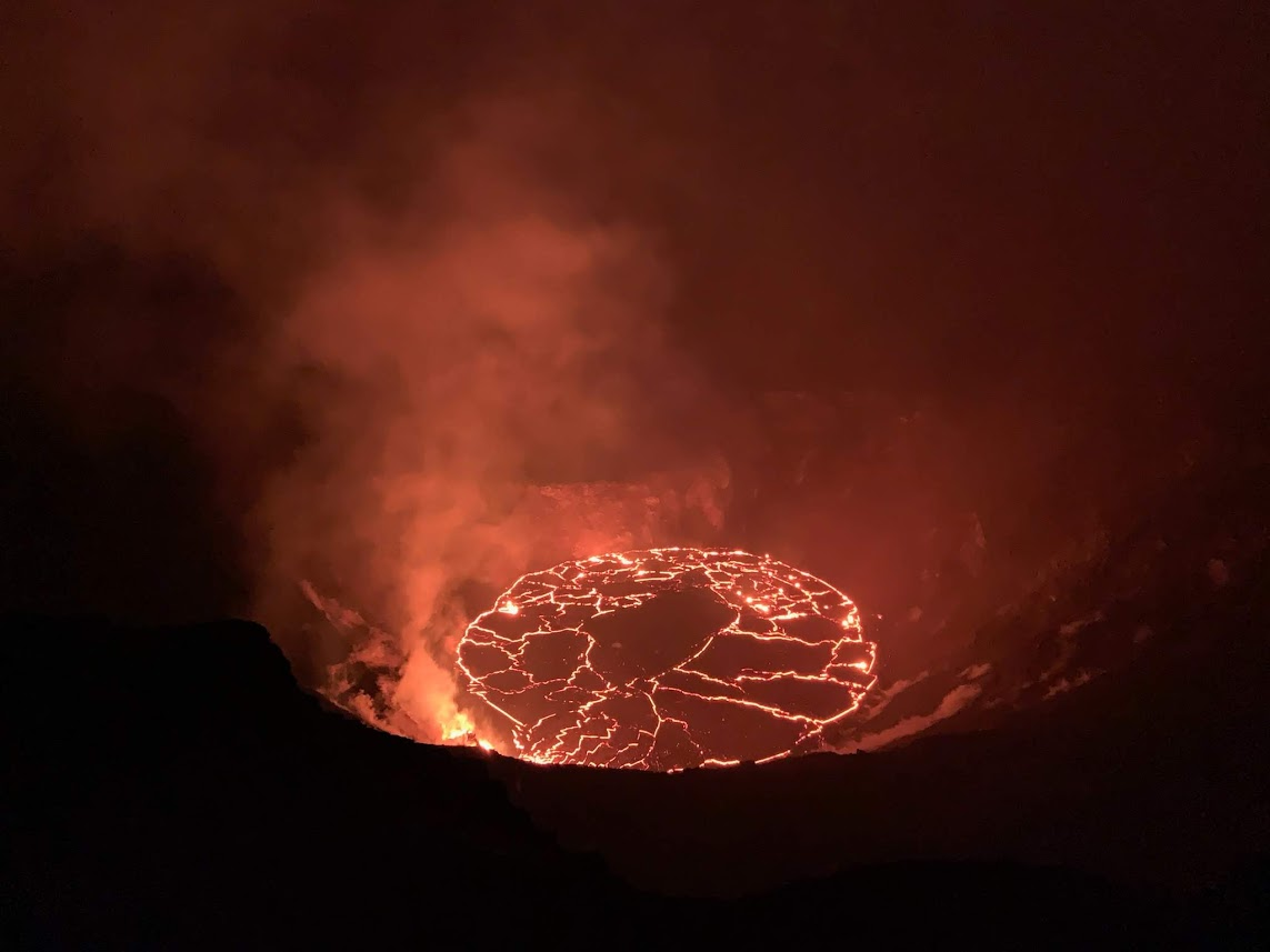
HVO field crews observed the continuing eruption in Halema‘uma‘u at Kīlauea's summit early this morning. Overnight, the western vent in the wall of Halema‘uma‘u continued to erupt, and the northern/eastern vent remained inactive. At approximately 4:30 a.m. HST today (Dec. 28), HVO field crews measured the lava lake as 179 m (586 ft) deep. Note that initial values reported here were incorrect; values reported here were corrected as of 9:30 a.m. HST. USGS photo by D. Downs.
HVO field crews have been using a laser range finder to measure the vertical distance between points of known elevation and features of the ongoing eruption, such as the lava lake surface level and the erupting vents. This morning, the eruption continues at the west vent in Halema‘uma‘u, and streams of lava about 40 m (131 ft) pour from the vent to the lava lake surface. USGS photo by C. Parcheta. (Public domain.)
Sunrise at the summit of Kīlauea, within Hawai‘i Volcanoes National Park, on the morning of December 28, 2020. Portions of Crater Rim Drive that down-dropped during Kīlauea's 2018 collapse events, are visible in the lower left. This area remains closed to the public due to hazardous conditions. USGS photo by C. Parcheta. (Public domain.)
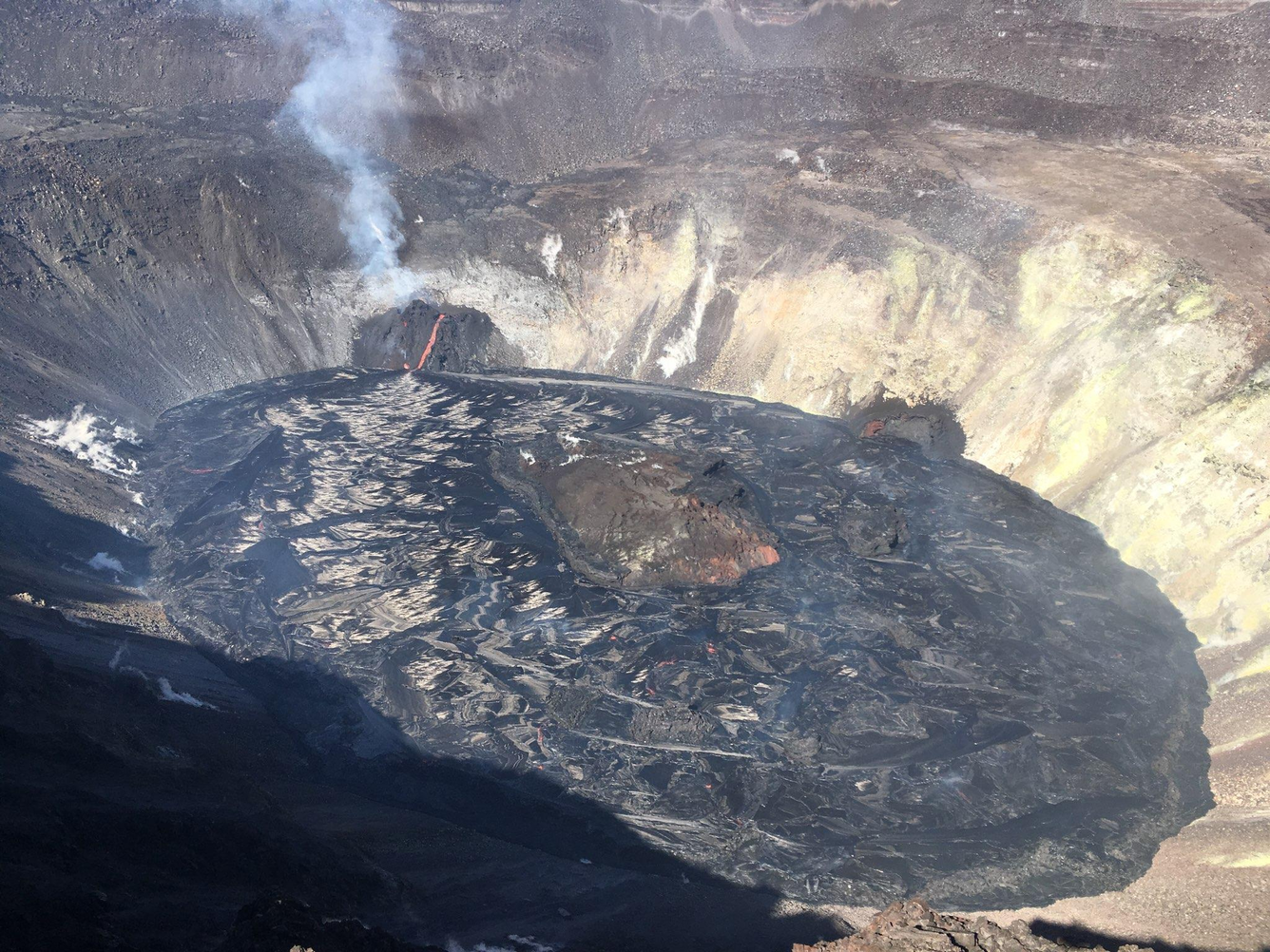
Aerial photograph of Halema‘uma‘u crater, within Kīlauea Volcano, taken from an HVO overflight today (December 28) at approximately 11:00 a.m. HST. There have been no major changes in eruptive activity since this morning and the western vent remains active. The SO2 emissions remain elevated at about 5,500 tonnes/day measured yesterday morning (December 27). USGS photo taken by M. Patrick. (Public domain.)
28 December 2020 - Kīlauea Volcano, US Geological Survey Hawaiian Volcano Observatory - A helicopter overflight this morning (9:30 a.m. HST) provided aerial views of the eruption in Halema‘uma‘u. This video shows the lava lake and active west vent. The spatter rampart built by the northern/eastern vent that is no longer erupting is visible on the crater wall. Visual and thermal imagery collected during the overflight are used to map the ongoing activity. Matt Patrick (Public domain.)
Lava flowing from the western fissure vent feeds multiple channels. This video was taken by Hawaiian Volcano Observatory's geology field team on December 28, 2020, from 2:30 to 5:30 p.m. The team is located at an observation point on the rim of Halema‘uma‘u crater, and is using a telephoto lens to document fissure behavior. During the three-hour period, the field team observed activity at the western fissure vent diminishing in the channel on the right. The channel narrows and the flow becoming more sluggish, pulsing at times. Activity picks up slightly in the lava channel on the left, which is partially covered by a lava roof. During the video, a small whirlpool is visible at the base of the lava channels, in the lava lake. The three-hour video was sped up to play for a duration of 20 seconds. Video by Matt Patrick. (Public domain.)
HVO scientists use a laser rangefinder to measure the distance to the lava lake surface at Kīlauea's summit. By making measurements from a reference point of known elevation, and because the elevation of the base of Halema‘uma‘u before this eruption began was known, scientists can derive the approximate depth of the lava lake which has grown over the past 8 days. In this photo, portions of Crater Rim Drive, which down-dropped during Kīlauea's 2018 summit collapse, are visible between the scientist and the lava lake. USGS photo by M. Patrick at 4:30 p.m. on December 28, 2020.
The eruption with Halema‘uma‘u continues on the evening of December 28, 2020. This photo shows an HVO scientist making observations of Kīlauea's summit lava lake, with Mauna Loa in the background. HVO scientists have been monitoring the eruption from within an area of Hawai‘i Volcanoes National Park that remains closed to the public for safety reasons. No major changes were observed at the eruption site today: the west vent remains active (though slightly diminished in vigor) and continues to feed the lava lake. USGS photo by B. Carr.