An official website of the United States government
Here's how you know
Official websites use .gov
A .gov website belongs to an official government organization in the United States.
Secure .gov websites use HTTPS
A lock () or https:// means you’ve safely connected to the .gov website. Share sensitive information only on official, secure websites.
Kīlauea's summit eruption continues on the Island of Hawai‘i; the west vent in Halema‘uma‘u erupts lava into the lava lake. Gas emissions and seismic activity at the summit remain elevated. HVO field crews—equipped with specialized safety gear and PPE—monitor the current eruption from within the closed area of Hawai&lsq
HVO scientists collect detailed data to assess hazards and understand how the eruption is evolving at Kīlauea's summit, all of which are shared with the National Park Service and emergency managers. Access to this hazardous area is by permission from, and in coordination with, Hawai‘i Volcanoes National Park.
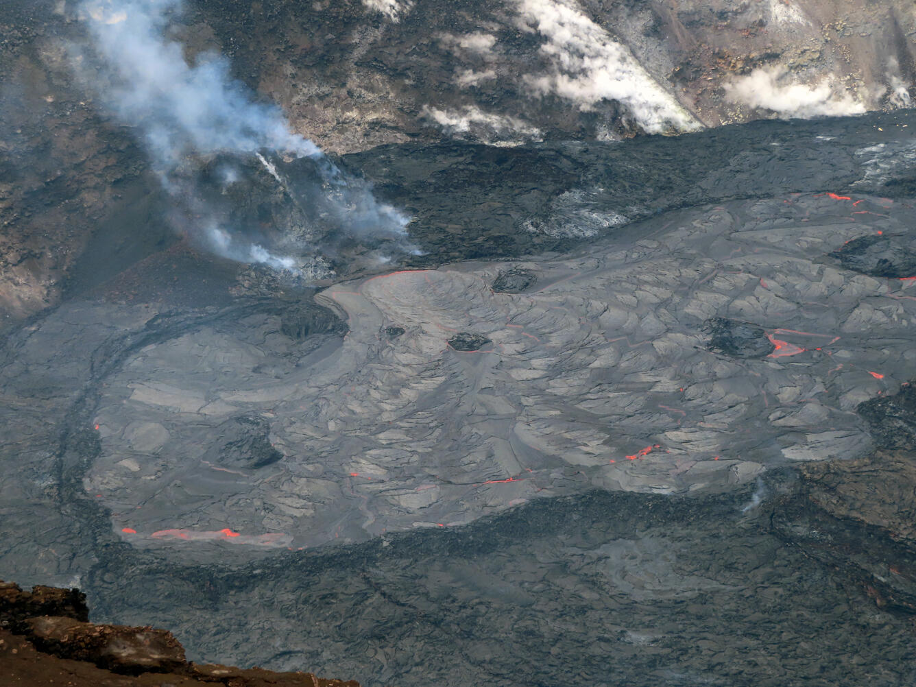
The lava lake in Halema‘uma‘u crater, at the summit of Kīlauea, remains active. Active surface lava is limited to the western portion of the lake, and is impounded by steep, well-defined levees. USGS photo by M. Patrick on March 22, 2021.
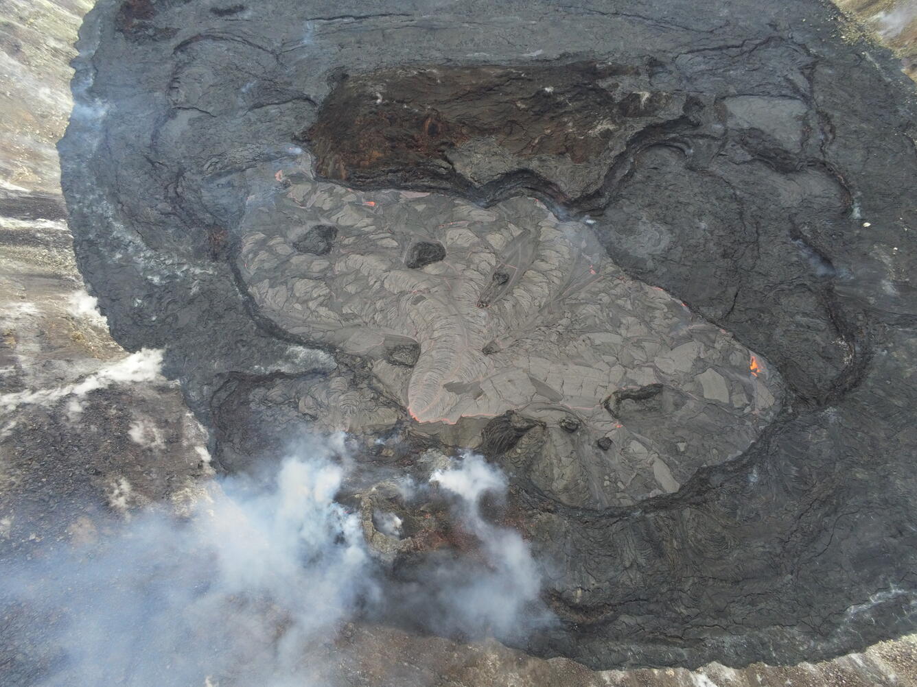
A close up of the inlet where lava from the western fissure feeds into the lake in Halema‘uma‘u, at the summit of Kīlauea. The inlet is formed from two adjacent lava streams. USGS photo by M. Patrick.
Crustal foundering—less-dense liquid lava overriding and sinking thin surface crust—is common in the lava lake within Halema‘uma‘u, at the summit of Kīlauea. Here, large sections of the crust are foundering, resurfacing the lake. USGS photo by M. Patrick on March 22, 2021.
This photo shows the levee that bounds the southern margin of the active lake in Halema‘uma‘u. The levee is formed, in part, by numerous small crustal plates pushed over the rim. USGS photo by M. Patrick on March 22, 2021.
This photo shows the northern portion of the active lava lake in Halema‘uma‘u, at the summit of Kīlauea. Like the southern portion of the lake, this northern zone is also contained by steep, well-defined levees. USGS photo by M. Patrick on March 22, 2021.
This photo shows one of the islands near the inlet in the lava lake in Halema‘uma‘u, at the summit of Kīlauea. Over the past two weeks, the island has tilted 90 degrees, producing the vertical layering visible here. USGS photo by M. Patrick on March 22, 2021.
This Unoccupied Aircraft Systems (UAS) photo provides an overview of the active western portion of the Halema‘uma‘u lava lake within Kīlauea caldera from Tuesday, March 16, 2021. The western fissure (lower-center) on the northwest side of Halema‘uma‘u was feeding lava through two submerged inlets to the active lake, which measured approximately 340 m (1115 ft) long from northeast (upper-left) to southwest (lower-right) at the time.UAS photos like this help scientists to understand ongoing lava lake processes with their associated hazards, and to detect changes that might indicate shifts in the character of eruptive activity. USGS has special use permits from the National Park Service to conduct official UAS missions as part of HVO's mission to monitor active volcanoes in Hawaii, assess their hazards, issue warnings, and advance scientific understanding to reduce impacts of volcanic eruptions. Launching, landing, or operating an unmanned aircraft from or on lands and waters administered by the National Park Service within the boundaries of Hawai‘i Volcanoes National Park is prohibited under 36 CFR Closures & Public Use.
This panorama of the western end of the Halema‘uma‘u lava lake within Kīlauea caldera was stitched together from four Unoccupied Aircraft Systems (UAS) photographs captured on Tuesday, March 16, 2021. The UAS was hovering just above the main island in the lava lake, approximately 270 m (886 ft) away from the western fissure, visible in the background. The fissure was feeding a new lava flow into the lake at the time, indicated by brighter incandescent spots along the far lake margin.UAS photos like this help scientists to understand ongoing lava lake processes with their associated hazards, and to detect changes that might indicate shifts in the character of eruptive activity. USGS has special use permits from the National Park Service to conduct official UAS missions as part of HVO's mission to monitor active volcanoes in Hawaii, assess their hazards, issue warnings, and advance scientific understanding to reduce impacts of volcanic eruptions. Launching, landing, or operating an unmanned aircraft from or on lands and waters administered by the National Park Service within the boundaries of Hawai‘i Volcanoes National Park is prohibited under 36 CFR Closures & Public Use.
This close-up Unoccupied Aircraft System (UAS) photo of the main island within the Halema‘uma‘u lava lake was captured on Tuesday, March 16, 2021. The surface of the island is dotted with angular lava fragments, estimated to measure less than 0.3 m (1 ft) in diameter. These are believed to have been ejected by small explosions from the lake surface in the early hours of the eruption on December 20–21, 2020. In the background to the right, the top of the northern fissure spatter cone is visible. This was the primary eruptive vent for the first week of the eruption.UAS photos like this help scientists to understand ongoing lava lake processes with their associated hazards, and to detect changes that might indicate shifts in the character of eruptive activity. USGS has special use permits from the National Park Service to conduct official UAS missions as part of HVO's mission to monitor active volcanoes in Hawaii, assess their hazards, issue warnings, and advance scientific understanding to reduce impacts of volcanic eruptions. Launching, landing, or operating an unmanned aircraft from or on lands and waters administered by the National Park Service within the boundaries of Hawai‘i Volcanoes National Park is prohibited under 36 CFR Closures & Public Use.
This close-up Unoccupied Aircraft Systems (UAS) photo of an island in the crusted-over eastern portion of the Halema‘uma‘u lava lake was captured on Tuesday, March 16, 2021. Cooling and thermal contraction have caused some of these islands to break apart, as seen in the lower-right of this photo, where some of the island's red, oxidized interior is exposed. Though considerably smaller than the main island in the lava lake, this island still measures approximately 80 m (262 ft) from end-to-end.UAS photos like this help scientists to understand ongoing lava lake processes with their associated hazards, and to detect changes that might indicate shifts in the character of eruptive activity. USGS has special use permits from the National Park Service to conduct official UAS missions as part of HVO's mission to monitor active volcanoes in Hawaii, assess their hazards, issue warnings, and advance scientific understanding to reduce impacts of volcanic eruptions. Launching, landing, or operating an unmanned aircraft from or on lands and waters administered by the National Park Service within the boundaries of Hawai‘i Volcanoes National Park is prohibited under 36 CFR Closures & Public Use.
This Unoccupied Aircraft Systems (UAS) photo from Tuesday, March 16, 2021 provides a profile view of the northeast side of the main island within the Halema‘uma‘u lava lake. The upper surface of the island is blanketed with tephra (brown) from the early days of the eruption, while layers of thin lava flows (black) are visible on the side of the island; the layered side of the island in the foreground is estimated to stand approximately 11 m (36 ft) tall.UAS photos like this help scientists to understand ongoing lava lake processes with their associated hazards, and to detect changes that might indicate shifts in the character of eruptive activity. USGS has special use permits from the National Park Service to conduct official UAS missions as part of HVO's mission to monitor active volcanoes in Hawaii, assess their hazards, issue warnings, and advance scientific understanding to reduce impacts of volcanic eruptions. Launching, landing, or operating an unmanned aircraft from or on lands and waters administered by the National Park Service within the boundaries of Hawai‘i Volcanoes National Park is prohibited under 36 CFR Closures & Public Use.