
Science in Support of Aquatic-Ecosystem Conservation and Restoration
Human land- and water-management practices have resulted in modifications to natural streamflow conditions and reduced the ecological health of aquatic communities. Working in collaboration with our many partners, the New England Water Science Center provides data and scientific analyses to inform and support aquatic-ecosystem conservation and restoration.
Identifying Stream Reaches with High Rates of Baseflow for Habitat Conservation and Stream Restoration to Support Endangered Atlantic Salmon in Maine
Maine is home to the Gulf of Maine Distinct Population Segment of Atlantic Salmon, the last remnant population of Atlantic Salmon in the United States. The identification and conservation of high-quality habitat, including stream reaches with high rates of groundwater discharge (baseflow) that provide cold water during the summer, is critical to their survival as a species. New England Water Science Center staff working in collaboration with colleagues at NOAA’s National Marine Services and the Maine Department of Marine Resources recently developed a statistical regression model to help resource managers assess relative amounts of baseflow in Maine streams with Atlantic Salmon habitat (Lombard and others, 2021; Lombard and Sturtevant, 2021).

The map below of the Narraguagus watershed in eastern coastal Maine shows stream reaches color-coded by relative amounts of baseflow predicted by the model, as an example of how results of the model can be applied throughout Maine. The map can be used to identify reaches with relatively higher amounts of baseflow during periods of low summer streamflow for habitat conservation and stream restoration.

Improved Fish Passage and Decreased Flood Inundation in Response to Dam Removals and Culvert Retrofits
A recently completed study by the New England Water Science Center was done to demonstrate the benefits of dam removal and culvert retrofits to restore aquatic connectivity for fish passage (Olson and Simeone, 2021; Simeone and others, 2021). Restoration of natural streamflow conditions also can improve water quality, sediment transport, and aquatic and riparian habitat, and decrease risks to surrounding communities from flood events and aging and inadequate infrastructure. The project was a collaborative effort between the Water Science Center and U.S. Fish and Wildlife Service.
River-hydraulic models were developed to evaluate velocity and depth suitability for fish passage and flood inundation at eight dam-removal sites in Massachusetts, Rhode Island, Connecticut, and New Jersey, and a single culvert-retrofit site in New Jersey. Model scenarios were done at each site for conditions prior to and after dam removal or culvert retrofit. The scenarios showed that fish passage was improved at all sites by removing the dams and retrofitting the undersized culvert.

Decreases in water-surface elevations and associated flood-inundation areas also resulted from the dam removals and culvert retrofit. The figure below illustrates inundation areas simulated for pre- and post-dam removal at the Hopewell Mills Dam site on the Mill River in Taunton, Massachusetts. The dam was one of three along the river that were removed between 2012 and 2018. Removal of the dams opened miles of aquatic habitat to migratory fish species and improved flood resiliency and safety in Taunton.
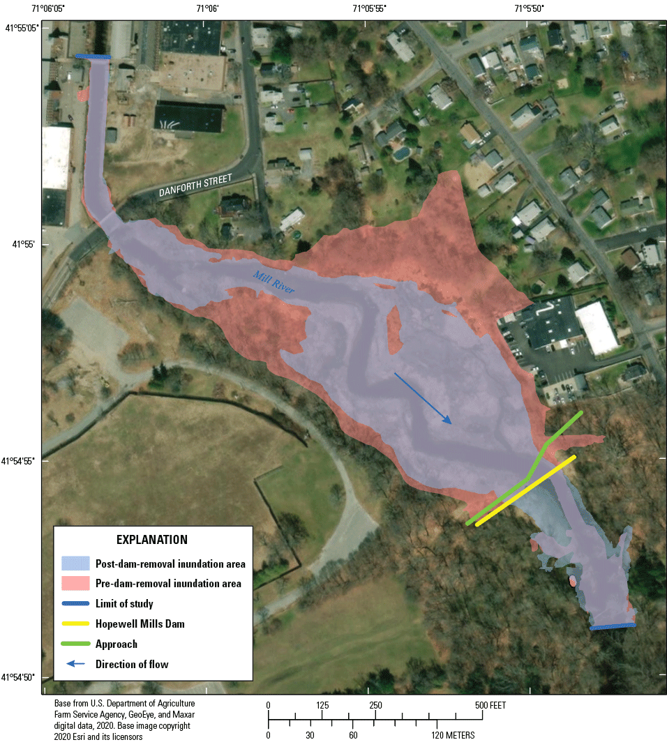
Inundation areas at the Hopewell Mills Dam study site, Taunton, Massachusetts, for model simulations at the 1-percent annual exceedance probability discharge (Olson and Simeone, 2021). Removal of the dam decreased the water-surface elevation by 10.4 feet immediately upstream from the dam location at this simulated rate of discharge.
Get Our News
These items are in the RSS feed format (Really Simple Syndication) based on categories such as topics, locations, and more. You can install and RSS reader browser extension, software, or use a third-party service to receive immediate news updates depending on the feed that you have added. If you click the feed links below, they may look strange because they are simply XML code. An RSS reader can easily read this code and push out a notification to you when something new is posted to our site.