
Volcano Watch — On the surface of Kīlauea's new landscape, a story is told
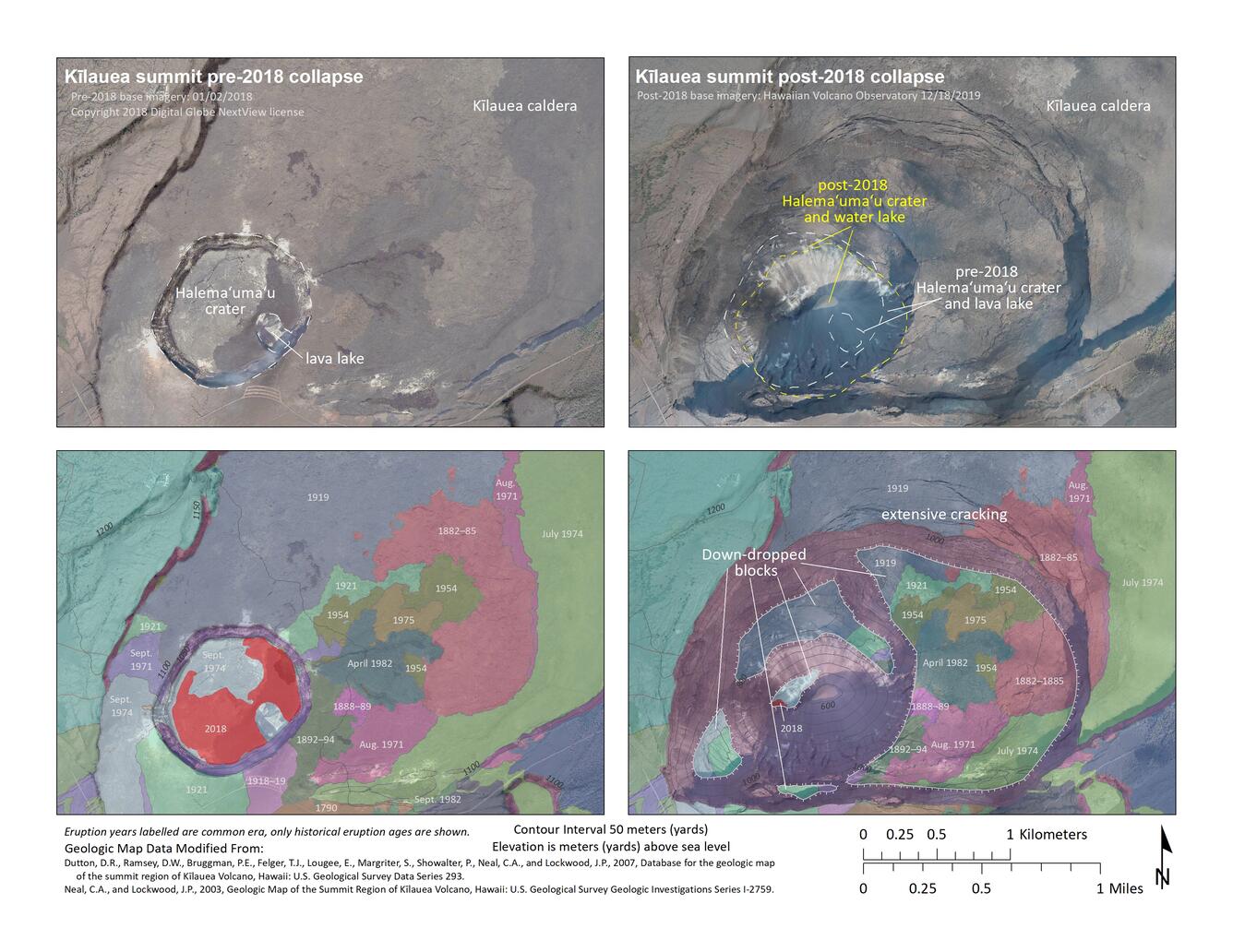
Kīlauea's 2018 summit collapse dramatically transformed the geometry and appearance of Halema‘uma‘u crater and Kīlauea caldera. Last week's "Volcano Watch" article described how the 2018 events impacted the magma plumbing system beneath the surface of Kīlauea's summit. This week, we'll explore how the 2018 events impacted the geologic deposits on the surface.
Volcano Watch is a weekly article and activity update written by U.S. Geological Survey Hawaiian Volcano Observatory scientists and colleagues.
Kīlauea's summit is no stranger to change. Several summit drainages or collapses in the nineteenth and early twentieth centuries are documented in early western accounts. Reverend William Ellis, author of the first written description of Kīlauea, observed of the summit in 1823, "...that the crater had been recently filled with liquid lava...and had, by some subterranean canal, emptied itself into the sea, or inundated the low land on the shore."
Ellis' description hypothesizes that Kīlauea's summit had been erupting before a flank eruption drained the summit. Indeed, an eruption of Kīlauea's Southwest Rift Zone in 1823 may have contributed to the summit collapse that Ellis described, much like Kīlauea's summit collapse in 2018 was accompanied by the lower East Rift Zone eruption.
Kīlauea's summit was partially drained, sometimes leading to enlargement of Halema‘uma‘u or collapse of portions of the caldera floor, in 1823, 1832, 1840, 1868, 1886, 1891, 1894, 1916, 1919, 1922, 1924, and 2018. It's unclear why Kīlauea summit collapses were less frequent in the past century, but perhaps prolonged flank eruptions on Kīlauea's middle East Rift Zone (Mauna Ulu 1969–1974 and Pu‘u ‘Ō‘ō 1983–2018) played a part.
Some Kīlauea summit drainages or collapses were accompanied by lower-elevation flank eruptions; others, by likely "failed" eruptions, wherein magma intruded into the flank of the volcano but wasn't erupted onto the surface.
In the past, Halema‘uma‘u crater was described as being transformed into a pit of "tumbled masses of rock blocks" after a drainage or collapse of Kīlauea summit. This description is certainly applicable to the current appearance of Halema‘uma‘u, with its steep crater walls and rubble base.
Nineteenth-century descriptions of Kīlauea summit after a collapse sometimes describe a "black ledge"—evidence of summit lava-lake activity—bordering collapsed areas. Though there was a summit lava lake before the 2018 collapse, it left no such "black ledge;" those deposits are now part of the rubble at the base of Halema‘uma‘u. The 2018 collapse almost completely erased the geologic evidence of Kīlauea's 2008–2018 summit lava lake! How did the 2018 summit collapse impact other geologic deposits within Kīlauea caldera?
A comparison of pre- and post-2018 geologic maps shows that before 2018, the floor of Halema‘uma‘u crater consisted of lava flows erupted in 1974 and 1982 and overflows from the 2008–2018 summit lava lake. All of these deposits are now part of the rubble at the base of the current (post-2018) Halema‘uma‘u. Now, another type of lake (water) occupies the bottom of Halema‘uma‘u, although not in the same location as the 2008–2018 lava lake.
The 2018 Kīlauea summit collapse also impacted a broader area of Kīlauea caldera. Before 2018, Kīlauea caldera floor was a mosaic of different-aged lava flows—nineteenth century flows that inundated much of the caldera floor mostly overlain by more recent flows from summit eruptions in 1918–1919, 1919, 1921, 1954, 1971, 1974, 1975, and 1982.
During the many earthquakes that accompanied the collapse events of 2018, these deposits on the floor of Kīlauea caldera were jostled, cracked, and shifted. Portions of them were lowered over one hundred meters (yards) and likely shifted laterally several tens of meters (yards).
Fragments of these older lava flow deposits remain intact on the "down-dropped blocks" that formed within Kīlauea caldera during 2018. Lava flows from 1919 and 1974 are on the surface of the smaller down-dropped blocks, and numerous lava flows erupted over the past 150 years remain on the largest of the down-dropped blocks.
More detailed future geologic mapping will reveal how much these deposits were impacted by Kīlauea's 2018 collapse. A previous "Volcano Watch" article describes the new outcrops exposed in the fault scarps formed during 2018 and their importance to better understanding Kīlauea's eruptive history.
Changes to Kīlauea's summit as a result of the 2018 collapse are profound, but not permanent. As the record over the past two centuries demonstrates, Kīlauea's summit will erupt and collapse again (and again), repeatedly transforming the summit geometry and appearance in the process.
Volcano Activity Update
Kīlauea Volcano is not erupting. Its USGS Volcano Alert level remains at NORMAL. Kīlauea updates are issued monthly.
Kīlauea monitoring data for the past month show variable but typical rates of seismicity and ground deformation, low rates of sulfur dioxide emissions, and only minor geologic changes since the end of eruptive activity in September 2018. The water lake at the bottom of Halema‘uma‘u continues to slowly expand and deepen. For the most current information on the lake, see https://volcanoes.usgs.gov/volcanoes/kilauea/summit_water_resources.html
Mauna Loa is not erupting and remains at Volcano Alert Level ADVISORY. This alert level does not mean that an eruption is imminent or that progression to an eruption from current level of unrest is certain. Mauna Loa updates are issued weekly.
This past week, about 70 small-magnitude earthquakes were recorded beneath the upper-elevations of Mauna Loa; most of these occurred at shallow depths of less than 8 kilometers (about 5 miles). Global Positioning System (GPS) measurements show long-term slowly increasing summit inflation, consistent with magma supply to the volcano's shallow storage system. Gas concentrations and fumarole temperatures as measured at both Sulphur Cone and the summit remain stable. Webcams show no changes to the landscape. For more information on current monitoring of Mauna Loa Volcano, see: https://volcanoes.usgs.gov/volcanoes/mauna_loa/monitoring_summary.html.
There were 5 events with 3 or more felt reports in the Hawaiian Islands during the past week: a M2.9 earthquake 14 km (8 mi) N of Kukuihaele at 23 km (14 mi) depth on Sept. 9 at 5:47 p.m. HST, a M3.0 earthquake 8 km (4 mi) E of Pāhala at 32 km (20 mi) depth on Sept. 9 at 12:18 a.m. HST, a M3.4 earthquake 1 km (0 mi) SE of Pāhala at 31 km (19 mi) depth on Sept. 6 at 2:19 a.m. HST, a M2.6 earthquake 15 km (9 mi) N of Pāhala at 9 km (6 mi) depth on Sept. 5 at 5:04 p.m. HST, and a M3.7 earthquake 2 km (1 mi) N of Hāli‘imaile at 31 km (19 mi) depth on Sept. 4 at 9:43 p.m. HST.
HVO continues to closely monitor both Kīlauea and Mauna Loa for any signs of increased activity.
Get Our News
These items are in the RSS feed format (Really Simple Syndication) based on categories such as topics, locations, and more. You can install and RSS reader browser extension, software, or use a third-party service to receive immediate news updates depending on the feed that you have added. If you click the feed links below, they may look strange because they are simply XML code. An RSS reader can easily read this code and push out a notification to you when something new is posted to our site.