
Water Science in the Lake Tahoe Basin
Lake Tahoe currently attracts almost 3 million visitors a year. After the 1960 Winter Olympics at Squaw Valley, it became a major tourist attraction, which resulted in increased development and an influx of motorized watercraft to the lake. Damage to the lake became noticeable with a reduction in lake clarity. This catalyzed a movement to use science and regional planning to reduce human impacts.
To help with the science and regional planning for Lake Tahoe, the U.S. Geological Survey is delivering a range of science through its hydrologists, geologists, geographers, biologists, computer modeling experts and others. The USGS provides a wide range of consistent, reliable, long-term data and maps that are crucial for evaluating and managing the lake and basin.
Decision-making, informed and driven by science, has had and will have a major impact on protecting, preserving, and restoring the quality of the environment. It remains an essential part of policy development in the Tahoe Basin.
Lake Elevation
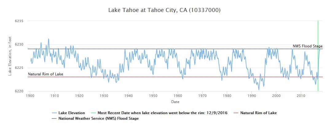
The USGS has been measuring surface-water levels at Lake Tahoe since April 30, 1900. The lake's surface level varies from year-to-year. It can reach flood stage (6,229.1 ft elevation) during wet years, and fall below the natural rim (6,223 ft elevation) during times of drought.
Streamflow

Streamgages on several streams entering the lake, one on the Truckee River leaving the lake, and at other locations on the Truckee River and its tributaries deliver round-the-clock data to the USGS National Water Information System (NWIS). These are essential to water management and deliveries in the Tahoe Basin and downstream. Streamgages record the vertical rise or drop in water levels and deliver their data via satellite every 15 minutes. This data helps in flood risk management, and is essential to the Federal Water Master, who is responsible for allocating water deliveries from the Truckee River in accordance with the Truckee River Operating Agreement. This data also allows the monitoring of Lake Tahoe's elevation. After a number of years when the lake elevation dipped below its natural rim, Lake Tahoe came within an inch of its maximum elevation of 6,229.1' in the summer of 2017.
Water Quality
One of the major concerns at Lake Tahoe is the amount of nutrients and suspended sediment entering the lake from the streams, which impact water quality and clarity. In a long-term effort since the 1980's, the USGS, in cooperation with its partners
has been sampling 10 of the 63 streams that enter the lake. This data collection enables scientist to estimate what is entering the lake from all the streams.
USGS sampling from the lake itself, in cooperation with the Lake Tahoe Regional Planning Agency, revealed that 2-stroke jet skis were polluting the lake with organic compounds. The jet skis were banned in 1999. Water quality monitoring continues before and during boating season to ensure that water quality is maintained throughout the year. Samples are sent to the USGS water analysis lab in Denver where they are analyzed for extremely low levels of boat-fuel components.
Lake Floor and Tahoe Basin Mapping

Twenty years ago, the USGS developed a 3-D map of the lake floor. Until the advent of this map, no one knew what the lake bottom looked like. The USGS made 15 million individual depth measurements to create the bathymetry. This allows scientists and managers the ability to analyze and understand the processes, such as landslides, that are happening on the lake floor.


Now, the USGS is using LiDAR (Light Detection and Ranging) technology to map the entire Tahoe basin. Collecting, analyzing, and disseminating high resolution LiDAR and multispectral imagery for the Lake Tahoe Basin provides the level of spatial and temporal refinement necessary to make decisions about current conditions in the basin. LiDAR technology allows a view under the vegetation and reveals features never-before known such as faults.
Using areal photography scientists can look at changes in the basin that took place in the past. This is instructive for USGS geographers developing land-use simulations for future land-use planning. This "decision support tool" can be used to model potential fire effects, or water quality impacts 20 years into the future given land-use choices and development, that could be implemented today. This allows for informed choices for Tahoe's future.

Lake of the Sky: USGS Tahoe Basin Science