



Evaluating the Effects of Stream-Restoration Practices in an Impaired Agricultural System
Stream-restoration practices are widely used throughout the Chesapeake Bay watershed to improve stream health and function, but research into their effectiveness is limited in agricultural settings. A study in Turtle Creek, Pennsylvania, suggests that stream-restoration practices can significantly reduce streambank erosion and enhance floodplain deposition, changes that can reduce in-stream sediment loads and improve habitat for fish and other stream biota.
Issue
Stream-restoration practices are a common management approach that are often designed to reduce the amount of nitrogen, phosphorus, and sediment in streams. By doing so, these practices can improve local river conditions and help meet Chesapeake Bay water-quality goals. To maximize these benefits, local practitioners need insights from monitoring studies to guide the design of stream-restoration practices and to evaluate their performance. These studies are greatly needed in agricultural settings, where stream restorations have been monitored far less frequently than in urban and suburban areas. Expanded monitoring in agricultural settings can provide key insights about how to best design and implement cost-effective practices- information that can guide the development of programs used to credit the performance of stream restoration practices.
USGS Study
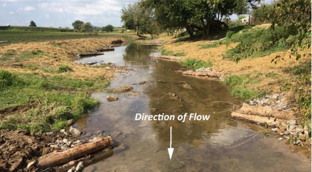
Over a 3-year period, the USGS conducted field cross-sectional geomorphic change measurements and collected aerial imagery from uncrewed drones in multiple restored and unrestored stream reaches in the watershed of Turtle Creek, Pennsylvania. All restoration projects were completed by state and local partners within the previous one to six years of the initiation of this study, by implementing a cost-efficient approach that used soft engineering practices. These practices focused on using materials such as logs and natural backfill to stabilize regraded streambanks and reconnect the stream channel and floodplain (Figure 1). The USGS measured sediment erosion from streambanks, deposition on floodplains, and fine sediment trapped in the streambed. Results of these field-based methods were compared to aerial imagery to evaluate how accurately data from uncrewed drones can be used to characterize stream-restoration practices.
Major Findings
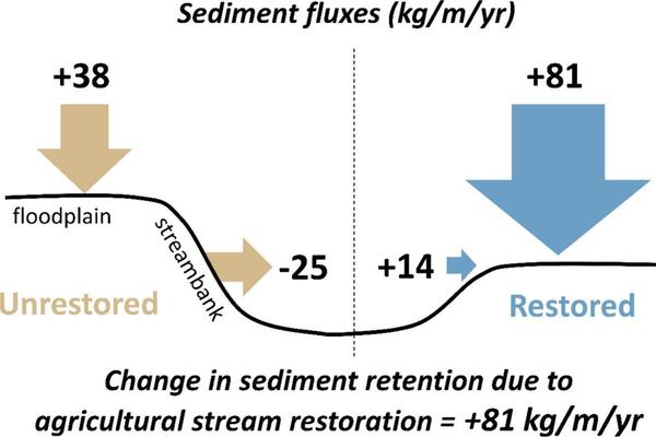
- Restored reaches showed a 7-fold increase in net sediment retention (Figure 2).
- Stream restoration changed streambank sediment flux from erosional to depositional.
- Stream restoration increased floodplain deposition the most in smaller headwaters.
- Restored reaches had coarser streambed sediments than unrestored reaches, which may provide improved habitat quality for stream biota.
- Digital elevation models produced from drone-acquired data improved assessments.
Management Implications
Stream restoration improved the water quality and stream habitat of Turtle Creek, demonstrating that less-engineered approaches to restoring stream valleys can be effective in agricultural settings. These results provide data to support accurate crediting of stream restorations in agricultural settings. Separately from this study, segments of Turtle Creek were delisted from the Clean Water Act 303d list of impaired waters following stream restorations that improved stream biota.
The addition of aerial imagery from uncrewed drones complemented standard field-based assessments of stream condition and change. Costs associated with field-based monitoring are often a concern, and repeated ground-based surveys can be expensive to conduct at the scale and resolution that processed drone imagery can provide.
For More Information
The full study is published online with open access: https://doi.org/10.1016/j.ecoleng.2026.108082.
Stream-restoration practices are widely used throughout the Chesapeake Bay watershed to improve stream health and function, but research into their effectiveness is limited in agricultural settings. A study in Turtle Creek, Pennsylvania, suggests that stream-restoration practices can significantly reduce streambank erosion and enhance floodplain deposition, changes that can reduce in-stream sediment loads and improve habitat for fish and other stream biota.
Issue
Stream-restoration practices are a common management approach that are often designed to reduce the amount of nitrogen, phosphorus, and sediment in streams. By doing so, these practices can improve local river conditions and help meet Chesapeake Bay water-quality goals. To maximize these benefits, local practitioners need insights from monitoring studies to guide the design of stream-restoration practices and to evaluate their performance. These studies are greatly needed in agricultural settings, where stream restorations have been monitored far less frequently than in urban and suburban areas. Expanded monitoring in agricultural settings can provide key insights about how to best design and implement cost-effective practices- information that can guide the development of programs used to credit the performance of stream restoration practices.
USGS Study
Over a 3-year period, the USGS conducted field cross-sectional geomorphic change measurements and collected aerial imagery from uncrewed drones in multiple restored and unrestored stream reaches in the watershed of Turtle Creek, Pennsylvania. All restoration projects were completed by state and local partners within the previous one to six years of the initiation of this study, by implementing a cost-efficient approach that used soft engineering practices. These practices focused on using materials such as logs and natural backfill to stabilize regraded streambanks and reconnect the stream channel and floodplain (Figure 1). The USGS measured sediment erosion from streambanks, deposition on floodplains, and fine sediment trapped in the streambed. Results of these field-based methods were compared to aerial imagery to evaluate how accurately data from uncrewed drones can be used to characterize stream-restoration practices.
Major Findings
- Restored reaches showed a 7-fold increase in net sediment retention (Figure 2).
- Stream restoration changed streambank sediment flux from erosional to depositional.
- Stream restoration increased floodplain deposition the most in smaller headwaters.
- Restored reaches had coarser streambed sediments than unrestored reaches, which may provide improved habitat quality for stream biota.
- Digital elevation models produced from drone-acquired data improved assessments.
Management Implications
Stream restoration improved the water quality and stream habitat of Turtle Creek, demonstrating that less-engineered approaches to restoring stream valleys can be effective in agricultural settings. These results provide data to support accurate crediting of stream restorations in agricultural settings. Separately from this study, segments of Turtle Creek were delisted from the Clean Water Act 303d list of impaired waters following stream restorations that improved stream biota.
The addition of aerial imagery from uncrewed drones complemented standard field-based assessments of stream condition and change. Costs associated with field-based monitoring are often a concern, and repeated ground-based surveys can be expensive to conduct at the scale and resolution that processed drone imagery can provide.
For More Information
The full study is published online with open access: https://doi.org/10.1016/j.ecoleng.2026.108082.