



Exploring Wild Bird Movements to Understand Avian Influenza Risk for Poultry Farms on the Delmarva Peninsula
A recent collaborative study involving USGS, University of Delaware, University of California Davis, and Canadian colleagues used GPS tracking to learn how Canada Geese and Snow Geese use the landscape when wintering on the Delmarva Peninsula. These data were then used to understand location-based risk factors for the spread of Highly Pathogenic Avian Influenza Virus (HPAIV) to commercial poultry farms.
Issue
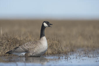
HPAIV has caused extensive mortality in wild birds and domestic poultry since the incursion of Clade 2.3.4.4b H5N1 into North America in the winter of 2021-2022. These impacts have been felt across the country, with several outbreaks detected on commercial poultry farms on the Delmarva Peninsula. Wild birds, such as Canada Geese (Figure 1) and Greater Snow Geese, are believed to shed the virus into the environment, where it can be carried into poultry houses by people, equipment, wind, water, or wild bridge species.
USGS Study
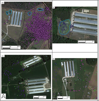
59 Snow Geese and 9 Canada Geese were tagged with GPS trackers that recorded the birds’ locations every 5 minutes (Figure 2). Using information from over 6,000 poultry farms across Delmarva, a risk ranking system was established for each farm. In addition to goose activity, the study investigated how temperature, time of winter, land types, and distance to features such as waterbodies or the coast, affected the birds’ behavior.
Major Findings
This study found that the risk ranking system effectively predicted outbreak risks; farms that later contracted HPAI were almost all in the top 25% of goose exposure.
What did the Geese tracking show us?
- Snow Geese visited farms mostly during the middle and end of winter, especially when temperatures were below freezing, while Canada Geese visited in early winter and again at the end of winter.
- Both species came close to farms during the day and at night.
- Geese frequented farms that were close to sewage treatment plants, wildlife refuges, waterbodies, and crop fields.
- Snow Geese were especially attracted to large farm areas with lots of crops and little forest, while Canada Geese were more drawn to wetlands, streams, and pastures.
- Farms that were in clusters or groups also saw more Snow Goose activity.
GPS tracking shows that wintering geese are frequently near poultry farms on the Delmarva Peninsula. Their presence strongly matches where avian influenza outbreaks later occurred. By using goose activity data, farms and response teams can better prepare, especially in high‑risk areas or during colder periods. This helps protect both poultry and the people who depend on the poultry industry. Overall, the patterns showed that certain locations, seasons, and weather conditions increase the chances that geese will come near poultry farms, raising the risk of avian influenza.
Management Implications
Knowing where and when geese visit farms helps agencies plan better disease prevention, protect farmers, and avoid large outbreaks. HPAI can spread quickly and cause huge losses in poultry, which is an important part of the food supply. These outbreaks can cost millions of dollars by forcing farms to destroy sick birds, shut down production, and slow the sale of chicken, eggs, and turkey. These impacts can affect workers, businesses, and grocery store prices. Understanding the risk factors associated with waterfowl overlap allows managers to plan and protect their farms. By using GPS data to find high‑risk areas, government partners can make more informed decisions, support farmers, and help protect regional and national economic stability.
For More Information
The full study is published online with open access: https://doi.org/10.1371/journal.pone.0355415.
A recent collaborative study involving USGS, University of Delaware, University of California Davis, and Canadian colleagues used GPS tracking to learn how Canada Geese and Snow Geese use the landscape when wintering on the Delmarva Peninsula. These data were then used to understand location-based risk factors for the spread of Highly Pathogenic Avian Influenza Virus (HPAIV) to commercial poultry farms.
Issue
HPAIV has caused extensive mortality in wild birds and domestic poultry since the incursion of Clade 2.3.4.4b H5N1 into North America in the winter of 2021-2022. These impacts have been felt across the country, with several outbreaks detected on commercial poultry farms on the Delmarva Peninsula. Wild birds, such as Canada Geese (Figure 1) and Greater Snow Geese, are believed to shed the virus into the environment, where it can be carried into poultry houses by people, equipment, wind, water, or wild bridge species.
USGS Study
59 Snow Geese and 9 Canada Geese were tagged with GPS trackers that recorded the birds’ locations every 5 minutes (Figure 2). Using information from over 6,000 poultry farms across Delmarva, a risk ranking system was established for each farm. In addition to goose activity, the study investigated how temperature, time of winter, land types, and distance to features such as waterbodies or the coast, affected the birds’ behavior.
Major Findings
This study found that the risk ranking system effectively predicted outbreak risks; farms that later contracted HPAI were almost all in the top 25% of goose exposure.
What did the Geese tracking show us?
- Snow Geese visited farms mostly during the middle and end of winter, especially when temperatures were below freezing, while Canada Geese visited in early winter and again at the end of winter.
- Both species came close to farms during the day and at night.
- Geese frequented farms that were close to sewage treatment plants, wildlife refuges, waterbodies, and crop fields.
- Snow Geese were especially attracted to large farm areas with lots of crops and little forest, while Canada Geese were more drawn to wetlands, streams, and pastures.
- Farms that were in clusters or groups also saw more Snow Goose activity.
GPS tracking shows that wintering geese are frequently near poultry farms on the Delmarva Peninsula. Their presence strongly matches where avian influenza outbreaks later occurred. By using goose activity data, farms and response teams can better prepare, especially in high‑risk areas or during colder periods. This helps protect both poultry and the people who depend on the poultry industry. Overall, the patterns showed that certain locations, seasons, and weather conditions increase the chances that geese will come near poultry farms, raising the risk of avian influenza.
Management Implications
Knowing where and when geese visit farms helps agencies plan better disease prevention, protect farmers, and avoid large outbreaks. HPAI can spread quickly and cause huge losses in poultry, which is an important part of the food supply. These outbreaks can cost millions of dollars by forcing farms to destroy sick birds, shut down production, and slow the sale of chicken, eggs, and turkey. These impacts can affect workers, businesses, and grocery store prices. Understanding the risk factors associated with waterfowl overlap allows managers to plan and protect their farms. By using GPS data to find high‑risk areas, government partners can make more informed decisions, support farmers, and help protect regional and national economic stability.
For More Information
The full study is published online with open access: https://doi.org/10.1371/journal.pone.0355415.