
Smart Phone Application for DOI Oil Spill Responders
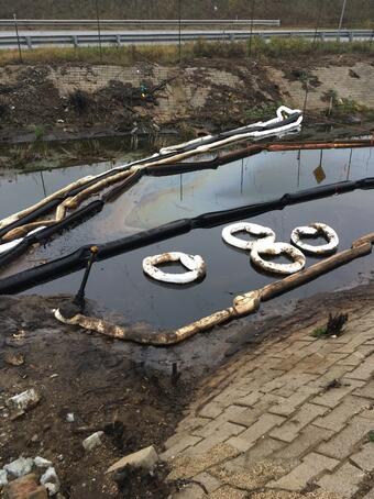
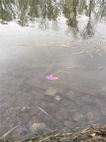
Semiquantitative analysis of hydrocarbons in the field is a major challenge for oil spill responders. This data imperative for sample collection and rapid decision making.
The Issue: Standard analytical methods require samples to be collected and shipped to the laboratory. Although these laboratory‐based methods provide data with a high degree of confidence, they often take weeks to months to get results. This approach can be costly, require time delays for results, and result in many non‐detects.
Our Approach: The overall goal of this project was to develop new techniques or capabilities that will enhance spill response efforts. We are developing a cell phone application for use by DOI personnel for semi‐quantitative analysis of oil spills in the field.
The team started the project by developing their first prototype which relied on a 3D printer cell phone camera adapter for collecting images.
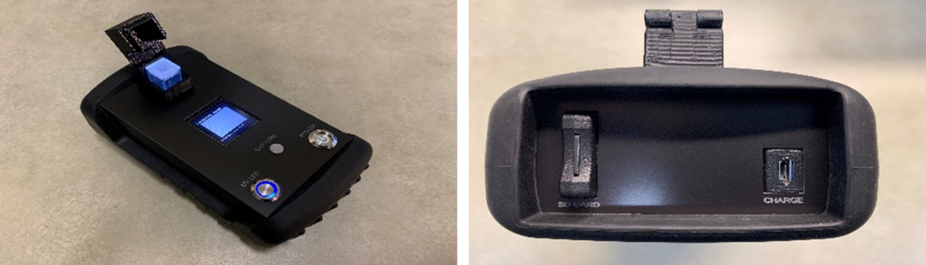
After reviewing suggestions from the intended user group, the team developed a stand‐alone device that is handheld, low power, Wi-Fi enabled and can collect high resolution fluorescent images (Figure 1). This device is currently being optimized for connectivity to the smart phone, illuminating light intensity, optimal wavelength for fluorescence, and incorporating a screen interface.
A machine learning model has been developed and was demonstrated to accurately predict oil concentrations (2 to 500 mg/L) using the Macondo 252 oil as a calibration standard. The results of the model development have been accepted for publication in the Journal of Environmental Informatics and has a provisional patent (US No 63/307104) (Steevens J 2022; Liu et al., 2023).
Brief details of the machine learning model:
- The model was trained with 1500 images and a blind test of 500 images to test the model.
- The model is supported by a smart phone application that can run on Android or iPhone.
- The model is hosted on the smart phone and remotely through a secure server. The secure server also supports a database for curating site images and analysis results.
Next steps: The team is currently optimizing the model using various types of crude oil. Well characterized samples of degraded oils will also be tested to examine the ability of the tool to quantify total oil and indications of chemical transformation.
This information will be used to improve the accuracy of predictions and reduce the program's running time. Additionally, results of the smart phone analysis will be compared to conventional chemistry to evaluate response variability due to oil types and weathering. This will also determine the phone’s ability to accurately measure oil levels and minimize confounding factors/interferences.
The team is actively:
- Implementing a mobile application for Android and iOS where users can obtain pictures from the device to upload the pictures to the server to get prediction results.
- Integrating a local prediction model version to predict oil concentration without a network connection.
- Developing a database site to manage all user‐uploaded water images. Designated users can log into the database system to search and sort all the water images data. More complex search functions will be enabled and improved.
- Demonstrating smart phone oil detection capability in the field. The goal of the site demonstration is to provide an opportunity for oil spill responder users to have “hands‐on” use of the tool set in the field under conditions similar to an oil spill event.
Broader Implications of this Technology: Advanced technologies, such as this tool, can provide a low‐cost, easy-to-use method that can be rapidly deployed for use in the field by the oil spill responder community. This handheld tool with advanced machine learning capabilities will semi-quantify oil spills allowing oil spill responders to promptly address the situation and determine the appropriate site-specific response measures required.
Return to Columbia Environmental Research Center
Return to Mizzou Engineering
Return to Jordan Valley Innovation Center
Semiquantitative analysis of hydrocarbons in the field is a major challenge for oil spill responders. This data imperative for sample collection and rapid decision making.
The Issue: Standard analytical methods require samples to be collected and shipped to the laboratory. Although these laboratory‐based methods provide data with a high degree of confidence, they often take weeks to months to get results. This approach can be costly, require time delays for results, and result in many non‐detects.
Our Approach: The overall goal of this project was to develop new techniques or capabilities that will enhance spill response efforts. We are developing a cell phone application for use by DOI personnel for semi‐quantitative analysis of oil spills in the field.
The team started the project by developing their first prototype which relied on a 3D printer cell phone camera adapter for collecting images.
After reviewing suggestions from the intended user group, the team developed a stand‐alone device that is handheld, low power, Wi-Fi enabled and can collect high resolution fluorescent images (Figure 1). This device is currently being optimized for connectivity to the smart phone, illuminating light intensity, optimal wavelength for fluorescence, and incorporating a screen interface.
A machine learning model has been developed and was demonstrated to accurately predict oil concentrations (2 to 500 mg/L) using the Macondo 252 oil as a calibration standard. The results of the model development have been accepted for publication in the Journal of Environmental Informatics and has a provisional patent (US No 63/307104) (Steevens J 2022; Liu et al., 2023).
Brief details of the machine learning model:
- The model was trained with 1500 images and a blind test of 500 images to test the model.
- The model is supported by a smart phone application that can run on Android or iPhone.
- The model is hosted on the smart phone and remotely through a secure server. The secure server also supports a database for curating site images and analysis results.
Next steps: The team is currently optimizing the model using various types of crude oil. Well characterized samples of degraded oils will also be tested to examine the ability of the tool to quantify total oil and indications of chemical transformation.
This information will be used to improve the accuracy of predictions and reduce the program's running time. Additionally, results of the smart phone analysis will be compared to conventional chemistry to evaluate response variability due to oil types and weathering. This will also determine the phone’s ability to accurately measure oil levels and minimize confounding factors/interferences.
The team is actively:
- Implementing a mobile application for Android and iOS where users can obtain pictures from the device to upload the pictures to the server to get prediction results.
- Integrating a local prediction model version to predict oil concentration without a network connection.
- Developing a database site to manage all user‐uploaded water images. Designated users can log into the database system to search and sort all the water images data. More complex search functions will be enabled and improved.
- Demonstrating smart phone oil detection capability in the field. The goal of the site demonstration is to provide an opportunity for oil spill responder users to have “hands‐on” use of the tool set in the field under conditions similar to an oil spill event.
Broader Implications of this Technology: Advanced technologies, such as this tool, can provide a low‐cost, easy-to-use method that can be rapidly deployed for use in the field by the oil spill responder community. This handheld tool with advanced machine learning capabilities will semi-quantify oil spills allowing oil spill responders to promptly address the situation and determine the appropriate site-specific response measures required.
Return to Columbia Environmental Research Center
Return to Mizzou Engineering
Return to Jordan Valley Innovation Center