
Mongolia - Building Groundwater Modeling Capacity
Project Period: 2015-2016
Cooperator: U.S. Army Corps of Engineers
Project Chief: Joshua Valder
Executive Summary
The U.S. Geological Survey (USGS), in collaboration with the U.S. Army Corps of Engineers, is providing groundwater training and capacity building in groundwater modeling using MODFLOW for Mongolia. The goal of the training is to provide understanding of groundwater principles, aquifer characterization, and data acquisition needed to design, construct, calibrate, and use groundwater models. These goals will be met by:
- Establishing fundamentals of groundwater flow, hydrologic budgets, and aquifer properties
- Developing background to be able to assess groundwater availability and sustainability
- Developing familiarity and skills in the use of MODFLOW, with an emphasis on packages and methodologies that would be most useful for regional modeling of the Tuul River Basin in Mongolia
- Introducing concepts of model calibration and model uncertainty.
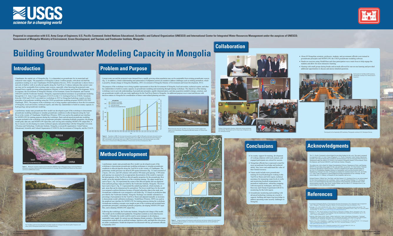
Scientists from the USGS and USACE provided two workshops (Phase I and Phase II training) in 2015 to Mongolian hydrology experts on basic principles of groundwater modeling using the USGS groundwater modeling program MODFLOW-2005 (Harbaugh, 2005). The purpose of the workshops was to bring together representatives from the Government of Mongolia, local universities, technical experts, and other key stakeholders to build in-country capacity in hydrogeology and groundwater modeling. Additional workshops and expansion of work to include the Gobi region are planned.
Problem
Ulaanbaatar, the capital city of Mongolia (fig. 1), is dependent on groundwater for its municipal and industrial water supply. The population of Mongolia is about 3 million people, with about one-half the population residing in or near Ulaanbaatar (World Population Review, 2016). Groundwater is drawn from a network of shallow wells in an alluvial aquifer along the Tuul River. Evidence indicates that current water use and especially the projected water demand from a rapidly growing urban population, may not be sustainable from existing water sources (Ministry of Environment and Green Development, 2013). In response, the Government of Mongolia (GoM) Ministry of Environment, Green Development, and Tourism (MEGDT) and the Mongolian Fresh Water Institute requested technical assistance on groundwater modeling through the U.S. Army Corps of Engineers to the U.S. Geological Survey (USGS).

Below are multimedia items associated with this project.

Project Period: 2015-2016
Cooperator: U.S. Army Corps of Engineers
Project Chief: Joshua Valder
Executive Summary
The U.S. Geological Survey (USGS), in collaboration with the U.S. Army Corps of Engineers, is providing groundwater training and capacity building in groundwater modeling using MODFLOW for Mongolia. The goal of the training is to provide understanding of groundwater principles, aquifer characterization, and data acquisition needed to design, construct, calibrate, and use groundwater models. These goals will be met by:
- Establishing fundamentals of groundwater flow, hydrologic budgets, and aquifer properties
- Developing background to be able to assess groundwater availability and sustainability
- Developing familiarity and skills in the use of MODFLOW, with an emphasis on packages and methodologies that would be most useful for regional modeling of the Tuul River Basin in Mongolia
- Introducing concepts of model calibration and model uncertainty.
Scientists from the USGS and USACE provided two workshops (Phase I and Phase II training) in 2015 to Mongolian hydrology experts on basic principles of groundwater modeling using the USGS groundwater modeling program MODFLOW-2005 (Harbaugh, 2005). The purpose of the workshops was to bring together representatives from the Government of Mongolia, local universities, technical experts, and other key stakeholders to build in-country capacity in hydrogeology and groundwater modeling. Additional workshops and expansion of work to include the Gobi region are planned.
Problem
Ulaanbaatar, the capital city of Mongolia (fig. 1), is dependent on groundwater for its municipal and industrial water supply. The population of Mongolia is about 3 million people, with about one-half the population residing in or near Ulaanbaatar (World Population Review, 2016). Groundwater is drawn from a network of shallow wells in an alluvial aquifer along the Tuul River. Evidence indicates that current water use and especially the projected water demand from a rapidly growing urban population, may not be sustainable from existing water sources (Ministry of Environment and Green Development, 2013). In response, the Government of Mongolia (GoM) Ministry of Environment, Green Development, and Tourism (MEGDT) and the Mongolian Fresh Water Institute requested technical assistance on groundwater modeling through the U.S. Army Corps of Engineers to the U.S. Geological Survey (USGS).
Below are multimedia items associated with this project.