
Spatial Capture-Recapture Models to Estimate Abundance and Density of Animal Populations
The Challenge: For decades, capture-recapture methods have been the cornerstone of ecological statistics as applied to population biology. While capture-recapture has become the standard sampling and analytical framework for the study of population processes (Williams, Nichols & Conroy 2002) it has advanced independent of and remained unconnected to the spatial structure of the population or the landscape within which populations exist. Furthermore, capture-recapture does not invoke any spatially explicit biological processes and thus is distinctly non-spatial, accounting neither for the inherent spatial nature of the sampling nor of the spatial distribution of individual encounters. Linking observed encounter histories of individuals to mechanisms of spatial population ecology will enable ecologists to study these processes using new technologies such as noninvasive genetics, remote cameras and bioacoustic sampling (Figure 1 under the Science Tab).
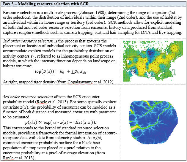
The Science: Spatial capture-recapture methods represent an extension of classical capture-recapture and allows for both the spatial organization of sampling devices and the spatial information that is inherent in essentially all studies of animal populations, i.e., spatial encounter histories. By coupling a spatio-temporal point process with a spatially explicit observation model (Figure 2), SCR has emerged as a flexible framework that allows ecologists to test hypotheses about a wide range of ecological theories including resource selection (Figure 3), landscape and network connectivity (Figure 4), demography and movement and dispersal. While classical capture-recapture methods focus on population level quantities, SCR models allow for the “downscaling” of population structure from coarse summaries (spatial and/or demographic) into finer-scale components by the use of a spatially explicit individual-based point process model.
The Future: It is possible to use SCR with individual encounter history data to inform landscape management decisions such as corridor and reserve design. Because SCR models provide spatially explicit within-population information about density, they provide objective inferences about where the population is distributed in space and why. Therefore, SCR can serve as an empirical framework for characterizing the utility of landscapes to populations. In particular, when combined with explicit models of connectivity spatially explicit metrics which integrate information about both density and connectivity (Sutherland et al. 2015; Fuller et al. 2016; Morin et al. 2016) can be estimated.
There has been considerable attention paid to the problem of uncertain identity in capture-recapture . However, such methods have developed in the context of classical capture-recapture methods which ignore the spatial information inherent in most animal population sampling studies. On the other hand, for most populations we should expect that the spatial location of samples should be informative about the uncertain identity of those samples (Augustine et al. 2016). That is, all other things being equal, spatial samples that are in close spatial proximity to one another should more likely be of the same individual than samples that are far apart. Thus, dealing effectively with an uncertain identity of an individual is fundamentally a spatial problem for which SCR offers a solution.


The Challenge: For decades, capture-recapture methods have been the cornerstone of ecological statistics as applied to population biology. While capture-recapture has become the standard sampling and analytical framework for the study of population processes (Williams, Nichols & Conroy 2002) it has advanced independent of and remained unconnected to the spatial structure of the population or the landscape within which populations exist. Furthermore, capture-recapture does not invoke any spatially explicit biological processes and thus is distinctly non-spatial, accounting neither for the inherent spatial nature of the sampling nor of the spatial distribution of individual encounters. Linking observed encounter histories of individuals to mechanisms of spatial population ecology will enable ecologists to study these processes using new technologies such as noninvasive genetics, remote cameras and bioacoustic sampling (Figure 1 under the Science Tab).
The Science: Spatial capture-recapture methods represent an extension of classical capture-recapture and allows for both the spatial organization of sampling devices and the spatial information that is inherent in essentially all studies of animal populations, i.e., spatial encounter histories. By coupling a spatio-temporal point process with a spatially explicit observation model (Figure 2), SCR has emerged as a flexible framework that allows ecologists to test hypotheses about a wide range of ecological theories including resource selection (Figure 3), landscape and network connectivity (Figure 4), demography and movement and dispersal. While classical capture-recapture methods focus on population level quantities, SCR models allow for the “downscaling” of population structure from coarse summaries (spatial and/or demographic) into finer-scale components by the use of a spatially explicit individual-based point process model.
The Future: It is possible to use SCR with individual encounter history data to inform landscape management decisions such as corridor and reserve design. Because SCR models provide spatially explicit within-population information about density, they provide objective inferences about where the population is distributed in space and why. Therefore, SCR can serve as an empirical framework for characterizing the utility of landscapes to populations. In particular, when combined with explicit models of connectivity spatially explicit metrics which integrate information about both density and connectivity (Sutherland et al. 2015; Fuller et al. 2016; Morin et al. 2016) can be estimated.
There has been considerable attention paid to the problem of uncertain identity in capture-recapture . However, such methods have developed in the context of classical capture-recapture methods which ignore the spatial information inherent in most animal population sampling studies. On the other hand, for most populations we should expect that the spatial location of samples should be informative about the uncertain identity of those samples (Augustine et al. 2016). That is, all other things being equal, spatial samples that are in close spatial proximity to one another should more likely be of the same individual than samples that are far apart. Thus, dealing effectively with an uncertain identity of an individual is fundamentally a spatial problem for which SCR offers a solution.