
Agricultural Expansion Across West Africa
West Africa is composed of a wide variety of ecosystems and an equally high number of food production systems. Agriculture is the basic driver of West Africa’s economy, on which the majority of people depend for their livelihood (Gyasi and Uitto, 1997). Most farms are small, typically 1 to 5 hectares. Although the small size of farms reflects a scarcity of land in heavily populated areas as in parts of Nigeria, it is also a result of the limited technology available to rural households (Stock, 2012).
West African agriculture ranges from nomadic pastoralism in the far north to root-crop and tree-crop systems in the south. In general, the crop-producing areas are roughly horizontal belts following bioclimatic zones (Bossard, 2009). In the Sahelian zone, millet and sorghum are the predominant crops, transitioning to maize, groundnuts, and cowpeas farther south in the Sudanian zone. These food crops are among the top five harvested crops in the Sahelian countries — Mauritania, Senegal, Mali, Burkina Faso, Niger, and Chad. Root crops such as cassava and yams are found mostly across the Guinean zone, especially in Sierra Leone, Ghana, Nigeria, and Côte d’Ivoire. Finally, tree crops such as cocoa, palm trees, or cashew trees are found in the Guineo-Congolian zone. In this humid climate, rice is also one of the most harvested crops in terms of area; it ranks first in Guinea, Liberia, and Sierra Leone. Rice is the most rapidly growing staple food in West Africa and constitutes a major part of the population’s diet. The crop production figures in the table below reflect the strong correlation of crop distribution patterns with the climate zones.

Fueled by high population growth and a growing demand for food, agricultural expansion accounts for most land cover change across West Africa. In 1975, cropland was widely scattered among the natural landscapes, covering 10.7 percent of the mapped area (see land cover maps). In the next several decades, cropland has expanded rapidly and now pervades the whole region. By 2013, the area covered by cultivated areas doubled, reaching a total of 1,100,000 sq km, or 22.4 percent of the land surface see land cover maps). In every country, agriculture has been exerting pressure on the natural landscapes, replacing and fragmenting savannas, woodlands, wetlands, and forests.
Across the Sahel, agriculture expanded into most of the suitable soils that were occupied by the natural Sahelian savanna, and cut into the traditional pastoral areas of northern Mali, Niger, and Chad. Niger’s vast south-central agricultural zone, already heavily cultivated in 1975, became fully saturated with cropland and expanded eastward into the pastoral zone. In Senegal, cropland spread into the central and southern wooded savannas and woodlands, creating a new patchwork of farmland and settlements. Meanwhile, Senegal’s Peanut Basin is also notable by the extent of cropland loss, with large areas being put into long-term fallow, mapped as savanna. This is one of the manifestations of the agriculture crisis as cultivation is abandoned, young men and women leaving the land to seek opportunities in urban areas.
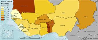
Mauritania and Togo stand out with high annual rates of agriculture expansion, 7 and 6.4 percent per year on average, respectively. Indeed, in 1975 agriculture represented only 0.2 percent of southern Mauritania, but cultivated area expanded by more than 3 times in the past four decades. In Togo, cropland, which already covered about 10 percent of the country area in 1975, was also multiplied by three — to cover 34 percent of the land by 2013. The core of agriculture expansion, however, occurred within the Sudanian zone where climate is more suited for a large variety of crops. From southwestern Senegal to southern Chad, cropland has expanded — replacing biodiverse savannas, woodlands, and gallery forests. The most dramatic change occurred in Burkina Faso where cropland became the dominant land cover, reaching 39 percent of the national area in 2013. In northern Côte d’Ivoire, Ghana, Togo, Benin, central Nigeria, and southern Chad, the pattern and extent of cropland profoundly modified and fragmented the landscape. West Africa’s Sudanian zone is rapidly transforming into human-crafted landscapes leaving scattered islands of semi-natural vegetation cover. In southern Chad, notably in the Logone Basin, cultivated areas are establishing a foothold in the savannas and woodlands.
The growing agricultural footprint appears to be slower and more scattered in the Guinean and Guineo- Congolian zones, with the exception of the southern regions of Côte d’Ivoire, Ghana, Togo, and Benin, where cropland and plantations already dominated the landscape in 1975. Togo and Benin have seen some of the fastest rates of agricultural spread; these two countries are in first and third place, respectively, in terms of average annual agricultural expansion rates between 1975 and 2013. Nigeria stands out as having the highest percentage of cultivated land in West Africa, with 41.5 percent of its land area devoted to agriculture in 2013. In the Guinean and Guineo-Congolian climate zones, which are more humid, the spread of cultivated areas has exerted great pressure on the remaining forests. Forests have become fragmented and degraded where they occur outside of protected areas.

The change in cultivated area masks an evolution in the agricultural systems as well. In the early 1970s, cash crops (coffee, cocoa, cotton, groundnuts, oil palm, and rubber) were promoted as a means of involving West African farmers in the global commercial economy and ensuring a supply of tropical products for European markets and industry (Stock, 2012). After 1975, the area devoted to cash crops continued to increase and became even larger in the late 2000s (see graph). Cash crops, however, often competed with food crops such as sorghum and millet, and per capita food production has been decreasing in the region (Stock, 2012). Across West Africa, there is a tug-of-war between the need to protect the remaining natural landscapes — biodiverse forests wooded savannas, and grazing areas important to the livelihoods of agro- pastoralists — and the need to increase agricultural output rapidly to meet increasing demand for food and fiber. In many places, the days of agricultural “extensification”are ending as arable land available to expand farming disappears. The land frontier is closing, making intensification — producing more food on the same surface area — a critical agricultural and environmental goal. Intensification can be accomplished in a way that meets food and fiber supply goals and helps the environment on-farm and off. Sustainably intensifying farmland use can also protect the commons — forests, savannas, wetlands, steppes. Degradation of farmlands and forests undermines the national economies. Protecting farmlands is thus crucial to farm productivity, and protecting the commons is crucial to maintaining biodiversity and ecosystem services on which African societies depend.
Conversion of wooded savanna to agriculture (millet and peanut, post harvest)


Landscapes of West Africa: A Window on a Changing World
West Africa is composed of a wide variety of ecosystems and an equally high number of food production systems. Agriculture is the basic driver of West Africa’s economy, on which the majority of people depend for their livelihood (Gyasi and Uitto, 1997). Most farms are small, typically 1 to 5 hectares. Although the small size of farms reflects a scarcity of land in heavily populated areas as in parts of Nigeria, it is also a result of the limited technology available to rural households (Stock, 2012).
West African agriculture ranges from nomadic pastoralism in the far north to root-crop and tree-crop systems in the south. In general, the crop-producing areas are roughly horizontal belts following bioclimatic zones (Bossard, 2009). In the Sahelian zone, millet and sorghum are the predominant crops, transitioning to maize, groundnuts, and cowpeas farther south in the Sudanian zone. These food crops are among the top five harvested crops in the Sahelian countries — Mauritania, Senegal, Mali, Burkina Faso, Niger, and Chad. Root crops such as cassava and yams are found mostly across the Guinean zone, especially in Sierra Leone, Ghana, Nigeria, and Côte d’Ivoire. Finally, tree crops such as cocoa, palm trees, or cashew trees are found in the Guineo-Congolian zone. In this humid climate, rice is also one of the most harvested crops in terms of area; it ranks first in Guinea, Liberia, and Sierra Leone. Rice is the most rapidly growing staple food in West Africa and constitutes a major part of the population’s diet. The crop production figures in the table below reflect the strong correlation of crop distribution patterns with the climate zones.
Fueled by high population growth and a growing demand for food, agricultural expansion accounts for most land cover change across West Africa. In 1975, cropland was widely scattered among the natural landscapes, covering 10.7 percent of the mapped area (see land cover maps). In the next several decades, cropland has expanded rapidly and now pervades the whole region. By 2013, the area covered by cultivated areas doubled, reaching a total of 1,100,000 sq km, or 22.4 percent of the land surface see land cover maps). In every country, agriculture has been exerting pressure on the natural landscapes, replacing and fragmenting savannas, woodlands, wetlands, and forests.
Across the Sahel, agriculture expanded into most of the suitable soils that were occupied by the natural Sahelian savanna, and cut into the traditional pastoral areas of northern Mali, Niger, and Chad. Niger’s vast south-central agricultural zone, already heavily cultivated in 1975, became fully saturated with cropland and expanded eastward into the pastoral zone. In Senegal, cropland spread into the central and southern wooded savannas and woodlands, creating a new patchwork of farmland and settlements. Meanwhile, Senegal’s Peanut Basin is also notable by the extent of cropland loss, with large areas being put into long-term fallow, mapped as savanna. This is one of the manifestations of the agriculture crisis as cultivation is abandoned, young men and women leaving the land to seek opportunities in urban areas.
Mauritania and Togo stand out with high annual rates of agriculture expansion, 7 and 6.4 percent per year on average, respectively. Indeed, in 1975 agriculture represented only 0.2 percent of southern Mauritania, but cultivated area expanded by more than 3 times in the past four decades. In Togo, cropland, which already covered about 10 percent of the country area in 1975, was also multiplied by three — to cover 34 percent of the land by 2013. The core of agriculture expansion, however, occurred within the Sudanian zone where climate is more suited for a large variety of crops. From southwestern Senegal to southern Chad, cropland has expanded — replacing biodiverse savannas, woodlands, and gallery forests. The most dramatic change occurred in Burkina Faso where cropland became the dominant land cover, reaching 39 percent of the national area in 2013. In northern Côte d’Ivoire, Ghana, Togo, Benin, central Nigeria, and southern Chad, the pattern and extent of cropland profoundly modified and fragmented the landscape. West Africa’s Sudanian zone is rapidly transforming into human-crafted landscapes leaving scattered islands of semi-natural vegetation cover. In southern Chad, notably in the Logone Basin, cultivated areas are establishing a foothold in the savannas and woodlands.
The growing agricultural footprint appears to be slower and more scattered in the Guinean and Guineo- Congolian zones, with the exception of the southern regions of Côte d’Ivoire, Ghana, Togo, and Benin, where cropland and plantations already dominated the landscape in 1975. Togo and Benin have seen some of the fastest rates of agricultural spread; these two countries are in first and third place, respectively, in terms of average annual agricultural expansion rates between 1975 and 2013. Nigeria stands out as having the highest percentage of cultivated land in West Africa, with 41.5 percent of its land area devoted to agriculture in 2013. In the Guinean and Guineo-Congolian climate zones, which are more humid, the spread of cultivated areas has exerted great pressure on the remaining forests. Forests have become fragmented and degraded where they occur outside of protected areas.
The change in cultivated area masks an evolution in the agricultural systems as well. In the early 1970s, cash crops (coffee, cocoa, cotton, groundnuts, oil palm, and rubber) were promoted as a means of involving West African farmers in the global commercial economy and ensuring a supply of tropical products for European markets and industry (Stock, 2012). After 1975, the area devoted to cash crops continued to increase and became even larger in the late 2000s (see graph). Cash crops, however, often competed with food crops such as sorghum and millet, and per capita food production has been decreasing in the region (Stock, 2012). Across West Africa, there is a tug-of-war between the need to protect the remaining natural landscapes — biodiverse forests wooded savannas, and grazing areas important to the livelihoods of agro- pastoralists — and the need to increase agricultural output rapidly to meet increasing demand for food and fiber. In many places, the days of agricultural “extensification”are ending as arable land available to expand farming disappears. The land frontier is closing, making intensification — producing more food on the same surface area — a critical agricultural and environmental goal. Intensification can be accomplished in a way that meets food and fiber supply goals and helps the environment on-farm and off. Sustainably intensifying farmland use can also protect the commons — forests, savannas, wetlands, steppes. Degradation of farmlands and forests undermines the national economies. Protecting farmlands is thus crucial to farm productivity, and protecting the commons is crucial to maintaining biodiversity and ecosystem services on which African societies depend.
Conversion of wooded savanna to agriculture (millet and peanut, post harvest)