
Annual NLCD Product Suite
Annual NLCD Land Cover product
Annual NLCD Land Cover Change product
Annual NLCD Confidence Index product
Annual NLCD Fractional Impervious Surface product
Impervious Descriptor
Annual NLCD Spectral Change Day of Year product
Annual National Land Cover Database (NLCD) Collection 1.2 includes a suite of six raster land use and land cover science products for the conterminous United States. It covers the period between 1985 and 2025. The Science Product User Guide contains in-depth background and documentation about the Annual NLCD product suite.
The Science Product User Guide contains in-depth background and documentation about the Annual NLCD product suite.
Citation
U.S. Geological Survey (USGS), 2024, Annual NLCD Collection 1 Science Products: U.S. Geological Survey data release, https://doi.org/10.5066/P94UXNTS
Annual NLCD Science Products
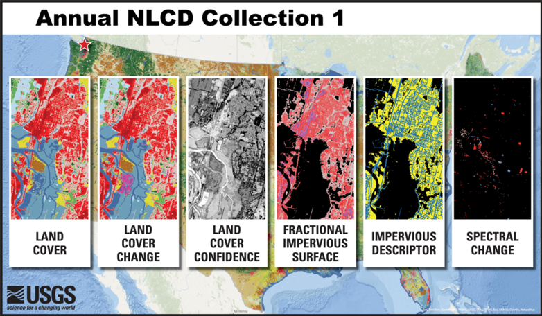
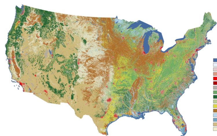
Land Cover (LndCov)
Depicts the predominant thematic land cover class within the mapping year with respect to broad categories of artificial or natural surface cover. Click here to learn more about the Land Cover product.

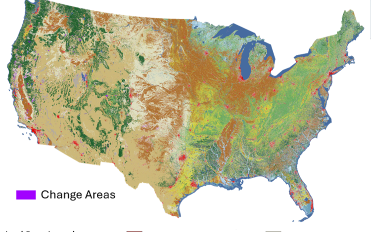
Land Cover Change (LndChg)
Depicts land cover change between one product year and the next. Changes are represented in the latter year. For more information about the Landcover Change product click here.

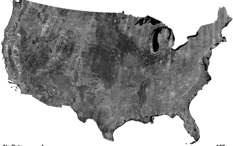
Land Cover Confidence (LndCnf)
Depicts the probability value for the land cover class derived from the classification method. To learn more about the Land Cover Confidence product click here.

Fractional Impervious Surface (FctImp)
Depicts the fractional surface area of the map unit (pixel) that is covered with artificial substrate or structures. Click here for more information about the Fractional Impervious Surface product.

Impervious Descriptor (ImpDsc)
Depicts categorical data for developed land cover distinguishing roads from urban-non-road. For more information about the Impervious Descriptor product click here.

Spectral Change Day of Year (SpcChg)
Depicts the day-of-year (DOY) on which a significant deviation in Landsat surface reflectance was detected within the calendar year. More information about the Spectral Change of Year product can be found here.

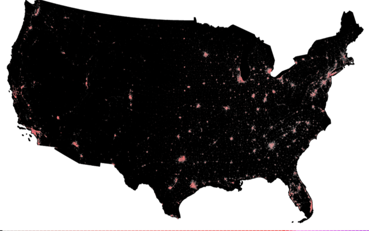
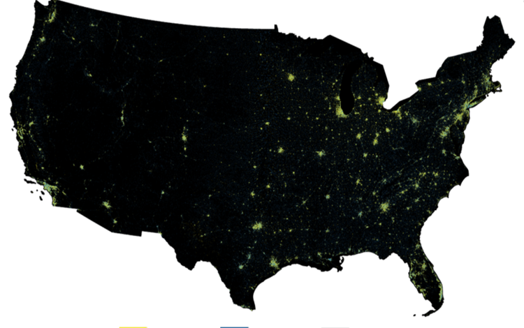

The images above show the Annual NLCD products (top from right) Land Cover, Land Cover Change, Land Cover Confidence Index, (bottom from right) Fractional Impervious Surface, Impervious Descriptor, and Spectral Change Day of Year for the lower 48 states.
Back to the Annual NLCD landing page.
Annual National Land Cover Database (NLCD) Collection 1.2 includes a suite of six raster land use and land cover science products for the conterminous United States. It covers the period between 1985 and 2025. The Science Product User Guide contains in-depth background and documentation about the Annual NLCD product suite.
The Science Product User Guide contains in-depth background and documentation about the Annual NLCD product suite.
Citation
U.S. Geological Survey (USGS), 2024, Annual NLCD Collection 1 Science Products: U.S. Geological Survey data release, https://doi.org/10.5066/P94UXNTS
Annual NLCD Science Products
Land Cover (LndCov)
Depicts the predominant thematic land cover class within the mapping year with respect to broad categories of artificial or natural surface cover. Click here to learn more about the Land Cover product.
Land Cover Change (LndChg)
Depicts land cover change between one product year and the next. Changes are represented in the latter year. For more information about the Landcover Change product click here.
Land Cover Confidence (LndCnf)
Depicts the probability value for the land cover class derived from the classification method. To learn more about the Land Cover Confidence product click here.
Fractional Impervious Surface (FctImp)
Depicts the fractional surface area of the map unit (pixel) that is covered with artificial substrate or structures. Click here for more information about the Fractional Impervious Surface product.
Impervious Descriptor (ImpDsc)
Depicts categorical data for developed land cover distinguishing roads from urban-non-road. For more information about the Impervious Descriptor product click here.
Spectral Change Day of Year (SpcChg)
Depicts the day-of-year (DOY) on which a significant deviation in Landsat surface reflectance was detected within the calendar year. More information about the Spectral Change of Year product can be found here.
The images above show the Annual NLCD products (top from right) Land Cover, Land Cover Change, Land Cover Confidence Index, (bottom from right) Fractional Impervious Surface, Impervious Descriptor, and Spectral Change Day of Year for the lower 48 states.
Back to the Annual NLCD landing page.