
Case Studies Illustrating the Unique Changes Occurring in West Africa
Below is an example of a W-ARly-Pendjari (WAP) complex ecological case study illustrating the change over 30 years. There are 29 additional case studies available that explore the distinct transformations happening in the landscapes of West Africa, with one to two studies for each country. For the complete collection, refer to the Landscapes of West Africa Atlas.
The W-Arly-Pendjari (WAP) ecological complex in West Africa is a major expanse of intact Sudano-sahelian savanna. The two core areas of the complex are the W Regional Park straddling the borders of Benin, Burkina Faso and Niger, and the Arly Total Faunal Reserve and Pendjari National Park in Burkina Faso and Benin. However, as many as 16 additional reserves, partial reserves and hunting zones surround the two core transboundary reserves, bringing the total area of the complex to roughly 32,250 sq km. While the condition and level of protection varies among the various parks and reserves, the complex nevertheless represents an extremely important contiguous body of intact West African habitat, crucial to the preservation of regional biodiversity and natural heritage (Clerici, 2007).


Between 1990 and 2015 the estimated population within a 30-km buffer surrounding all of the various designated protected areas of the complex more than doubled, from 1.67 million people to 3.52 million people (CIESIN, 2005), putting growing pressure on reserve boundaries. In the key agricultural region of northwestern Benin, food crops and a rapid expansion of cotton growing have converted the savanna landscape bordering the WAP reserve to one dominated by small holder farm fields (Kokoye and others, 2013). At the northern edge of the WAP where the Niger River forms the W shape, which gives the transboundary national park its name, dozens of new villages have appeared in recent decades. Food insecurity in the 1970s led to the decommissioning of almost half of the Tamou Total Faunal Reserve there, leading to a wave of migration to the fertile soils along the Niger floodplain. In eastern Burkina Faso, while many villages are not new (Price and others, 2002), a growing population and increasingly intense farming and cattle-raising have made the boundary between the inside and outside of the protected area a sharp unmistakable line in the 2015 satellite images.
The W-Arly-Pendjari complex is recognized internationally for its important biodiversity. Pendjari National Park in Benin in 1986 and the W National Park in Niger in 1996 were designated UNESCO Biosphere Reserves. In 2002 the Benin and Burkina Faso W National Parks were added to form the W Transboundary Biosphere Reserve (TBR) (Michelot and Ouedraogo, 2009). In 2007 the wetlands of the W TBR were designated“wetlands of international importance” under the Ramsar Convention (UNESCO, 2005). The W National Parks in Niger, the W and Pendjari Parks in Benin and the Arly, W and Singou Reserves in Burkina Faso were all designated as Important Bird Areas by Birdlife International in 2001.
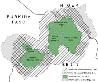
The size and structure of the WAP complex is unusual if not unique in West Africa where protected forests tend to be relatively small and suffer high levels of encroachment (Joppa and others, 2008). Following the biosphere reserve concept adopted by UNESCO, the WAP complex’s core areas of biodiversity and intact ecosystems (green areas on the map above) are protected by buffer areas and transition zones (UNESCO 1996). Nevertheless, the pressure to feed and provide livelihoods for a rapidly growing population is evident in the dramatic loss of wooded savanna and gallery forests surrounding the WAP complex’s borders.
For the W-Arly-Pendjari Complex the partial reserves and hunting zones serve as buffers for much of the core’s perimeter but do not completely encircle the core. Land cover maps from 1975, 2000 and 2013 show that within the core area of the three contiguous W National Parks, Pendjari National Park and the Arly Total Faunal Reserve, land cover has been very stable since 1975. Outside the core areas but within the partial reserves and hunting zones (gray with crosshatch), agriculture has increased from 8 percent in 1975 to 15 percent in 2013, while intact savanna decreased from 71 percent to 68 percent. In the areas outside the core and not designated as reserves or hunting zones (diagonal hatch marks), the loss of savanna was much greater. Savanna covered 70 percent of unprotected land in 1975 but just under 45 percent in 2013, as agriculture grew from 16 percent to over 44 percent.
In spite of the high levels of protection that have been established, especially for the core areas, ongoing encroachment can be seen occurring at some locations along boundaries of the reserves. The high-resolution image from July 2011 (see above) shows some farm fields that have been cleared within the bounds of W National Park, Benin. Most of this sort of encroachment occurs away from the designated hunting zones and reserves, which appear to provide effective buffers for the core parks where they have been established. It is estimated that the W Regional Park is a seasonal home to 3,800 African elephants, more than half the West African population (Clerici, 2007). Data collected from a variety of surveys taken between 2004 and 2014 sets the number of elephants in the larger complex of 19 protected areas at over 5,500 (IUCN, 2015). The WAP complex supports populations of several other large mammals including giraffe, hippopotamuses, and West African savanna buffalo, big cats such as lions, leopards, and cheetahs and a number of antelope species including roan antelope, kobs, topi, defassa waterbuck, western hartebeest, red-fronted gazelle, and oribi. The WAP complex protects hundreds of bird species, as well as many species of fish, insects and other organisms, all of which are a part of the biodiversity of this invaluable natural ecosystem.


Landscapes of West Africa: A Window on a Changing World
Below is an example of a W-ARly-Pendjari (WAP) complex ecological case study illustrating the change over 30 years. There are 29 additional case studies available that explore the distinct transformations happening in the landscapes of West Africa, with one to two studies for each country. For the complete collection, refer to the Landscapes of West Africa Atlas.
The W-Arly-Pendjari (WAP) ecological complex in West Africa is a major expanse of intact Sudano-sahelian savanna. The two core areas of the complex are the W Regional Park straddling the borders of Benin, Burkina Faso and Niger, and the Arly Total Faunal Reserve and Pendjari National Park in Burkina Faso and Benin. However, as many as 16 additional reserves, partial reserves and hunting zones surround the two core transboundary reserves, bringing the total area of the complex to roughly 32,250 sq km. While the condition and level of protection varies among the various parks and reserves, the complex nevertheless represents an extremely important contiguous body of intact West African habitat, crucial to the preservation of regional biodiversity and natural heritage (Clerici, 2007).
Between 1990 and 2015 the estimated population within a 30-km buffer surrounding all of the various designated protected areas of the complex more than doubled, from 1.67 million people to 3.52 million people (CIESIN, 2005), putting growing pressure on reserve boundaries. In the key agricultural region of northwestern Benin, food crops and a rapid expansion of cotton growing have converted the savanna landscape bordering the WAP reserve to one dominated by small holder farm fields (Kokoye and others, 2013). At the northern edge of the WAP where the Niger River forms the W shape, which gives the transboundary national park its name, dozens of new villages have appeared in recent decades. Food insecurity in the 1970s led to the decommissioning of almost half of the Tamou Total Faunal Reserve there, leading to a wave of migration to the fertile soils along the Niger floodplain. In eastern Burkina Faso, while many villages are not new (Price and others, 2002), a growing population and increasingly intense farming and cattle-raising have made the boundary between the inside and outside of the protected area a sharp unmistakable line in the 2015 satellite images.
The W-Arly-Pendjari complex is recognized internationally for its important biodiversity. Pendjari National Park in Benin in 1986 and the W National Park in Niger in 1996 were designated UNESCO Biosphere Reserves. In 2002 the Benin and Burkina Faso W National Parks were added to form the W Transboundary Biosphere Reserve (TBR) (Michelot and Ouedraogo, 2009). In 2007 the wetlands of the W TBR were designated“wetlands of international importance” under the Ramsar Convention (UNESCO, 2005). The W National Parks in Niger, the W and Pendjari Parks in Benin and the Arly, W and Singou Reserves in Burkina Faso were all designated as Important Bird Areas by Birdlife International in 2001.
The size and structure of the WAP complex is unusual if not unique in West Africa where protected forests tend to be relatively small and suffer high levels of encroachment (Joppa and others, 2008). Following the biosphere reserve concept adopted by UNESCO, the WAP complex’s core areas of biodiversity and intact ecosystems (green areas on the map above) are protected by buffer areas and transition zones (UNESCO 1996). Nevertheless, the pressure to feed and provide livelihoods for a rapidly growing population is evident in the dramatic loss of wooded savanna and gallery forests surrounding the WAP complex’s borders.
For the W-Arly-Pendjari Complex the partial reserves and hunting zones serve as buffers for much of the core’s perimeter but do not completely encircle the core. Land cover maps from 1975, 2000 and 2013 show that within the core area of the three contiguous W National Parks, Pendjari National Park and the Arly Total Faunal Reserve, land cover has been very stable since 1975. Outside the core areas but within the partial reserves and hunting zones (gray with crosshatch), agriculture has increased from 8 percent in 1975 to 15 percent in 2013, while intact savanna decreased from 71 percent to 68 percent. In the areas outside the core and not designated as reserves or hunting zones (diagonal hatch marks), the loss of savanna was much greater. Savanna covered 70 percent of unprotected land in 1975 but just under 45 percent in 2013, as agriculture grew from 16 percent to over 44 percent.
In spite of the high levels of protection that have been established, especially for the core areas, ongoing encroachment can be seen occurring at some locations along boundaries of the reserves. The high-resolution image from July 2011 (see above) shows some farm fields that have been cleared within the bounds of W National Park, Benin. Most of this sort of encroachment occurs away from the designated hunting zones and reserves, which appear to provide effective buffers for the core parks where they have been established. It is estimated that the W Regional Park is a seasonal home to 3,800 African elephants, more than half the West African population (Clerici, 2007). Data collected from a variety of surveys taken between 2004 and 2014 sets the number of elephants in the larger complex of 19 protected areas at over 5,500 (IUCN, 2015). The WAP complex supports populations of several other large mammals including giraffe, hippopotamuses, and West African savanna buffalo, big cats such as lions, leopards, and cheetahs and a number of antelope species including roan antelope, kobs, topi, defassa waterbuck, western hartebeest, red-fronted gazelle, and oribi. The WAP complex protects hundreds of bird species, as well as many species of fish, insects and other organisms, all of which are a part of the biodiversity of this invaluable natural ecosystem.