
Case Study: Land Cover Modification
This work presents West Africa’s changing landscapes through land use and land cover maps for three periods in time. The changes between each period represent one of two main types of landscape change: land cover conversions and land cover modifications.

Land cover conversions are the transitions from one land cover or use type to another (e.g., forest to agriculture). As the maps show this type of change can be quite dramatic, such as the loss and fragmentation of the Upper Guinean forest.
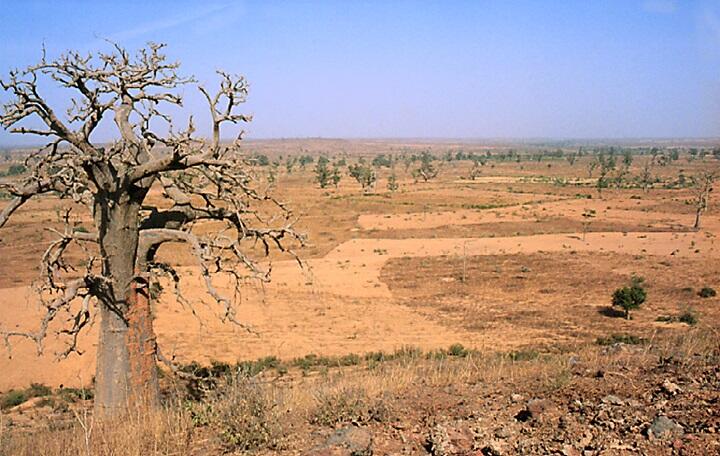
In land cover modification, the general land cover or use type does not change, but there is a change in its attributes. This type of change is more subtle but can be very significant. An example is the effect of logging in a woodland: the land cover is still “woodland,” but its quality — the tree density and biodiversity — has been diminished by selective tree harvesting. Assessing these more subtle land cover modifications generally requires high resolution imagery. For example, most of the loss in woody biomass found in the various types of vegetation cover in Senegal were a result of land cover modification rather than the conversion of land cover from one class to another (Woomer and others, 2004; Tappan and others, 2004). Land cover modification is much harder to map and quantify at national and regional levels than land cover conversion. The recent, widespread availability of high-resolution imagery is helping environmental scientists gain a more complete picture of land cover modification in West Africa.
Land cover modification is clearly seen in the pairs of satellite images below, which compare two Sahelian landscapes in northern Senegal at a time interval of 38 and 51 years. The first pair (top images) shows a relatively dense tree savanna on a sandy plain in December 1965 (Corona, left). The May 2003 image (DigitalGlobe, right) shows that the same landscape has become an open tree savanna. This area experienced high tree mortality during the droughts of the 1970s and 1980s, exacerbated by increased browsing by livestock as grass cover became scarce. The Ferlo Valley was dry in 1965 (left image) but began to flood in 1988 when the Diama Dam was constructed on the Senegal River.

The second pair (below) shows land cover modification on a more complex landscape that evolved from ancient sand dunes. This example is also from northern Senegal, 25 km southeast of Dagana. In December 1965 (Corona, left) trees (black points) are scattered throughout continuous grass cover, with clusters of trees forming wooded stands in many small natural depressions. Half a century later, the 2016 image (DigitalGlobe, right) shows that most of the trees have disappeared — also from drought and livestock pressure — except in the wooded depressions where water collects during the brief rainy season. A seasonal camp of semi-nomadic Fulani herders is visible in the upper left quarter of the image. The stark contrast between wooded depressions and the surrounding open country has increased with time — a typical phenomenon in many landscapes across the Sahel.

Land modification, however, is not always negative. Across West Africa, many examples of positive land modification, such as the regeneration of woody cover, the increase of biodiversity on cropland, or the use of soil and water conservation practices to improve cropland productivity, can be cited (see examples below, and cases of land restoration).
Comparative views of the same landscape in central Senegal 1994 and 2010 showing the regeneration of woody cover after years of harvesting shrubs and trees for wood fuels.


Landscapes of West Africa: A Window on a Changing World
This work presents West Africa’s changing landscapes through land use and land cover maps for three periods in time. The changes between each period represent one of two main types of landscape change: land cover conversions and land cover modifications.
Land cover conversions are the transitions from one land cover or use type to another (e.g., forest to agriculture). As the maps show this type of change can be quite dramatic, such as the loss and fragmentation of the Upper Guinean forest.
In land cover modification, the general land cover or use type does not change, but there is a change in its attributes. This type of change is more subtle but can be very significant. An example is the effect of logging in a woodland: the land cover is still “woodland,” but its quality — the tree density and biodiversity — has been diminished by selective tree harvesting. Assessing these more subtle land cover modifications generally requires high resolution imagery. For example, most of the loss in woody biomass found in the various types of vegetation cover in Senegal were a result of land cover modification rather than the conversion of land cover from one class to another (Woomer and others, 2004; Tappan and others, 2004). Land cover modification is much harder to map and quantify at national and regional levels than land cover conversion. The recent, widespread availability of high-resolution imagery is helping environmental scientists gain a more complete picture of land cover modification in West Africa.
Land cover modification is clearly seen in the pairs of satellite images below, which compare two Sahelian landscapes in northern Senegal at a time interval of 38 and 51 years. The first pair (top images) shows a relatively dense tree savanna on a sandy plain in December 1965 (Corona, left). The May 2003 image (DigitalGlobe, right) shows that the same landscape has become an open tree savanna. This area experienced high tree mortality during the droughts of the 1970s and 1980s, exacerbated by increased browsing by livestock as grass cover became scarce. The Ferlo Valley was dry in 1965 (left image) but began to flood in 1988 when the Diama Dam was constructed on the Senegal River.
The second pair (below) shows land cover modification on a more complex landscape that evolved from ancient sand dunes. This example is also from northern Senegal, 25 km southeast of Dagana. In December 1965 (Corona, left) trees (black points) are scattered throughout continuous grass cover, with clusters of trees forming wooded stands in many small natural depressions. Half a century later, the 2016 image (DigitalGlobe, right) shows that most of the trees have disappeared — also from drought and livestock pressure — except in the wooded depressions where water collects during the brief rainy season. A seasonal camp of semi-nomadic Fulani herders is visible in the upper left quarter of the image. The stark contrast between wooded depressions and the surrounding open country has increased with time — a typical phenomenon in many landscapes across the Sahel.
Land modification, however, is not always negative. Across West Africa, many examples of positive land modification, such as the regeneration of woody cover, the increase of biodiversity on cropland, or the use of soil and water conservation practices to improve cropland productivity, can be cited (see examples below, and cases of land restoration).
Comparative views of the same landscape in central Senegal 1994 and 2010 showing the regeneration of woody cover after years of harvesting shrubs and trees for wood fuels.