
New tree-ring science demonstrates successful restoration of historical fire patterns in two southwestern wilderness areas
Increasing modern fire is occurring against the backdrop of a large fire deficit created by fire exclusion since circa 1900. In a new study, researchers describe and apply new tree-ring methods to ask whether historically frequent fire regimes can be restored in two Southwest wilderness areas.
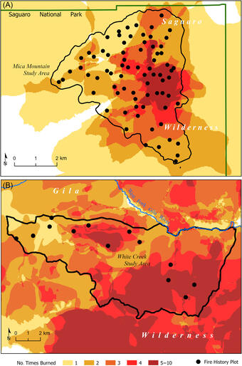
Researchers found that networks of tree-ring fire-scar sites can accurately reconstruct the area burned of mapped modern fires.
Multi-century tree-ring reconstructions of annual area burned revealed that modern area burned is back within the historical range of variability in the Gila Wilderness and trending toward historical levels in Saguaro National Park.
These results demonstrate that fire management, including prescribed fire and managed wildfires, can help restore the historically prevalent, ecologically important process of widespread, frequent, low-to-moderate-severity fire in dry conifer forests.
Related

New Mexico Tree-Ring Science

The New Mexico Landscapes Field Station

New Mexico Landscapes Field Station: Fire Research
Related
New Mexico Tree-Ring Science
The New Mexico Landscapes Field Station