
Monitoring Consumptive Water Use for Global Crop Production
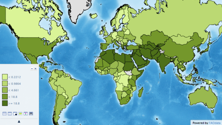
Monitoring consumptive water use is an important component of global agricultural monitoring (Curt Reynolds, USDA FAS, written commun. and oral commun., 2014), as a majority of global production relies at least in part on irrigation for crop production (fig. 1). Globally, irrigated agriculture supports production of about half of the world’s food supply (Thenkabail and others, 2010). In the United States (U.S.), agriculture accounts for around 80 percent of consumptive water, reaching upwards of 90 percent in many western states (USDA Economic Research Service, 2014).
Authors: Colin Leslie and Larisa Serbina, Contact: Holly Miller
In order to provide timely information on the agricultural economy, products and issues in foreign countries, the USDA’s Global Agricultural Information Network (GAIN) relies on U.S. Foreign Service officers stationed overseas to continuously assess and report the agricultural situation of more than 130 countries globally (USDA Foreign Agricultural Service). These Attaché Reports, rely in part on monitoring water use and availability within the region to help assess and forecast agricultural production. Landsat’s frequent collection of moderate resolution thermal imagery provides an effective means for measuring evapotranspiration, the combination of evaporation and transpiration, over a broad geographic area. The frequent assessment of water resources by satellite imagery can provide early detection of potential issues, such as drought, and is therefore an essential component of a global food security monitoring system (Anderson and others, 2012).
Landsat thermal imagery can also be used to measure evapotranspiration at the field level (fig. 2), which is particularly important in the U.S. where water use and water rights are increasingly valuable commodities (Western States Water Council, 2012). Monitoring evapotranspiration can also provide indications of water stress, such as drought, which can have a significant impact on crop yield, potentially wiping out an entire season of crop production (Jackson and others, 2004).

Benefits and Challenges of Using Landsat Imagery
Monitoring field-level consumptive water use is becoming an increasingly important consideration among agricultural and water managers (Serbina and Miller, 2014; Western States Water Council 2012). Currently, Landsat provides the only continuously collected, publically available thermal imagery of sufficient resolution to monitor consumptive water use at the field level. While the capability of Landsat to provide data for development of individual products such as NDVI or evapotranspiration is important, the ability to collect data for multiple products concurrently is also important. By collecting a single, multi-spectral image, derivative products representing a range of environmental variables allows for temporally relevant comparison among products. Additionally, the known stability of spectral and spatial resolution across Landsat satellites, as well as the high level of image-data orthorectification and radiometric correction, have helped establish Landsat as a gold standard among earth observation satellites. In practical terms, the availability of consistently collected (across multiple satellites/years), accurately corrected, and as of 2008, freely available, Landsat data is an important benefit for agencies that remain primarily operational in nature with limited time and budget for purchasing satellite imagery from commercial sources.
The recent launch of Landsat 8 in 2013 has helped ensure the continuity of the Landsat mission. However, between 2003 and 2013, the primary challenges facing agencies like the USDA were uncertainty in the long-term outlook of the Landsat program and the pending data gap due to an aging Landsat 5 and SLC-off issue with Landsat 7 (Johnson and Mueller, 2010). Although Landsat 8 became fully operational in 2013, some challenges related to agricultural monitoring remain. The primary challenge is low global repeat frequency, which continues to contribute to data gaps for global consumptive water use monitoring. Occlusion of the land surface by clouds, such as over Brazil’s soybean region bordering the Amazon forest or for the Ethiopian Highlands, remains the main challenge, where generally only one cloud-free image is acquired per year. Ethiopia remains one of the largest U.S. food aid recipients and therefore of high interest for crop production monitoring, while Brazil has become one of the largest soybean producers in the world. While the concurrence of agricultural production with high rainfall means occlusion by clouds, prioritization of agricultural monitoring needs within the Landsat 8 Long Term Acquisition Plan could potentially increase the number of usable Landsat images obtained within major agricultural regions worldwide (Curt Reynolds, USDA FAS, written commun. and oral commun., 2014).
References
Anderson, M., Allen, R., Morse, A., and Kustas.,W., 2012, Use of Landsat thermal imagery in monitoring evapotranspiration and managing water resources: Remote Sensing of Environment, v. 122, July, p. 50–65. doi:10.1016/j.rse.2011.08.025.
Jackson, T., Chen, D., Cosh, M., Li, F., Anderson, M., Walthall, C., Doriaswamy, P., and Hunt, E., 2004, Vegetation water content mapping using Landsat data derived normalized difference water index for corn and soybeans: Remote Sensing of Environment, v. 92, no. 4, p. 475–82. doi:10.1016/j.rse.2003.10.021.
USDA Economic Research Service [2013], Irrigation & Water Use: USDA Economic Research Service Web page, accessed September 8, 2014, at http://www.ers.usda.gov/topics/farm-practices-management/irrigation-wat…
USDA Foreign Agricultural Service, Global Agricultural Information Network: USDA Foreign Agricultural Service Web page, accessed July 1, 2015, at http://gain.fas.usda.gov/Pages/Default.aspx
Western States Water Council, 2012, The Landsat program and water resources information needs in the United States. Accessed at http://www.kimberly.uidaho.edu/water/metric/Essential_Specifications_fo….

Case Studies of Landsat Imagery Use
Monitoring consumptive water use is an important component of global agricultural monitoring (Curt Reynolds, USDA FAS, written commun. and oral commun., 2014), as a majority of global production relies at least in part on irrigation for crop production (fig. 1). Globally, irrigated agriculture supports production of about half of the world’s food supply (Thenkabail and others, 2010). In the United States (U.S.), agriculture accounts for around 80 percent of consumptive water, reaching upwards of 90 percent in many western states (USDA Economic Research Service, 2014).
Authors: Colin Leslie and Larisa Serbina, Contact: Holly Miller
In order to provide timely information on the agricultural economy, products and issues in foreign countries, the USDA’s Global Agricultural Information Network (GAIN) relies on U.S. Foreign Service officers stationed overseas to continuously assess and report the agricultural situation of more than 130 countries globally (USDA Foreign Agricultural Service). These Attaché Reports, rely in part on monitoring water use and availability within the region to help assess and forecast agricultural production. Landsat’s frequent collection of moderate resolution thermal imagery provides an effective means for measuring evapotranspiration, the combination of evaporation and transpiration, over a broad geographic area. The frequent assessment of water resources by satellite imagery can provide early detection of potential issues, such as drought, and is therefore an essential component of a global food security monitoring system (Anderson and others, 2012).
Landsat thermal imagery can also be used to measure evapotranspiration at the field level (fig. 2), which is particularly important in the U.S. where water use and water rights are increasingly valuable commodities (Western States Water Council, 2012). Monitoring evapotranspiration can also provide indications of water stress, such as drought, which can have a significant impact on crop yield, potentially wiping out an entire season of crop production (Jackson and others, 2004).
Benefits and Challenges of Using Landsat Imagery
Monitoring field-level consumptive water use is becoming an increasingly important consideration among agricultural and water managers (Serbina and Miller, 2014; Western States Water Council 2012). Currently, Landsat provides the only continuously collected, publically available thermal imagery of sufficient resolution to monitor consumptive water use at the field level. While the capability of Landsat to provide data for development of individual products such as NDVI or evapotranspiration is important, the ability to collect data for multiple products concurrently is also important. By collecting a single, multi-spectral image, derivative products representing a range of environmental variables allows for temporally relevant comparison among products. Additionally, the known stability of spectral and spatial resolution across Landsat satellites, as well as the high level of image-data orthorectification and radiometric correction, have helped establish Landsat as a gold standard among earth observation satellites. In practical terms, the availability of consistently collected (across multiple satellites/years), accurately corrected, and as of 2008, freely available, Landsat data is an important benefit for agencies that remain primarily operational in nature with limited time and budget for purchasing satellite imagery from commercial sources.
The recent launch of Landsat 8 in 2013 has helped ensure the continuity of the Landsat mission. However, between 2003 and 2013, the primary challenges facing agencies like the USDA were uncertainty in the long-term outlook of the Landsat program and the pending data gap due to an aging Landsat 5 and SLC-off issue with Landsat 7 (Johnson and Mueller, 2010). Although Landsat 8 became fully operational in 2013, some challenges related to agricultural monitoring remain. The primary challenge is low global repeat frequency, which continues to contribute to data gaps for global consumptive water use monitoring. Occlusion of the land surface by clouds, such as over Brazil’s soybean region bordering the Amazon forest or for the Ethiopian Highlands, remains the main challenge, where generally only one cloud-free image is acquired per year. Ethiopia remains one of the largest U.S. food aid recipients and therefore of high interest for crop production monitoring, while Brazil has become one of the largest soybean producers in the world. While the concurrence of agricultural production with high rainfall means occlusion by clouds, prioritization of agricultural monitoring needs within the Landsat 8 Long Term Acquisition Plan could potentially increase the number of usable Landsat images obtained within major agricultural regions worldwide (Curt Reynolds, USDA FAS, written commun. and oral commun., 2014).
References
Anderson, M., Allen, R., Morse, A., and Kustas.,W., 2012, Use of Landsat thermal imagery in monitoring evapotranspiration and managing water resources: Remote Sensing of Environment, v. 122, July, p. 50–65. doi:10.1016/j.rse.2011.08.025.
Jackson, T., Chen, D., Cosh, M., Li, F., Anderson, M., Walthall, C., Doriaswamy, P., and Hunt, E., 2004, Vegetation water content mapping using Landsat data derived normalized difference water index for corn and soybeans: Remote Sensing of Environment, v. 92, no. 4, p. 475–82. doi:10.1016/j.rse.2003.10.021.
USDA Economic Research Service [2013], Irrigation & Water Use: USDA Economic Research Service Web page, accessed September 8, 2014, at http://www.ers.usda.gov/topics/farm-practices-management/irrigation-wat…
USDA Foreign Agricultural Service, Global Agricultural Information Network: USDA Foreign Agricultural Service Web page, accessed July 1, 2015, at http://gain.fas.usda.gov/Pages/Default.aspx
Western States Water Council, 2012, The Landsat program and water resources information needs in the United States. Accessed at http://www.kimberly.uidaho.edu/water/metric/Essential_Specifications_fo….