
Climate Impact Meteorological Stations (CLIM-MET) Data and Repeat Photography
Meteorological measurements support studies of processes and deposits and provide calibration of regional and sub-regional change-detection mapping of vegetation and aeolian deposits using remote-sensing techniques.
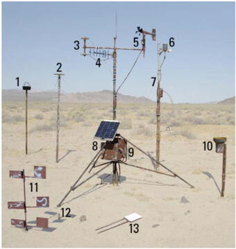
The CLIM-MET stations are meteorological/geological stations that are designed to function in remote areas for long periods of time without human intervention. These stations measure meteorological and wind-erosion parameters under varying climatic and land-use conditions to detect and describe ongoing landscape changes. Combined with historic and other data, CLIM-MET data can provide inputs into regional climatic models that describe how the Southwest will respond to future climatic conditions.
Twice a year repeat photographs are taken at each of the seven CLIM-MET sites, once in the spring and once in the fall. Starting from a predetermined point, photos are taken in a 360-degree panorama, showing the site, vegetation and surrounding landscape for that season. In addition to the panoramic site photos, photos are taken of the Sensit instrument, BSNE sediment sampler, and a brick, which is used to characterize surface changes.
Canyonlands National Park in Utah has sites at Virginia Park, Needles, Dugout Ranch, and Corral Pocket. Aeolian activity varies greatly at these four sites in and near Canyonlands National Park having different land-use histories. Two sites are currently grazed and most wind erosion occurs at one of them. Extreme drought in the region during 2002 greatly exacerbated vegetation loss, wind erosion, and dust-event frequency at this site.
Mojave National Preserve in California has sites at North Soda Lake, Balch, and Crucero. All three meteorological stations are located in the in the vicinity of Soda Lake. These stations record standard meteorological parameters along with wind-erosion data and include two kinds of traps for aeolian (wind-blown) sediment. The stations are located in three distinctive geomorphic settings, each scoured by wind: one site (North Soda Lake) near the playa margin on a shallow-gradient slope that carries sheet wash during rare flooding, a second site near a small but periodically active wash (Balch), and the third site (Crucero) in the broad outwash of the Mojave River. At each site small coppice dunes are common, and surficial deposits in the top 15 cm are dominantly sandy (typically greater than 80 percent sand). Deposits between dunes and in washes commonly have higher silt/clay content (20 to 50 percent).
ASCII Data Information
Data Storage
Data are stored in the datalogger's internal 124k memory as samples are taken (at 1 second intervals.) At the end of a measurement period (this is currently 1 hour) the data are processed and written to final storage within the datalogger memory and to an external 716k or 4 MB storage module.
Some of the data are converted to engineering units (example: °C) by datalogger software before storage, and other data (from sensor types whose calibrations differ from instrument to instrument) are stored unconverted (as a voltage for example). This is done so instruments that require unique calibrations can be replaced in the field without the necessity of changing calibrations within the datalogger software. These calibrations are then applied in the office after the data are retrieved.
Standard Data Retrieval
Data are retrieved by disconnecting the storage module from the datalogger, and replacing it with another. The removed module then can be taken to a field office where the data is downloaded, or can be mailed to a central location to be downloaded. The module contains a lithium battery that maintains power and keeps the data intact. Data retrieval software (Campbell Scientific) is used to copy data from the module. The data are read from the module, converted to comma delimited ASCII, and stored to another medium or hard drive. Once the copied data are confirmed as good, the module is erased and is ready to be used again. This operation takes only a few minutes.
Radio Telemetry Retrieval
Mojave sites transmit data to a field - base station computer via a system of 900 MHz radio transceivers. Data at these sites is written to external storage modules as well.
The datalogger at each site is connected to a radio transceiver and antenna. There is also one transceiver and antenna connected to a computer at a local desert studies center. Software on this computer makes scheduled connections to the sites in the field via radio transmission. The data is collected and stored on the computer. The data are then transmitted to the USGS home office through an automated ftp server and satellite internet service. This system allows researchers to access the data in near real time.
Next, the data is read into a custom data processing package (written in MATLAB).
Data Format and description: Explanation of CLIM-MET Site Data
All sensors are monitored every 4 seconds with the exception of soil moisture which is sampled once per hour. The 4 second resolution measurements are averaged and saved once per hour.
These sites also store higher resolution data (at 5-minute intervals) when either, or both of two conditions occur:
1. The average wind speed for that 5-minute period is above a threshold where it is believed saltation might occur.
2. The sensit erosion monitor has had a particle or particles strike it during that 5- minute period.
This allows a closer examination of the conditions occurring during saltation events. These data are stored in a separate file and are not continuously stored (not a contiguous file). For a given period of time this data file can then be very large or very small depending upon how many saltation events may have (or not have) occurred.
Data from each site is available in several processed resolutions including: Annual, Monthly, Daily, Hourly and 5-minute averages.
Site Information
Each data file has a "metadata" header similar to the text below. Please read and acknowledge use of the data accordingly.
USGS/CLIM-MET site code: SWxxx
USGS/CLIM-MET site name: xxx
latitude: xxx
longitude: xxx
elevation: xxx
install_date: xxx
Definitions
YR: Year of Data Collection
DOY: Julian Day-Of-Year
Hr: Mountain or Pacific Daylight Time
Uspd: Windspeed in m/s
Udir: Wind direction in degrees
Tgrad: Air Temperature Gradient (°C)
SenPC: Total Sensit Particle Count
SenKE: Total Sensit Kinetic Energy Count
Smost: Soil Moisture %
PeakUspd: Peak Windspeed m/s
PeakTime: Peak Windspeed Time
So_d: Downwelling Shortwave Flux (W/m2)
So_u: Upwelling Shortwave Flux (W/m2)
Tair: Air Temperature 3-m above surface (°C)
RH: Relative Humidity %
Tg: Ground Temperature 10-cm below surface (°C)
Rain: Rainfall mm/hour
Alb: Albedo
-999: (data were missing or bad)
NaN: (data were missing or bad)
*Variable Names With Added "2" identifier are 5-minute resolution data*
Repeat Photography
Twice a year repeat photographs are taken at each of the seven CLIM-MET sites, once in the spring and once in the fall. Starting from a predetermined point, photos are taken in a 360-degree panorama, showing the site, vegetation and surrounding landscape for that season. In addition to the panoramic site photos, photos are taken of the Sensit instrument, BSNE sediment sampler, and a brick, which is used to characterize surface changes. Occasionally, general independent site photos are taken.
The photos are in compressed zip files, one for each study area and season. Each season contains either all of the Mojave Desert sites (North Soda Lake, Balch and Crucero) or the Canyonlands area sites (Virginia Park, Needles Residence, Dugout Ranch, and Corral Pocket).
Photos are labeled with the site number first, where 02 = Virginia Park, 03 = Needles Residence, 04 = Dugout Ranch, 05 = North Soda Lake, 06 = Balch, 07 = Crucero, and 08 = Corral Pocket. After the site number, the date is displayed in the mm-dd-yy format. Finally, a number or set of letters follows the site number and date. In the case of the numerals they indicate the number of the photo as it was taken in the panoramic sequence. The letter codes indicate the various instruments at the site, with BS = BSNE, BR = Brick, SN = Sensit, and GEN = General site photos. For example 03_09-10-04_SN is the Sensit photo for the Needles site taken on September 10, 2004.
Disclaimer
Although this data has been processed successfully on a computer system at the U.S. Geological Survey (USGS), no warranty expressed or implied is made regarding the display or utility of the data on any other system or for general or scientific purposes, nor shall the act of distribution constitute any such warranty. The USGS or the U.S. Government shall not be held liable for improper or incorrect use of the data described and/or contained herein.
Meteorological measurements support studies of processes and deposits and provide calibration of regional and sub-regional change-detection mapping of vegetation and aeolian deposits using remote-sensing techniques.
The CLIM-MET stations are meteorological/geological stations that are designed to function in remote areas for long periods of time without human intervention. These stations measure meteorological and wind-erosion parameters under varying climatic and land-use conditions to detect and describe ongoing landscape changes. Combined with historic and other data, CLIM-MET data can provide inputs into regional climatic models that describe how the Southwest will respond to future climatic conditions.
Twice a year repeat photographs are taken at each of the seven CLIM-MET sites, once in the spring and once in the fall. Starting from a predetermined point, photos are taken in a 360-degree panorama, showing the site, vegetation and surrounding landscape for that season. In addition to the panoramic site photos, photos are taken of the Sensit instrument, BSNE sediment sampler, and a brick, which is used to characterize surface changes.
Canyonlands National Park in Utah has sites at Virginia Park, Needles, Dugout Ranch, and Corral Pocket. Aeolian activity varies greatly at these four sites in and near Canyonlands National Park having different land-use histories. Two sites are currently grazed and most wind erosion occurs at one of them. Extreme drought in the region during 2002 greatly exacerbated vegetation loss, wind erosion, and dust-event frequency at this site.
Mojave National Preserve in California has sites at North Soda Lake, Balch, and Crucero. All three meteorological stations are located in the in the vicinity of Soda Lake. These stations record standard meteorological parameters along with wind-erosion data and include two kinds of traps for aeolian (wind-blown) sediment. The stations are located in three distinctive geomorphic settings, each scoured by wind: one site (North Soda Lake) near the playa margin on a shallow-gradient slope that carries sheet wash during rare flooding, a second site near a small but periodically active wash (Balch), and the third site (Crucero) in the broad outwash of the Mojave River. At each site small coppice dunes are common, and surficial deposits in the top 15 cm are dominantly sandy (typically greater than 80 percent sand). Deposits between dunes and in washes commonly have higher silt/clay content (20 to 50 percent).
ASCII Data Information
Data Storage
Data are stored in the datalogger's internal 124k memory as samples are taken (at 1 second intervals.) At the end of a measurement period (this is currently 1 hour) the data are processed and written to final storage within the datalogger memory and to an external 716k or 4 MB storage module.
Some of the data are converted to engineering units (example: °C) by datalogger software before storage, and other data (from sensor types whose calibrations differ from instrument to instrument) are stored unconverted (as a voltage for example). This is done so instruments that require unique calibrations can be replaced in the field without the necessity of changing calibrations within the datalogger software. These calibrations are then applied in the office after the data are retrieved.
Standard Data Retrieval
Data are retrieved by disconnecting the storage module from the datalogger, and replacing it with another. The removed module then can be taken to a field office where the data is downloaded, or can be mailed to a central location to be downloaded. The module contains a lithium battery that maintains power and keeps the data intact. Data retrieval software (Campbell Scientific) is used to copy data from the module. The data are read from the module, converted to comma delimited ASCII, and stored to another medium or hard drive. Once the copied data are confirmed as good, the module is erased and is ready to be used again. This operation takes only a few minutes.
Radio Telemetry Retrieval
Mojave sites transmit data to a field - base station computer via a system of 900 MHz radio transceivers. Data at these sites is written to external storage modules as well.
The datalogger at each site is connected to a radio transceiver and antenna. There is also one transceiver and antenna connected to a computer at a local desert studies center. Software on this computer makes scheduled connections to the sites in the field via radio transmission. The data is collected and stored on the computer. The data are then transmitted to the USGS home office through an automated ftp server and satellite internet service. This system allows researchers to access the data in near real time.
Next, the data is read into a custom data processing package (written in MATLAB).
Data Format and description: Explanation of CLIM-MET Site Data
All sensors are monitored every 4 seconds with the exception of soil moisture which is sampled once per hour. The 4 second resolution measurements are averaged and saved once per hour.
These sites also store higher resolution data (at 5-minute intervals) when either, or both of two conditions occur:
1. The average wind speed for that 5-minute period is above a threshold where it is believed saltation might occur.
2. The sensit erosion monitor has had a particle or particles strike it during that 5- minute period.
This allows a closer examination of the conditions occurring during saltation events. These data are stored in a separate file and are not continuously stored (not a contiguous file). For a given period of time this data file can then be very large or very small depending upon how many saltation events may have (or not have) occurred.
Data from each site is available in several processed resolutions including: Annual, Monthly, Daily, Hourly and 5-minute averages.
Site Information
Each data file has a "metadata" header similar to the text below. Please read and acknowledge use of the data accordingly.
USGS/CLIM-MET site code: SWxxx
USGS/CLIM-MET site name: xxx
latitude: xxx
longitude: xxx
elevation: xxx
install_date: xxx
Definitions
YR: Year of Data Collection
DOY: Julian Day-Of-Year
Hr: Mountain or Pacific Daylight Time
Uspd: Windspeed in m/s
Udir: Wind direction in degrees
Tgrad: Air Temperature Gradient (°C)
SenPC: Total Sensit Particle Count
SenKE: Total Sensit Kinetic Energy Count
Smost: Soil Moisture %
PeakUspd: Peak Windspeed m/s
PeakTime: Peak Windspeed Time
So_d: Downwelling Shortwave Flux (W/m2)
So_u: Upwelling Shortwave Flux (W/m2)
Tair: Air Temperature 3-m above surface (°C)
RH: Relative Humidity %
Tg: Ground Temperature 10-cm below surface (°C)
Rain: Rainfall mm/hour
Alb: Albedo
-999: (data were missing or bad)
NaN: (data were missing or bad)
*Variable Names With Added "2" identifier are 5-minute resolution data*
Repeat Photography
Twice a year repeat photographs are taken at each of the seven CLIM-MET sites, once in the spring and once in the fall. Starting from a predetermined point, photos are taken in a 360-degree panorama, showing the site, vegetation and surrounding landscape for that season. In addition to the panoramic site photos, photos are taken of the Sensit instrument, BSNE sediment sampler, and a brick, which is used to characterize surface changes. Occasionally, general independent site photos are taken.
The photos are in compressed zip files, one for each study area and season. Each season contains either all of the Mojave Desert sites (North Soda Lake, Balch and Crucero) or the Canyonlands area sites (Virginia Park, Needles Residence, Dugout Ranch, and Corral Pocket).
Photos are labeled with the site number first, where 02 = Virginia Park, 03 = Needles Residence, 04 = Dugout Ranch, 05 = North Soda Lake, 06 = Balch, 07 = Crucero, and 08 = Corral Pocket. After the site number, the date is displayed in the mm-dd-yy format. Finally, a number or set of letters follows the site number and date. In the case of the numerals they indicate the number of the photo as it was taken in the panoramic sequence. The letter codes indicate the various instruments at the site, with BS = BSNE, BR = Brick, SN = Sensit, and GEN = General site photos. For example 03_09-10-04_SN is the Sensit photo for the Needles site taken on September 10, 2004.
Disclaimer
Although this data has been processed successfully on a computer system at the U.S. Geological Survey (USGS), no warranty expressed or implied is made regarding the display or utility of the data on any other system or for general or scientific purposes, nor shall the act of distribution constitute any such warranty. The USGS or the U.S. Government shall not be held liable for improper or incorrect use of the data described and/or contained herein.