
At the Idaho National Laboratory Project Office (INLPO), we employ advanced numerical models to enhance our understanding of groundwater flow and the transport of chemical and radiochemical constituents within the eastern Snake River Plain aquifer system.
These models are vital tools for scientists, allowing them to systematically organize their knowledge of groundwater systems. They also provide critical insights for water resource managers regarding future water demands and the movement of contaminants within the aquifer.
Latest Model Releases
In 2010, our team developed sophisticated three-dimensional (3D) models to represent both steady-state and transient flow in the aquifer. These models illustrate the impacts of natural and human-induced changes on groundwater storage, flow direction, and water movement velocity.
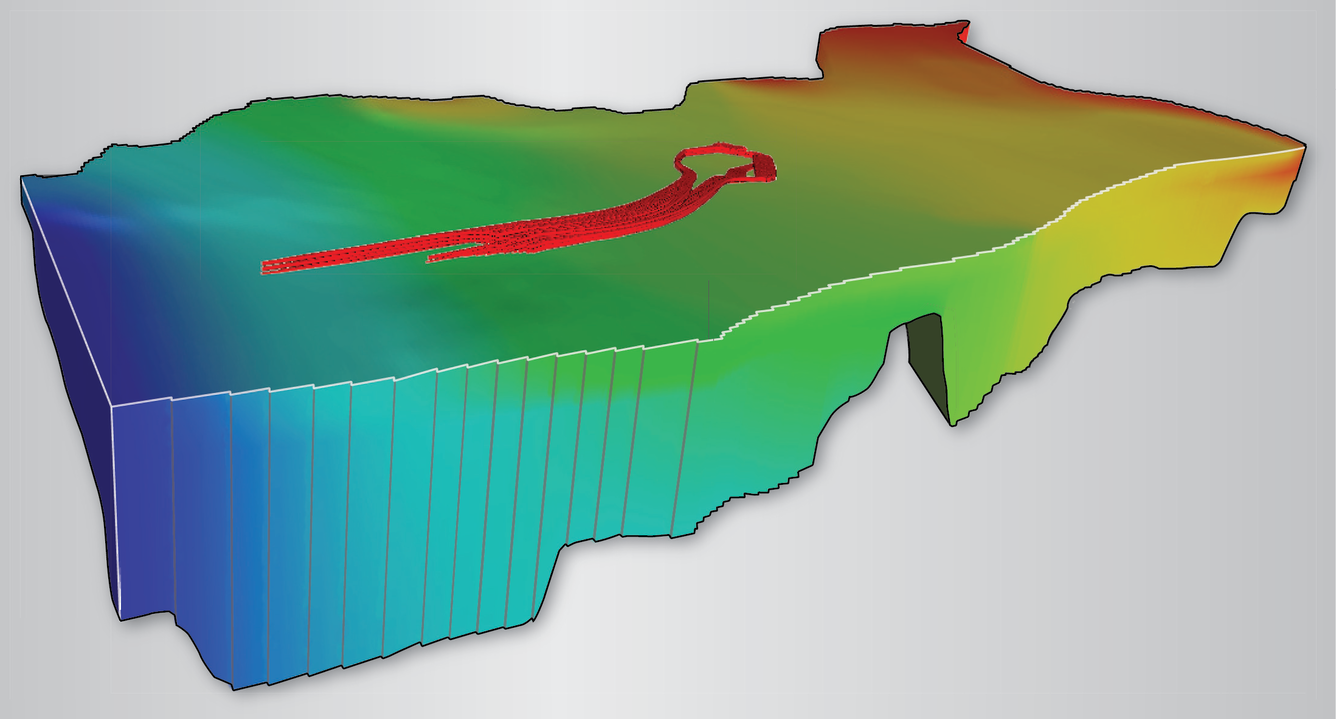
In 2012, we conducted a comprehensive comparison between the steady-state model's estimates of groundwater source areas and velocities and independently derived estimates. Our findings indicated that the model's accuracy is highest in regions characterized by large sediment beds within the aquifer's geology (Fisher and others, 2012).
Our dedicated scientists continuously gather new data on groundwater depth, flow patterns, and geological characteristics. Incorporating these datasets will enhance our model predictions, improving our ability to track contaminant movement and forecast groundwater availability.
Understanding Model Types
Steady-State Model: This model assumes that inflows into the aquifer equal outflows, indicating no time-dependent changes in aquifer storage. It presumes consistent flow direction and velocity over time.
Transient Model: In contrast, the transient model accommodates variability in water inflows and outflows in response to short-term and long-term changes related to climate or water use. This flexibility allows for alterations in aquifer storage, flow direction, and velocity.
By leveraging these sophisticated modeling techniques, we aim to better manage and protect the valuable groundwater resources of the eastern Snake River Plain.
Future Model Developments
In the coming years, the USGS plans to release a Scientific Investigations Report detailing a groundwater-flow model calibrated using a regularized inversion approach. Beginning in 2027, we will initiate the construction of a contaminant-transport model designed to simulate the dispersive effects of smaller-scale heterogeneities and anisotropies within the subregional-scale framework. This plume-scale model will significantly enhance our understanding of contaminant migration dynamics, including the direction and rate of movement, as well as the processes and factors influencing chemical transformations.
To ensure comprehensive data collection and model accuracy, flow-model simulations will be conducted at both the subregional and plume scales. These simulations will help identify data-deficient areas within the study region, guiding the strategic placement of new boreholes for further investigation.
We are committed to employing a highly reproducible methodology for constructing the groundwater-flow and contaminant-transport models. All datasets, source code, and processing instructions utilized in the model development and analysis will be made available through multiple R packages, promoting transparency and reproducibility in our research.
At the Idaho National Laboratory Project Office (INLPO), we employ advanced numerical models to enhance our understanding of groundwater flow and the transport of chemical and radiochemical constituents within the eastern Snake River Plain aquifer system.
These models are vital tools for scientists, allowing them to systematically organize their knowledge of groundwater systems. They also provide critical insights for water resource managers regarding future water demands and the movement of contaminants within the aquifer.
Latest Model Releases
In 2010, our team developed sophisticated three-dimensional (3D) models to represent both steady-state and transient flow in the aquifer. These models illustrate the impacts of natural and human-induced changes on groundwater storage, flow direction, and water movement velocity.
In 2012, we conducted a comprehensive comparison between the steady-state model's estimates of groundwater source areas and velocities and independently derived estimates. Our findings indicated that the model's accuracy is highest in regions characterized by large sediment beds within the aquifer's geology (Fisher and others, 2012).
Our dedicated scientists continuously gather new data on groundwater depth, flow patterns, and geological characteristics. Incorporating these datasets will enhance our model predictions, improving our ability to track contaminant movement and forecast groundwater availability.
Understanding Model Types
Steady-State Model: This model assumes that inflows into the aquifer equal outflows, indicating no time-dependent changes in aquifer storage. It presumes consistent flow direction and velocity over time.
Transient Model: In contrast, the transient model accommodates variability in water inflows and outflows in response to short-term and long-term changes related to climate or water use. This flexibility allows for alterations in aquifer storage, flow direction, and velocity.
By leveraging these sophisticated modeling techniques, we aim to better manage and protect the valuable groundwater resources of the eastern Snake River Plain.
Future Model Developments
In the coming years, the USGS plans to release a Scientific Investigations Report detailing a groundwater-flow model calibrated using a regularized inversion approach. Beginning in 2027, we will initiate the construction of a contaminant-transport model designed to simulate the dispersive effects of smaller-scale heterogeneities and anisotropies within the subregional-scale framework. This plume-scale model will significantly enhance our understanding of contaminant migration dynamics, including the direction and rate of movement, as well as the processes and factors influencing chemical transformations.
To ensure comprehensive data collection and model accuracy, flow-model simulations will be conducted at both the subregional and plume scales. These simulations will help identify data-deficient areas within the study region, guiding the strategic placement of new boreholes for further investigation.
We are committed to employing a highly reproducible methodology for constructing the groundwater-flow and contaminant-transport models. All datasets, source code, and processing instructions utilized in the model development and analysis will be made available through multiple R packages, promoting transparency and reproducibility in our research.