
Monitoring
Monitoring
Filter Total Items: 28

Groundwater Quality and Nutrient Trends near Marsing, Southwestern Idaho
In cooperation with the Idaho Department of Environmental Quality, we sampled groundwater from 15 wells during spring 2018 near the city of Marsing in rural northwestern Owyhee County, southwestern Idaho. Samples were analyzed for field parameters, nutrients, trace elements, major inorganics, and dissolved gas, including methane. To examine trends in individual wells and in the region, ammonia and...
INLPO Water Monitoring
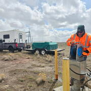
The U.S. Geological Survey (USGS) first characterized the water resources of the Idaho National Laboratory (INL) area prior to the establishment of nuclear reactor testing facilities in 1949. Since then, the USGS has maintained monitoring networks for groundwater quality and water levels at the INL. These efforts provide essential data on hydrologic trends and track the movement of radioactive and...
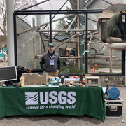
INLPO Outreach
The USGS Idaho National Laboratory Project Office is committed to engaging the public through a variety of outreach initiatives across multiple locations. We provide enriching educational materials and content tailored for diverse audiences, including K-12 students, college classes, public forums, Water Festivals, Earth Day events, and citizen advisory board meetings. Our goal is to foster a...
Idaho National Laboratory Project Office (INLPO)
The mission of the U.S. Geological Survey (USGS) at the Idaho National Laboratory Project Office (INLPO) is to implement a comprehensive groundwater monitoring and hydrogeologic studies program. This program focuses on evaluating the availability and movement of water within the eastern Snake River Plain (ESRP) aquifer, in alignment with the Department of Energy's (DOE) strategic goal of...

Selenium in the Blackfoot River Watershed
The upper Blackfoot River receives runoff from 12 large phosphate mines. Shale waste rock that is a byproduct of mining is highly enriched in naturally occurring selenium. At optimal concentrations, selenium can be a positive nutrient and antioxidant in mammals and fish. At elevated concentrations, however, it can damage fish and animal immune systems. As early as 1996, livestock deaths attributed...

Streamflow Evaluation for Wild and Scenic Rivers, Owyhee Canyonlands Wilderness
Several river segments in the Owyhee Canyonlands Wilderness have been designated as “Wild and Scenic” under the Omnibus Public Lands Management Act of 2009. This designation is intended to protect the “outstanding remarkable values” (ORVs) in this area—specifically fish and wildlife habitat, scenic and geological features, and recreational opportunities. The Bureau of Land Management (BLM) is...

Occurrence and Potential Risk of Microplastics in Lake Mead and the Delaware River
There is mounting evidence that microplastics present a significant threat to aquatic organisms. Microplastics – defined as plastic particles less than 5 mm in diameter – come from many different sources, including synthetic textiles, industrial waste products, personal care products, and the breakdown of litter, car tires, and other objects. This study will assess the occurrence of microplastics...

Coeur d'Alene Basin Water-Quality Monitoring
We partner with the EPA to conduct long-term water-quality and streamflow monitoring in the Coeur d’Alene River Basin, which has been widely impacted by historic mining activities.

Estimating Seepage Rates of Streams, Ponds, and Lakes at the Camas National Wildlife Refuge
The Camas National Wildlife Refuge provides essential resting, feeding, and nesting habitat for waterfowl including migratory birds. A variety of other animals, large and small, are found there, too. Since the refuge was established in 1937, the U.S. Fish and Wildlife Service (USFWS) has been responsible for managing this vital resource. Traditionally, Camas Creek and groundwater inflow have fed...

Wood River Valley Hydrologic Trends and Comparisons
Wood River Valley residents rely on groundwater for domestic supply, either from domestic or municipal-supply wells. The rapid population growth since the 1970s has caused concern about the long-term sustainability of the groundwater resource.

Surrogate Technologies for Estimating Suspended Sediment in the Snake and Clearwater Rivers
Because fluvial sediment poses both economic and ecological problems, resource managers need a safe, cost-effective way to measure sediment in streams, particularly in remote areas.

Sediment Sampling in the Snake and Clearwater River Basins
Are there ways to manage sediment before it accumulates in Lower Granite Reservoir? If so, resource managers must know exactly how much sediment is being transported in the lower Snake and Clearwater River basins, the grain-size distribution of the sediment that is being transported, which subbasins are contributing the most sediment, and how the sediment is being deposited once it is delivered to...