
Delta-Mendota Canal: Evaluation of Groundwater Conditions and Land Subsidence
In areas adjacent to the Delta-Mendota Canal (DMC), extensive groundwater withdrawal from the San Joaquin Valley aquifer system has caused areas of the ground to sink as much as 10 feet, a process known as land subsidence. This could result in serious operational and structural issues for the Delta-Mendota Canal (DMC). In response, the USGS is studying and providing information on groundwater conditions and land subsidence in the San Joaquin Valley.
Regional Setting and Historical Context
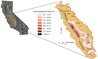
Groundwater pumping caused widespread compaction and resultant land subsidence between 1926 and 1970, locally exceeding 26 feet. Surface-water imports in the early 1970s resulted in decreased pumping, reduced compaction rate, and a steady recovery of groundwater levels. However, lack of imported surface-water availability during 1976-77, 1986-92, and 2007-09 caused groundwater-pumping increases, renewed compaction, and declines in water-levels to near-historic lows. The resulting land subsidence has reduced the freeboard and flow capacity of the Delta-Mendota Canal, the California Aqueduct, and other canals that transport floodwater and deliver irrigation water , requiring expensive repairs.
One area of the Central Valley, southwest of Mendota, has experienced some of the highest levels of subsidence in California. From 1925 to 1977, this area suffered over 29 feet of subsidence.
The Delta-Mendota Canal
The canal begins at the C.W. Bill Jones Pumping Plant, which pumps water 197 feet from the Sacramento-San Joaquin Delta. The canal runs south along the western edge of the San Joaquin Valley, parallel to the California Aqueduct for most of its journey, but it diverges to the east after passing San Luis Reservoir, which receives some of its water. The water is pumped from the canal and into O'Neill Forebay. Then it is pumped into San Luis Reservoir by the Gianelli Pumping-Generating Plant. Occasionally, water from O'Neill Forebay is released into the canal. The Delta-Mendota Canal ends at Mendota Pool, on the San Joaquin River near the town of Mendota, 30 miles west of Fresno.
Study Objectives
- improve the understanding of groundwater conditions and land subsidence and how groundwater resources have changed over time
- determine the location, extent, and magnitude of changes in land-surface elevation along the DMC for 2003-10 using persistent scatterer Interferometric Synthetic Aperture Radar (InSAR) methods
- develop and implement an approach to use persistent scatterer InSAR to monitor subsidence along the DMC
- develop groundwater flow and land-subsidence simulations to provide stakeholders with information to help manage and limit future land subsidence along the DMC
Evaluation of Land Subsidence along the Delta-Mendota Canal
The U.S. Geological Survey, in cooperation with the U.S. Bureau of Reclamation and the San Luis and Delta-Mendota Water Authority, assessed land subsidence in the vicinity of the Delta-Mendota Canal as part of an effort to minimize future subsidence-related damages to the canal. The location, magnitude, and stress regime of land-surface deformation during 2003-10 were determined by using extensometer, Global Positioning System (GPS), Interferometric Synthetic Aperture Radar (InSAR), spirit leveling, and groundwater-level data. Comparison of continuous GPS, shallow extensometer, and groundwater-level data, combined with results from a one-dimensional model, indicated the vast majority of the compaction took place beneath the Corcoran Clay, the primary subsurface regional confining unit.
Below are other science projects associated with this project.

Delta-Mendota Canal: Using Groundwater Modeling to Analyze Land Subsidence
In areas adjacent to the Delta-Mendota Canal (DMC), extensive groundwater withdrawal from the San Joaquin Valley aquifer system has caused areas of the ground to sink as much as 10 feet, a process known as land subsidence. This could result in serious operational and structural issues for the Delta-Mendota Canal (DMC). In response, the USGS is studying and providing information on groundwater conditions and land subsidence in the San Joaquin Valley.
Regional Setting and Historical Context
Groundwater pumping caused widespread compaction and resultant land subsidence between 1926 and 1970, locally exceeding 26 feet. Surface-water imports in the early 1970s resulted in decreased pumping, reduced compaction rate, and a steady recovery of groundwater levels. However, lack of imported surface-water availability during 1976-77, 1986-92, and 2007-09 caused groundwater-pumping increases, renewed compaction, and declines in water-levels to near-historic lows. The resulting land subsidence has reduced the freeboard and flow capacity of the Delta-Mendota Canal, the California Aqueduct, and other canals that transport floodwater and deliver irrigation water , requiring expensive repairs.
One area of the Central Valley, southwest of Mendota, has experienced some of the highest levels of subsidence in California. From 1925 to 1977, this area suffered over 29 feet of subsidence.
The Delta-Mendota Canal
The canal begins at the C.W. Bill Jones Pumping Plant, which pumps water 197 feet from the Sacramento-San Joaquin Delta. The canal runs south along the western edge of the San Joaquin Valley, parallel to the California Aqueduct for most of its journey, but it diverges to the east after passing San Luis Reservoir, which receives some of its water. The water is pumped from the canal and into O'Neill Forebay. Then it is pumped into San Luis Reservoir by the Gianelli Pumping-Generating Plant. Occasionally, water from O'Neill Forebay is released into the canal. The Delta-Mendota Canal ends at Mendota Pool, on the San Joaquin River near the town of Mendota, 30 miles west of Fresno.
Study Objectives
- improve the understanding of groundwater conditions and land subsidence and how groundwater resources have changed over time
- determine the location, extent, and magnitude of changes in land-surface elevation along the DMC for 2003-10 using persistent scatterer Interferometric Synthetic Aperture Radar (InSAR) methods
- develop and implement an approach to use persistent scatterer InSAR to monitor subsidence along the DMC
- develop groundwater flow and land-subsidence simulations to provide stakeholders with information to help manage and limit future land subsidence along the DMC
Evaluation of Land Subsidence along the Delta-Mendota Canal
The U.S. Geological Survey, in cooperation with the U.S. Bureau of Reclamation and the San Luis and Delta-Mendota Water Authority, assessed land subsidence in the vicinity of the Delta-Mendota Canal as part of an effort to minimize future subsidence-related damages to the canal. The location, magnitude, and stress regime of land-surface deformation during 2003-10 were determined by using extensometer, Global Positioning System (GPS), Interferometric Synthetic Aperture Radar (InSAR), spirit leveling, and groundwater-level data. Comparison of continuous GPS, shallow extensometer, and groundwater-level data, combined with results from a one-dimensional model, indicated the vast majority of the compaction took place beneath the Corcoran Clay, the primary subsurface regional confining unit.
Below are other science projects associated with this project.