
Surface Water
Surface Water
Filter Total Items: 59

Watershed Boundary Dataset for Mississippi - Hydrologic Unit Codes (HUC)
The U.S. Geological Survey, in cooperation with the Mississippi Department of Environmental Quality, U.S. Department of Agriculture-Natural Resources Conservation Service, Mississippi Department of Transportation, U.S. Department of Agriculture-Forest Service, and the Mississippi Automated Resource INformation System developed a 1:24,000-scale Watershed Boundary Dataset for Mississippi including...

Hattiesburg Flood Inundation
Floods are the most common and widespread of all natural disasters in the United States and are the leading cause of weather related deaths. Advances in technology have improved warning systems and have helped to decrease the loss of life over the past 50 years. Several sources of information are available to citizens and public officials to help make timely decisions regarding flood awareness and...

Hardened Gages—Built to Survive
1 June 2010 Hurricane season starts today, and the USGS Lower Mississippi-Gulf Water Science Center is committed to collecting and providing the most up-to-date information before, during, and after the storms that are sure to come our way. When a hurricane or tropical storm is approaching, accurate and timely storm data are crucial in making good decisions regarding personal safety and property...

USGS Hurricane-related Publications for Louisiana
USGS Information and Links Hurricane Hazards—A National Threat (fact sheet) USGS Natural Hazards - Hurricanes Hurricane Forecast Information National Hurricane Center—(NWS) Current Tropical Forecast Information GOES-8 Atlantic Infrared Imagery GOES-8 Atlantic Visible Imagery Earth Scan Laboratory—(LSU) GOES-8 Atlantic Infrared Imagery GOES-8 Atlantic Visible Imagery GOES-8 Atlantic Color Infrared...

USGS Louisiana Coastal Sites
USGS Louisiana Coastal Sites Hurricane season starts today, and the USGS Lower Mississippi-Gulf Water Science Center is committed to collecting and providing the most up-to-date information before, during, and after the storms that are sure to come our way. When a hurricane or tropical storm is approaching, accurate and timely storm data is crucial in making good decisions regarding personal...

Forecast Information and Imagery
River and Coastal Forecasts The USGS is not a forecasting agency, but the National Weather Service (NWS) is, and they make extensive use of the data we collect in their effort to provide you with the most accurate and up-to-date forecasts of many Louisiana rivers and streams, and weather along the coast. The links below will provide you with direct access to the NWS forecasts for different areas...

Turbidity Monitoring in Tennessee
A study involving suspended-sediment and turbidity monitoring at streamgaging stations near the segment of State Route 840 under construction between Fairview and Bending Chestnut.

Tennessee River (TENN) Basin Study
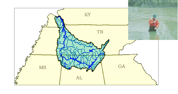
The Tennessee (TENN) River Basin encompasses an area of 40,890 square miles, making it the largest tributary to the Ohio River. The Tennessee River flows through portions of seven states: Virginia, North Carolina, Tennessee, Alabama, Georgia, Mississippi, and Kentucky.

Regional Hydraulic Geometry Characteristics of the Boston Mountains in Arkansas
LMG-WSC hydrologist, in collaboration with Arkansas Natural Resource Commission scientist are analyzing stream channel geomorphic characteristics at 15 gaged stable stream sites in the Boston Mountains of Arkansas. Field data collection entails topographic surveys of selected stream reaches and analysis of bed and bar sediments. Topographic surveys, running from hundreds to thousands of feet, are...

Water Use Trends in Alabama
Since 1950 when the U.S. Geological Survey (USGS) first conducted water-use compilations, important changes in water use have occurred in Alabama. The early part of the history (1950 to 1980) showed a steady increase in water use. During this time, the expectation was that, as the population increased, so would water use. Contrary to this expectation, reported water withdrawals declined in 1985...
Lower Tennessee River (LTEN) Basin Study
Welcome....the Lower Tennessee River Basin in Tennessee, Alabama, Georgia, Kentucky, and Mississippi is one of the 59 study units that are part of the U.S. Geological Survey's National Water-Quality Assessment (NAWQA) Program.The long-term goals of this program are to describe the status and trends in the quality of a large, representative part of the Nation's surface- and ground-water resources...

Metro Nashville Flood Monitoring Project
Metro Nashville Flood Monitoring Project-This project monitors the Cumberland River and it's tributaries around the Nashville Metro Area.