
Spring 2026 Newsletter - In The Flow
In this Spring 2026 edition: River measurements from the air • New drought forecasting tool • Updates to our water monitoring network • New publications
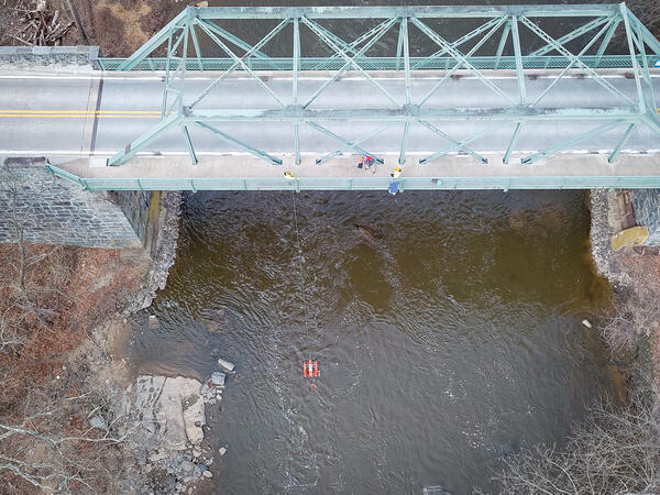
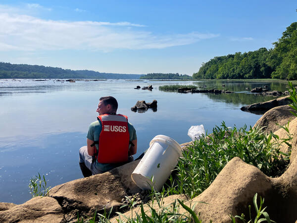
Measuring Rivers From The Air
The USGS is testing how to measure streamflow from above using small drones.
Measuring streamflow from drones will give the USGS another tool to monitor rivers and streams. It would be particularly useful in flooding situations where it is unsafe for hydrologic technicians to survey.
If this project is successful, it will enable technicians to measure flooding rivers and streams at a safe distance, giving us a chance to capture crucial data.
How does it work?
USGS scientists are using high-definition cameras attached to drones and custom USGS software that calculates stream velocity from video.
At this stage in the project, we are testing the system against in-stream velocity measurements using the standard stream velocity instrument, the ADCP (acoustic doppler current profiler), as seen in the above photo along this scenic stretch of the Brandywine Creek in Delaware.
Our ability to measure streamflow with this method is still in its early stages, and this project is part of the Next Generation Water Observing System (NGWOS), a program which develops innovative ways to improve water science and keep communities informed during extreme events.
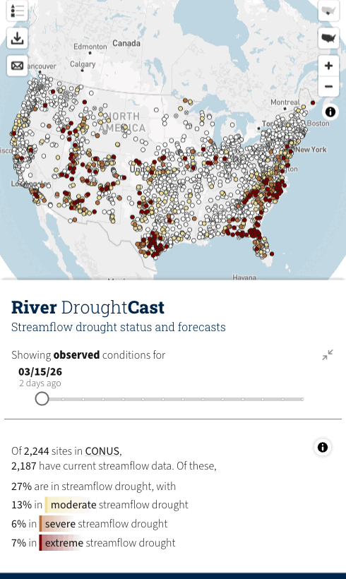
New AI Tool Forecasts Drought 90 Days Ahead Nationwide
The food we eat, the water we drink, the clothes we buy, and the electricity we use depend on sufficient amounts of clean, accessible water.
When water flowing through rivers and streams drops to unusually low levels - termed “streamflow drought” - water managers may need to determine ways to allocate sufficient water to meet home, farm, business, and energy needs.
To evaluate streamflow drought conditions, USGS developed Artificial Intelligence/Machine Learning (AI/ML) models that forecast streamflow drought up to 13 weeks (3 months) into the future.
The USGS River DroughtCast uses machine learning models trained on data from thousands of USGS streamgages, some with more than 100 years of continuous records, to forecast when rivers and streams will drop to abnormally low levels.
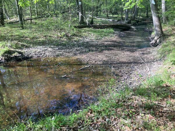
A stream with low flow. Zekiah Swamp Run Near Newtown, MD (USGS-01660920). Photo credit Brett McFarland/USGS.
Streamflow drought forecasts help decision makers anticipate periods of limited water availability so they can help develop plans for ensuring the safety and health of their communities.
“The USGS is putting more than a century of streamflow data to work in a completely new way, using machine learning to predict streamflow drought weeks in advance,” said John Hammond, USGS project manager for the drought forecasting system.
Streamflow drought occurs when rivers and streams stay below normal levels for extended periods, distinct from the more familiar meteorological droughts characterized by lack of rainfall. While lack of rain typically comes first, factors like soil moisture, snowpack, and groundwater all influence how dry conditions translate into reduced river flows. This makes streamflow drought particularly difficult to predict but critically important for water resource planning.
A user of the tool can choose any length of forecast between one and 13 weeks, with the tool being most reliable in the first four to six weeks. Regardless of the length of the forecast, the first week of severe or extreme drought conditions are correctly predicted approximately 75% of the time. This reliability drops to approximately 55% of the time by week 13. All forecasts include confidence estimates so users can understand the reliability of predictions during different timeframes.
River DroughtCast assists with a gap between short-term weather forecasts and seasonal water supply outlooks. Farmers relying on surface water irrigation may adjust planting schedules and crop selections. Municipal water managers may implement conservation measures. Recreation operators may prepare for impacts to fishing, boating and other water-dependent activities.
River DroughtCast currently provides forecasts for more than 3,000 USGS streamgage locations with at least 40 years of data. Developers are working on the next version to expand public access to areas without gages and to further improve forecast accuracy.
The USGS created River DroughtCast in partnership with NOAA’s National Integrated Drought Information System, which supported the project throughout its development. ∎
🔗 River DroughtCast || Learn More || FAQ
This article was compiled from two articles, here and here.
Moores Run Streamgage in Baltimore Makes Its Return, and Other Water Monitoring Updates
We recently restarted monitoring gage height at Moores Run at Radecke Ave at Baltimore, MD (USGS- 01585230). Moores Run is the 5th flashiest watershed monitored by the USGS in the country, so we record data every minute, which is more frequent than usual but is needed because of how quickly water crests and recedes. The site is now also equipped with a HIVIS camera that takes photos every 5 minutes.
Further additions to our water monitoring network:
- Little Deer Creek Reservoir near Shawsville, MD (USGS-01579920): Gage height, precipitation, water level, and camera.
- Fishing Creek at Mountaindale, MD (USGS-01641501): Gage height.
- We added a HIVIS stream camera to Northwest Branch Anacostia River at Brentwood (USGS-01651003).
We are no longer monitoring at Rock Creek at Sherrill Drive Washington, DC (USGS-01648000). Current conditions for Rock Creek can still be found at the Joyce Road location (USGS-01648010) just a mile downstream, where we monitor water levels, discharge, and water-quality.
We also discontinued the following monitoring locations:
- Dundee Creek Tributary at Chase, MD (USGS-01585149)
- Unnamed Ditch on Wilson Pt Rd at Middle River, MD (USGS-01585175)
- Lower Patuxent River Tributary Above Wilde Lake at Columbia, MD (USGS-01593370)
- Lower Patuxent River Tributary above Lake Elkhorn near Guilford, MD (USGS-01593450)
- Luzon Branch above Rock Creek at Washington DC (USGS-01648011)
- Piscataway Creek Tributary at Joint Base Andrews, MD (USGS-01653522)
- Piscataway Creek at Woodyard, MD (USGS-01653560)
- Meetinghouse Branch at Camp Springs, MD (USGS-01653620)
- Unnamed Impoundment nr St Jones River nr Dover, DE (USGS-390808075295102)
If you have any questions or want to start a conversation about water monitoring at a location, please contact Chuck Walker (cwwalker@usgs.gov).
Publication Publicity
Data Releases