
Our Geomorphology Team works across all spatial scales to optimize monitoring, modeling, and interpretative work tailored to the needs of our cooperators. We have extensive experience in leveraging large geospatial datasets and advanced GIS analyses to meet these needs, and our methods include hydraulic flow modeling, sediment source tracking, watershed-wide GIS-based morphological analyses, digital elevation model differencing techniques, advanced lidar analyses, sediment source tracking, and morphological surveys.
In the field we deploy cutting-edge surveying equipment and techniques to guarantee our morphological surveys meet the rigor expected of the U.S. Geological Survey, and our team’s varied backgrounds allow for the application and interpretation of innovative field assessments across disciplines. Our lab is renowned for sediment source tracking, with decades of expertise developing sediment budgets and sediment source fingerprinting. We often collaborate with the Center’s Fate and Bioremediation Team to track sediment-bound contaminants of concern to their probable source.
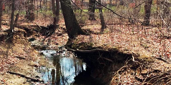
Streambank material dominates in watershed

This study examines the contributions of sediment sources within Upper Difficult Run, a suburbanized watershed in Fairfax County, Virginia. A sediment source library was constructed from stream banks, forest soils, and road dust.
Pavement contributing sediment to urban streams
Dirt, sand, and other particulate material on parking lots and streets is washing off into urban streams, reports a new study by the U.S. Geological Survey Regional Stream Quality Assessment.
Sediment Sources in Linganore Creek Watershed

Sediment fingerprinting quantifies the delivery of finegrained sediment from a watershed and sediment-budget measurements quantify the erosion and deposition of fine-grained sediment. Both approaches were used to determine the sources of sediments.
Lab Capabilities
- Dry- and wet-sieving of sediments to a variety of particle sizes, 63 microns to 2000 microns (2mm)
- Laser diffraction particle size analysis between <2 microns to 5000 microns
- Dry sieve-based particle size distribution
- Connections with existing labs for Fallout Radionuclide (FRN) analysis, organic carbon and elemental metals analyses, stable isotope analysis, as well as optically stimulated luminescence and C-14 radiocarbon dating
- XRF-based elemental composition analysis (in production)
- Loss-on-ignition organic carbon analysis
- Bulk density sampling and analysis
- Terrestrial and riverine sediment sampling, including street sediment sweeps & vacuuming, passive sampling with Walling Tubes, ISCO sampling, and high-volume sediment sampling
This video highlights the Geomorphology team at the MD-DE-DC Water Science Center.

USGS Capabilities: Geomorphology
This video highlights the Geomorphology team at the MD-DE-DC Water Science Center, and features interviews with several USGS scientists. They discuss what skills they possess, what technologies they use, and how their research helps advance the mission of the USGS. In addition to interviews, the video also features video collected from various field site visits and lab-work.
Our Geomorphology Team works across all spatial scales to optimize monitoring, modeling, and interpretative work tailored to the needs of our cooperators. We have extensive experience in leveraging large geospatial datasets and advanced GIS analyses to meet these needs, and our methods include hydraulic flow modeling, sediment source tracking, watershed-wide GIS-based morphological analyses, digital elevation model differencing techniques, advanced lidar analyses, sediment source tracking, and morphological surveys.
In the field we deploy cutting-edge surveying equipment and techniques to guarantee our morphological surveys meet the rigor expected of the U.S. Geological Survey, and our team’s varied backgrounds allow for the application and interpretation of innovative field assessments across disciplines. Our lab is renowned for sediment source tracking, with decades of expertise developing sediment budgets and sediment source fingerprinting. We often collaborate with the Center’s Fate and Bioremediation Team to track sediment-bound contaminants of concern to their probable source.
Streambank material dominates in watershed
This study examines the contributions of sediment sources within Upper Difficult Run, a suburbanized watershed in Fairfax County, Virginia. A sediment source library was constructed from stream banks, forest soils, and road dust.
Pavement contributing sediment to urban streams
Dirt, sand, and other particulate material on parking lots and streets is washing off into urban streams, reports a new study by the U.S. Geological Survey Regional Stream Quality Assessment.
Sediment Sources in Linganore Creek Watershed
Sediment fingerprinting quantifies the delivery of finegrained sediment from a watershed and sediment-budget measurements quantify the erosion and deposition of fine-grained sediment. Both approaches were used to determine the sources of sediments.
Lab Capabilities
- Dry- and wet-sieving of sediments to a variety of particle sizes, 63 microns to 2000 microns (2mm)
- Laser diffraction particle size analysis between <2 microns to 5000 microns
- Dry sieve-based particle size distribution
- Connections with existing labs for Fallout Radionuclide (FRN) analysis, organic carbon and elemental metals analyses, stable isotope analysis, as well as optically stimulated luminescence and C-14 radiocarbon dating
- XRF-based elemental composition analysis (in production)
- Loss-on-ignition organic carbon analysis
- Bulk density sampling and analysis
- Terrestrial and riverine sediment sampling, including street sediment sweeps & vacuuming, passive sampling with Walling Tubes, ISCO sampling, and high-volume sediment sampling
This video highlights the Geomorphology team at the MD-DE-DC Water Science Center.
USGS Capabilities: Geomorphology
This video highlights the Geomorphology team at the MD-DE-DC Water Science Center, and features interviews with several USGS scientists. They discuss what skills they possess, what technologies they use, and how their research helps advance the mission of the USGS. In addition to interviews, the video also features video collected from various field site visits and lab-work.