
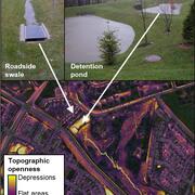
This video acts as a “visual abstract” for a recent publication analyzing the stormwater management practices in Clarksburg, MD. The video features interviews with the team of USGS scientists as well as a water specialist from Montgomery County.
Marina Metes
Marina Metes is a Physical Scientist and has been with the U.S. Geological Survey since 2015, currently working at the MD-DE-DC Water Science Center in the Baltimore office.
Marina’s research applies remote sensing and geospatial analysis techniques to answer questions related to hydrology and fluvial geomorphology. She develops analytical tools and datasets to characterize streams and landscapes and evaluate changes over time.
Science and Products
Remotely mapping stormwater facility footprints and storage volumes
Stormwater management practices are being used throughout the Chesapeake Bay watershed to reduce flood risks and pollutant loads, but consistent and comprehensive maps of these practices are often lacking. Stormwater managers often have incomplete information about the location and storage volume of stormwater facilities within their jurisdiction. Therefore, the USGS is working to develop...

Using Multiple Indicators to Assess Stream Condition in the Chesapeake Bay
USGS is working with federal, state and local partners to develop multiple assessments of stream and river conditions in non-tidal areas of the Chesapeake Bay watershed. These assessments will help managers preserve stream health and improve biological conditions in impaired streams as the human population and climate continue to change in this region.

New study highlights impact of current and historic land use on stream incision in Maryland Piedmont headwaters
A new method was developed to remotely identify small, eroding streams and measure change over time.

Understanding the Effects of Stormwater Management Practices on Water Quality and Flow
Urban development can have detrimental impacts on streams including altering hydrology, increasing nutrient, sediment, and pollutant loadings, and degrading biological integrity. Stormwater Best Management Practices (BMPs) can be used to mitigate the effects of urban development by retaining large volumes of stormwater runoff and treating runoff to remove pollutants. This project focuses on...

USGS Chesapeake Publication Receives National Award for Outstanding Technology Paper
The paper, Ephemeral Stream Network Extraction from Lidar-Derived Elevation and Topographic Attributes in Urban and Forested Landscapes, describes a new method of remotely mapping ephemeral headwater streams using wetness index and topographic openness derived from lidar. This work is part of a long-term USGS study assessing the impacts of suburban development on a range of ecosystem functions...

Leveraging Existing USGS Streamgage Data to Map Flood-Prone Areas
We will develop reproducible workflows in R and Python to combine already existing and underutilized field data collected as part of the USGS streamgage network with remotely sensed data to map flood-prone areas for various recurrence intervals in both gaged and ungaged stream reaches.

Tracking Status and Trends in Seven Key Indicators of River and Stream Condition in the Chesapeake Bay Watershed
Identifying and tracking the status of, and trends in, stream health within the Chesapeake Bay watershed is essential to understanding the past, present, and future trajectory of the watershed’s resources and ecological condition. A team of USGS scientists is meeting this need with an initiative to track the status of, and trends in, key indicators of the health of non-tidal freshwater streams...
Geomorphology and Sediment Team
Our Geomorphology Team works across all spatial scales to optimize monitoring, modeling, and interpretative work tailored to the needs of our cooperators. We have extensive experience in leveraging large geospatial datasets and advanced GIS analyses to meet these needs, and our methods include hydraulic flow modeling, sediment source tracking, watershed-wide GIS-based morphological analyses...

Quantifying Floodplain Ecological Processes and Ecosystem Services in the Delaware River Watershed
Floodplain and wetland areas provide critical ecosystem services to local and downstream communities by retaining sediments, nutrients, and floodwaters. The loss of floodplain functionality due to land use conversion and degradation reduces the provisioning of these services. Assessing, quantifying, and valuing floodplain ecosystem services provide a framework to estimate how floodplain systems...

Soaking Up Stormwater
This video acts as a “visual abstract” for a recent publication analyzing the stormwater management practices in Clarksburg, MD. The video features interviews with the team of USGS scientists as well as a water specialist from Montgomery County.
Soaking Up Stormwater (AD)
This video acts as a “visual abstract” for a recent publication analyzing the stormwater management practices in Clarksburg, MD. The video features interviews with the team of USGS scientists as well as a water specialist from Montgomery County.
This video acts as a “visual abstract” for a recent publication analyzing the stormwater management practices in Clarksburg, MD. The video features interviews with the team of USGS scientists as well as a water specialist from Montgomery County.
Science and Products
Remotely mapping stormwater facility footprints and storage volumes
Stormwater management practices are being used throughout the Chesapeake Bay watershed to reduce flood risks and pollutant loads, but consistent and comprehensive maps of these practices are often lacking. Stormwater managers often have incomplete information about the location and storage volume of stormwater facilities within their jurisdiction. Therefore, the USGS is working to develop...
Using Multiple Indicators to Assess Stream Condition in the Chesapeake Bay
USGS is working with federal, state and local partners to develop multiple assessments of stream and river conditions in non-tidal areas of the Chesapeake Bay watershed. These assessments will help managers preserve stream health and improve biological conditions in impaired streams as the human population and climate continue to change in this region.
New study highlights impact of current and historic land use on stream incision in Maryland Piedmont headwaters
A new method was developed to remotely identify small, eroding streams and measure change over time.
Understanding the Effects of Stormwater Management Practices on Water Quality and Flow
Urban development can have detrimental impacts on streams including altering hydrology, increasing nutrient, sediment, and pollutant loadings, and degrading biological integrity. Stormwater Best Management Practices (BMPs) can be used to mitigate the effects of urban development by retaining large volumes of stormwater runoff and treating runoff to remove pollutants. This project focuses on...
USGS Chesapeake Publication Receives National Award for Outstanding Technology Paper
The paper, Ephemeral Stream Network Extraction from Lidar-Derived Elevation and Topographic Attributes in Urban and Forested Landscapes, describes a new method of remotely mapping ephemeral headwater streams using wetness index and topographic openness derived from lidar. This work is part of a long-term USGS study assessing the impacts of suburban development on a range of ecosystem functions...
Leveraging Existing USGS Streamgage Data to Map Flood-Prone Areas
We will develop reproducible workflows in R and Python to combine already existing and underutilized field data collected as part of the USGS streamgage network with remotely sensed data to map flood-prone areas for various recurrence intervals in both gaged and ungaged stream reaches.
Tracking Status and Trends in Seven Key Indicators of River and Stream Condition in the Chesapeake Bay Watershed
Identifying and tracking the status of, and trends in, stream health within the Chesapeake Bay watershed is essential to understanding the past, present, and future trajectory of the watershed’s resources and ecological condition. A team of USGS scientists is meeting this need with an initiative to track the status of, and trends in, key indicators of the health of non-tidal freshwater streams...
Geomorphology and Sediment Team
Our Geomorphology Team works across all spatial scales to optimize monitoring, modeling, and interpretative work tailored to the needs of our cooperators. We have extensive experience in leveraging large geospatial datasets and advanced GIS analyses to meet these needs, and our methods include hydraulic flow modeling, sediment source tracking, watershed-wide GIS-based morphological analyses...
Quantifying Floodplain Ecological Processes and Ecosystem Services in the Delaware River Watershed
Floodplain and wetland areas provide critical ecosystem services to local and downstream communities by retaining sediments, nutrients, and floodwaters. The loss of floodplain functionality due to land use conversion and degradation reduces the provisioning of these services. Assessing, quantifying, and valuing floodplain ecosystem services provide a framework to estimate how floodplain systems...
Soaking Up Stormwater
This video acts as a “visual abstract” for a recent publication analyzing the stormwater management practices in Clarksburg, MD. The video features interviews with the team of USGS scientists as well as a water specialist from Montgomery County.
This video acts as a “visual abstract” for a recent publication analyzing the stormwater management practices in Clarksburg, MD. The video features interviews with the team of USGS scientists as well as a water specialist from Montgomery County.
Soaking Up Stormwater (AD)
This video acts as a “visual abstract” for a recent publication analyzing the stormwater management practices in Clarksburg, MD. The video features interviews with the team of USGS scientists as well as a water specialist from Montgomery County.
This video acts as a “visual abstract” for a recent publication analyzing the stormwater management practices in Clarksburg, MD. The video features interviews with the team of USGS scientists as well as a water specialist from Montgomery County.