
USGS Investigates Groundwater Drought Metrics Across the United States
In a pioneering study led by the U.S. Geological Survey (USGS), researchers analyzed groundwater levels across the conterminous United States to see how certain drought metrics, like severity and duration, change over time.
The study, published in the Journal of Hydrology, also helps to identify gaps in groundwater monitoring efforts so scientists can better characterize drought in the future. Understanding changes in groundwater levels over time is important because groundwater is a primary water source for approximately 144 million citizens in the United States, and groundwater discharge into rivers, lakes, and wetlands supports ecosystems and the survival of many endangered species.
“Determining how groundwater-based drought characteristics differ by region and over time is needed to assess the impacts of drought and to support drought management actions,” said USGS lead author and research hydrologist Glenn Hodgkins.
Groundwater Data Analysis
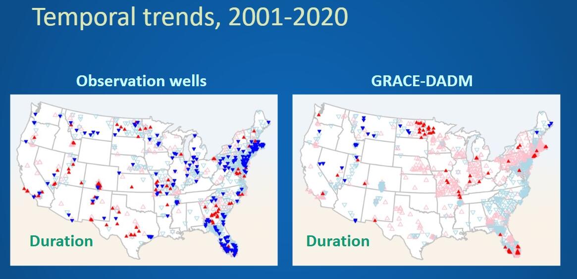
Researchers examined drought-related changes in groundwater levels throughout the United States using data collected from thousands of wells. They also used data that were remotely-sensed by satellite, the Gravity Recovery and Climate Experiment (GRACE) mission, which measures large-area changes in total water storage on and below the ground surface. This data is then used in the Drought Monitor Data Assimilation (DADM), which models weekly groundwater levels to a resolution of approximately 7.5 by 7.5 miles.
Average groundwater-drought conditions across the U.S. indicate that there tends to be longer and more severe droughts in drier areas like the Southwest than in wetter areas like the Northeast. However, groundwater drought has changed in recent decades in some regions. Based on well data from 1981 to 2020, the severity and length of groundwater drought was seen to decrease at many locations in the Northeast, while parts of the Southeast saw many increases.
Additionally, scientists observed large differences in groundwater-drought trends from 2001 to 2020 in some U.S. regions, when comparing data collected at wells to data from GRACE-DADM. This may be due to the resolution of the GRACE-DADM data and the fact that it represents shallow groundwater while groundwater levels measured in wells can be deep below the land surface. This finding is important because remote-sensing methods are potentially valuable for filling in the limited spatial coverage of well monitoring in many areas but currently have some limitations.
Looking to the Future of Groundwater Monitoring
The study findings indicate that data from GRACE can support, but not replace, well monitoring. More continuous, long-term groundwater-monitoring wells are needed to represent drought trends in areas of the country with sparse or unavailable groundwater data, particularly in the western United States. This would provide a more complete picture of groundwater drought.