
Herring River Water-Quality Data
Exploring the available data collected by USGS and Cape Cod National Seashore in support of the Herring River restoration project
This storytelling explores the availability of water-quality data collected by the Cape Cod National Seashore and U.S. Geological Survey in support of the Herring River restoration project. It highlights the development of the monitoring program since the 1980s and the publication of Cape Cod National Seashore data in a U.S. Geological Survey data release.
The U.S. Geological Survey (USGS) New England Water Science Center installed, operated, and maintained surface water-quality sites at the Chequessett Neck Road dike on the Herring River from November 2015 through September 2018.
The goals of the data collection program were to establish a pre-restoration baseline water quality-dataset and to characterize concentrations of nutrients and other water-quality indicators in the estuary.
These data provide critical information and feedback needed as part of the adaptive management process being taken to guide management decisions and measure progress toward restoration objectives for the Herring River saltmarsh.
The data collected between November 2015 and September 2017 are included in a USGS Scientific Investigations Report and all data through September 2018 are published in the National Water Information System. A USGS data release makes water-quality data collected by Cape Cod National Seashore from 1984 through 2017 publicly available.
Background
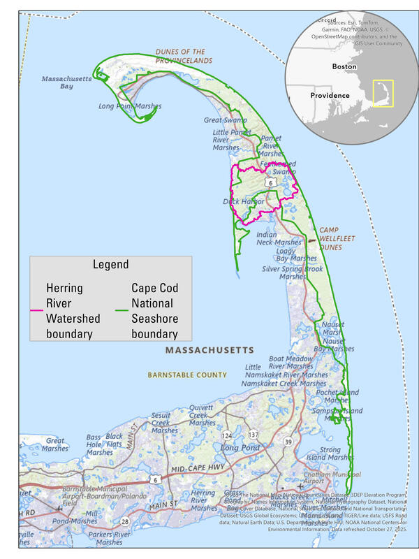
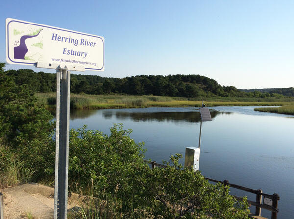
The Herring River is the largest river within Cape Cod National Seashore (CACO) and, historically, one of the most significant tidal rivers on outer Cape Cod. The river has been diked off from the ocean since 1909 with the construction of tidal restrictions on Chequessett Neck Road, hereafter referred to as the CNR dike. The tidal restrictions have resulted in environmental degradation including the loss of estuarine habitat and salt marsh vegetation (NPS, 2016).
In response to the negative environmental impacts of diking the Herring River approximately 100 years ago, CACO is leading a multi-agency team to restore tidal flow to the estuary. One anticipated benefit of restoration will be improved water quality in the estuary (NPS, 2016).
There are also possible impacts on sediment and nutrient loads to Wellfleet Harbor, which supports a thriving aquaculture industry (Town of Wellfleet, 2011). It is critical to document the pre-restoration range of variability among the pertinent water-quality constituents so that any post-restoration changes can be credibly attributed to project-related activities or other independent factors.
Learn more about the restoration project through National Park Service or Friends of the Herring River.
Historical Monitoring
A recent effort has been made to compile and publish existing water-quality data collected in the Herring River estuary to characterize pre-restoration conditions. Early monitoring in the Herring River began in 1984 by CACO NPS staff. This early monitoring effort focused on dissolved oxygen (DO) concentrations because low DO was identified as the primary cause of emigrating river herring die-offs (Portnoy, 1991).
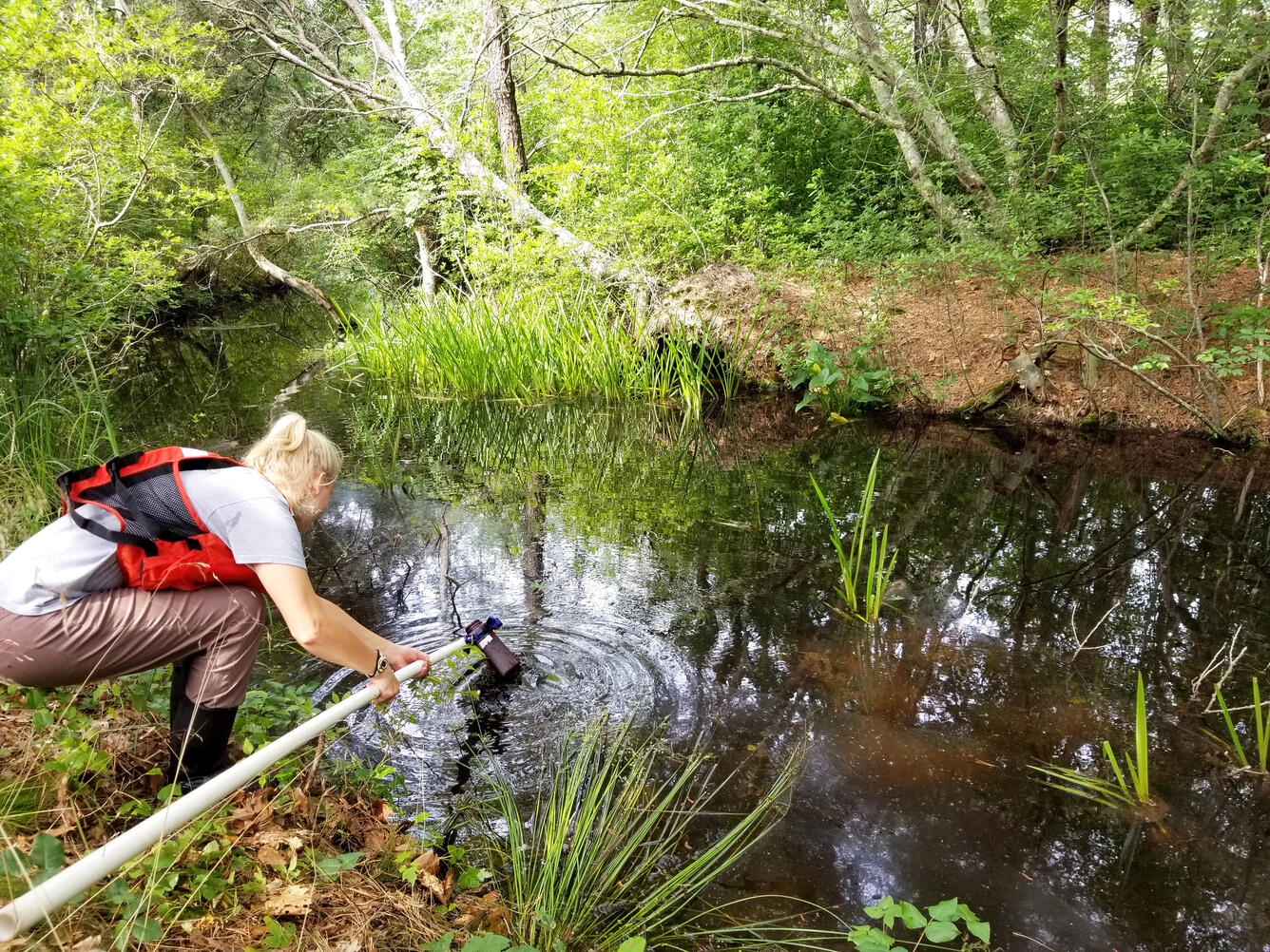
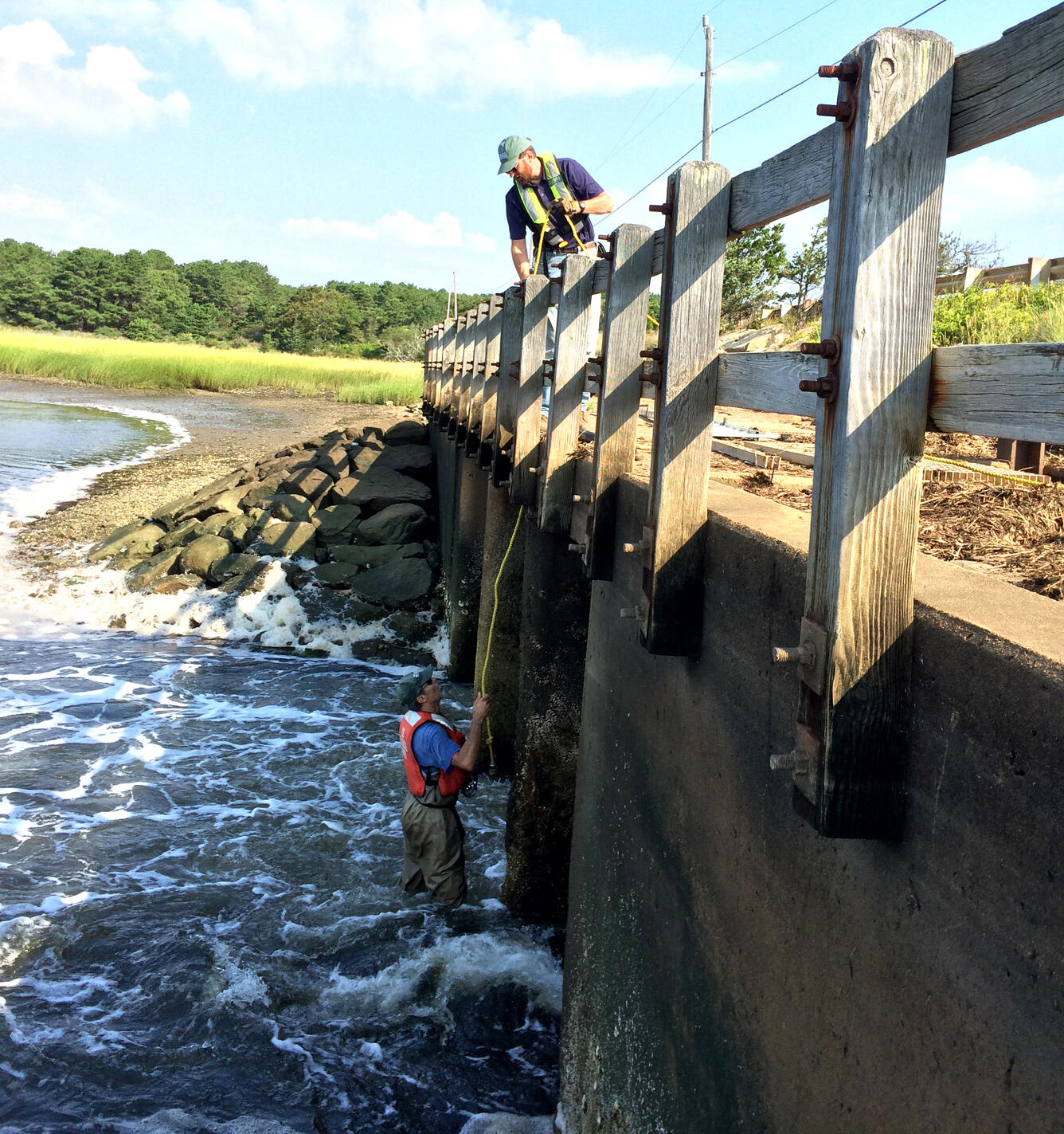
In 2006, CACO scientists began a larger monitoring effort which included monthly sample collection at 11 sites in the Herring River estuary. Samples were analyzed for concentrations of sediment, chlorophyll, nitrogen, and phosphorus. This monitoring program continues to present. Data are published through 2017 in this USGS data release (Spaetzel et al., 2020).
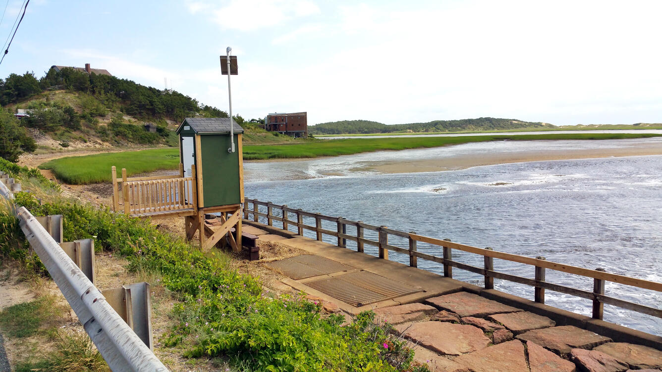
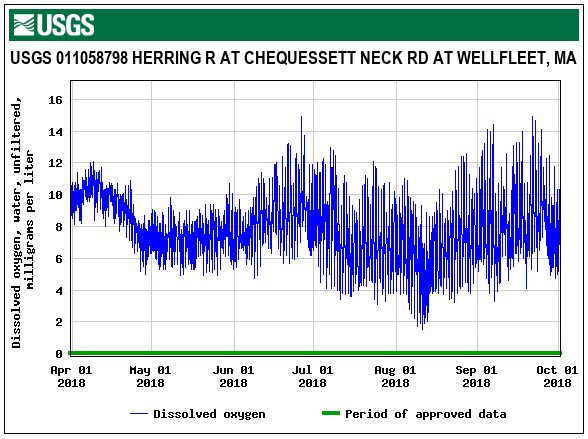
In 2015, CACO NPS and the U.S. Geological Survey partnered to implement continuous water-quality monitoring and flow-weighted composite sampling on the dike itself. Continuous monitoring equipment on either side of the dike captured real-time conditions, including water level, specific conductance, temperature, dissolved oxygen, and pH.
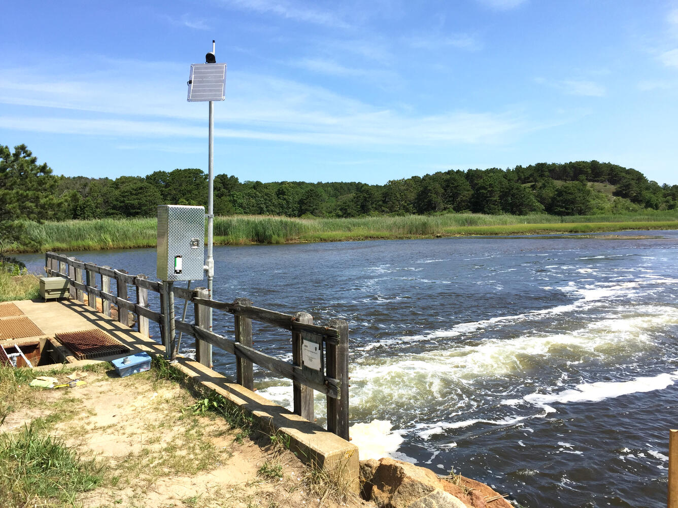
On the downstream side of the CNR dike, water-quality samples were collected flow-proportionally from November 2015 through September 2018. The samples were analyzed for concentrations of sediment and nutrients to characterize seasonal and annual variability.
Explore
Exactly 2,151 samples have been collected in the Herring River estuary since 2006.
Some areas in the estuary have been more heavily monitored than others, like the dike itself.
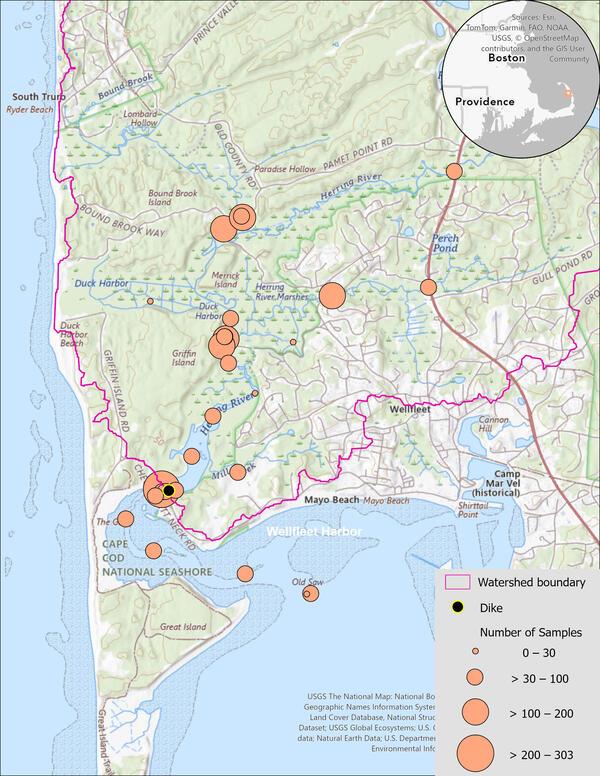
The majority of samples are grab samples which capture conditions at a single point in time. At three sites, automated samplers were installed to collect composite samples which capture conditions over a range in flow conditions or time.

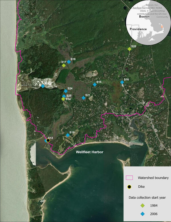
Three sites were established in 1984 to monitor dissolved oxygen concentrations.
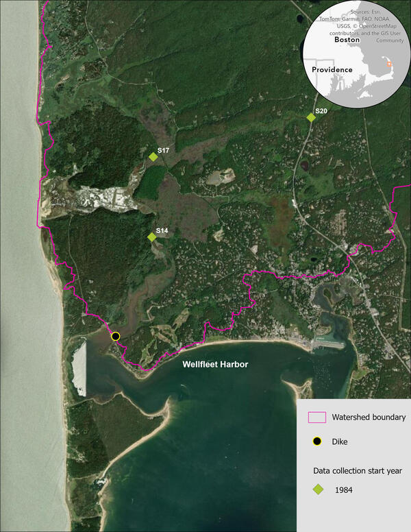
In 2006, 7 new sites were established by NPS for monthly nutrient and sediment sampling.
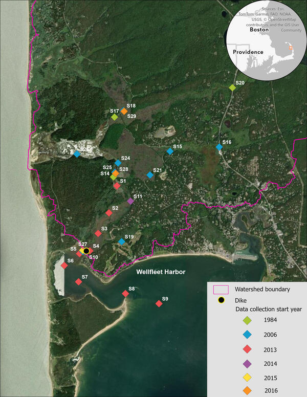
Between the years of 2013 and 2016, 18 new sites were established, most for short-term projects.
USGS data are available on the National Water Information System (NWIS).
Nine sites were actively monitored in 2019 by CACO staff, including the three sites established in 1984.
Anticipated work in 2020 includes USGS monitoring at the dike stations.
CACO data can be downloaded here. Field parameters and laboratory results are stored in separate comma separated value (.csv) files.

Summary
The Herring River has been diked for more than 100 years which has restricted tidal flow and degraded water quality. An ongoing restoration project led by Cape Cod National Seashore requires historical and current monitoring to characterize water-quality conditions pre-restoration.
Monitoring programs in the 1980s and from 2006 to 2019 have compiled a large base of water-quality data that were published in 2020.
Credits and References
Story map originally published on April 10, 2020.
Recreated as a Drupal Story on January 21, 2026.
Author: Alana B. Spaetzel
All photographs by U.S. Geological Survey.
Any use of trade, firm, or product names is for descriptive purposes only and does not imply endorsement by the U.S. Government.
References Cited
National Park Service, Town of Wellfleet, Town of Truro, and Herring River Restoration Committee, 2016, Herring River restoration project—Final environmental impact statement/environmental impact report, May 2016: National Park Service Environmental Impact Statement/Report , 388 p., accessed January 2018 at https://parkplanning.nps.gov/document.cfm?parkID=217&projectID=18573&documentID=73471.
Portnoy, J.W., 1991, Summer oxygen depletion in a diked New England estuary: Estuaries, v. 14, no. 2, p. 122-129. [Also available at https://doi.org/10.2307/1351685.]
Spaetzel, A.B., Huntington, T.G., and Fox, S.E., 2020, Discrete water-quality data supporting Herring River restoration project, Cape Cod National Seashore, 1984-2017: U.S. Geological Survey data release, https://doi.org/10.5066/P95GY3R6.
Town of Wellfleet, 2011, Project work plan for Wellfleet Harbor oyster spawning project: Town of Wellfleet, Massachusetts, prepared by Environmental Partners, Inc., variously paged, accessed January 2018 at https://www.wellfleet-ma.gov/sites/g/files/vyhlif16026/f/file/file/oyster_spawning_project_4-11-11.pdf.

Herring River Water Quality
This storytelling explores the availability of water-quality data collected by the Cape Cod National Seashore and U.S. Geological Survey in support of the Herring River restoration project. It highlights the development of the monitoring program since the 1980s and the publication of Cape Cod National Seashore data in a U.S. Geological Survey data release.
The U.S. Geological Survey (USGS) New England Water Science Center installed, operated, and maintained surface water-quality sites at the Chequessett Neck Road dike on the Herring River from November 2015 through September 2018.
The goals of the data collection program were to establish a pre-restoration baseline water quality-dataset and to characterize concentrations of nutrients and other water-quality indicators in the estuary.
These data provide critical information and feedback needed as part of the adaptive management process being taken to guide management decisions and measure progress toward restoration objectives for the Herring River saltmarsh.
The data collected between November 2015 and September 2017 are included in a USGS Scientific Investigations Report and all data through September 2018 are published in the National Water Information System. A USGS data release makes water-quality data collected by Cape Cod National Seashore from 1984 through 2017 publicly available.
Background
The Herring River is the largest river within Cape Cod National Seashore (CACO) and, historically, one of the most significant tidal rivers on outer Cape Cod. The river has been diked off from the ocean since 1909 with the construction of tidal restrictions on Chequessett Neck Road, hereafter referred to as the CNR dike. The tidal restrictions have resulted in environmental degradation including the loss of estuarine habitat and salt marsh vegetation (NPS, 2016).
In response to the negative environmental impacts of diking the Herring River approximately 100 years ago, CACO is leading a multi-agency team to restore tidal flow to the estuary. One anticipated benefit of restoration will be improved water quality in the estuary (NPS, 2016).
There are also possible impacts on sediment and nutrient loads to Wellfleet Harbor, which supports a thriving aquaculture industry (Town of Wellfleet, 2011). It is critical to document the pre-restoration range of variability among the pertinent water-quality constituents so that any post-restoration changes can be credibly attributed to project-related activities or other independent factors.
Learn more about the restoration project through National Park Service or Friends of the Herring River.
Historical Monitoring
A recent effort has been made to compile and publish existing water-quality data collected in the Herring River estuary to characterize pre-restoration conditions. Early monitoring in the Herring River began in 1984 by CACO NPS staff. This early monitoring effort focused on dissolved oxygen (DO) concentrations because low DO was identified as the primary cause of emigrating river herring die-offs (Portnoy, 1991).
In 2006, CACO scientists began a larger monitoring effort which included monthly sample collection at 11 sites in the Herring River estuary. Samples were analyzed for concentrations of sediment, chlorophyll, nitrogen, and phosphorus. This monitoring program continues to present. Data are published through 2017 in this USGS data release (Spaetzel et al., 2020).
In 2015, CACO NPS and the U.S. Geological Survey partnered to implement continuous water-quality monitoring and flow-weighted composite sampling on the dike itself. Continuous monitoring equipment on either side of the dike captured real-time conditions, including water level, specific conductance, temperature, dissolved oxygen, and pH.
On the downstream side of the CNR dike, water-quality samples were collected flow-proportionally from November 2015 through September 2018. The samples were analyzed for concentrations of sediment and nutrients to characterize seasonal and annual variability.
Explore
Exactly 2,151 samples have been collected in the Herring River estuary since 2006.
Some areas in the estuary have been more heavily monitored than others, like the dike itself.
The majority of samples are grab samples which capture conditions at a single point in time. At three sites, automated samplers were installed to collect composite samples which capture conditions over a range in flow conditions or time.
Three sites were established in 1984 to monitor dissolved oxygen concentrations.
In 2006, 7 new sites were established by NPS for monthly nutrient and sediment sampling.
Between the years of 2013 and 2016, 18 new sites were established, most for short-term projects.
USGS data are available on the National Water Information System (NWIS).
Nine sites were actively monitored in 2019 by CACO staff, including the three sites established in 1984.
Anticipated work in 2020 includes USGS monitoring at the dike stations.
CACO data can be downloaded here. Field parameters and laboratory results are stored in separate comma separated value (.csv) files.
Summary
The Herring River has been diked for more than 100 years which has restricted tidal flow and degraded water quality. An ongoing restoration project led by Cape Cod National Seashore requires historical and current monitoring to characterize water-quality conditions pre-restoration.
Monitoring programs in the 1980s and from 2006 to 2019 have compiled a large base of water-quality data that were published in 2020.
Credits and References
Story map originally published on April 10, 2020.
Recreated as a Drupal Story on January 21, 2026.
Author: Alana B. Spaetzel
All photographs by U.S. Geological Survey.
Any use of trade, firm, or product names is for descriptive purposes only and does not imply endorsement by the U.S. Government.
References Cited
National Park Service, Town of Wellfleet, Town of Truro, and Herring River Restoration Committee, 2016, Herring River restoration project—Final environmental impact statement/environmental impact report, May 2016: National Park Service Environmental Impact Statement/Report , 388 p., accessed January 2018 at https://parkplanning.nps.gov/document.cfm?parkID=217&projectID=18573&documentID=73471.
Portnoy, J.W., 1991, Summer oxygen depletion in a diked New England estuary: Estuaries, v. 14, no. 2, p. 122-129. [Also available at https://doi.org/10.2307/1351685.]
Spaetzel, A.B., Huntington, T.G., and Fox, S.E., 2020, Discrete water-quality data supporting Herring River restoration project, Cape Cod National Seashore, 1984-2017: U.S. Geological Survey data release, https://doi.org/10.5066/P95GY3R6.
Town of Wellfleet, 2011, Project work plan for Wellfleet Harbor oyster spawning project: Town of Wellfleet, Massachusetts, prepared by Environmental Partners, Inc., variously paged, accessed January 2018 at https://www.wellfleet-ma.gov/sites/g/files/vyhlif16026/f/file/file/oyster_spawning_project_4-11-11.pdf.