
A map of the Katahdin Woods and Waters National Monument in Maine.
Thermal Imaging to Detect Cold-Water Habitat for Atlantic Salmon and Brook Trout at Katahdin Woods and Waters National Monument
Active
By New England Water Science Center
May 27, 2026
The U.S. Geological Survey (USGS), in cooperation with the National Park Service (NPS), is using airborne thermal infrared remote sensing to characterize cold-water habitat for the federally designated endangered species Atlantic salmon (Salmo salar) and wild brook trout (Salvelinus fontinalis) in the East Branch of the Penobscot River system within Katahdin Woods and Waters National Monument (the monument). This watershed is among the least developed in the continental United States and provides critical habitat for coldwater fish species. The persistence of this habitat depends, in part, on proactive management by the NPS, informed by scientific research and monitoring conducted by the USGS and other agencies.
Media
Sources/Usage: Public Domain. View Media Details
In 2016, NPS established Katahdin Woods and Waters National Monument to “preserve the nationally significant natural, cultural, and ecological resources associated with Maine’s North Woods” and to “safeguard the character of the free-flowing and scenic rivers and streams within its boundaries,” according to the park’s foundation document. The monument is located on the present and ancestral homelands of the Penobscot Nation and includes the East Branch of the Penobscot River and its tributaries, the Wassataquoik Stream and Seboeis River. There is an urgent need to locate cold-water sections of the monument's major rivers and tributaries that provide the most crucial habitat to threatened species, and detailed thermal imagery is a highly effective and efficient way to map these areas.
Cold-water refuges are patches of cool water that are used for temperature relief and survival by thermally sensitive species, including Atlantic salmon and wild brook trout. These cooler areas form where groundwater and smaller tributaries enter the river channel. Cold groundwater zones provide thermally stable, oxygen-rich habitats that are critical for reducing summer thermal stress, supporting successful reproduction, and sustaining trout populations under changing climate and flow conditions. River barriers within Katahdin Woods and Waters National Monument (e.g., culverts, drainage crossings, and dams) can impede flow and restrict fish from accessing cold-water refuges. Therefore, characterizing the most critical cold-water refuge sites in this study will enable the monument to focus on long-term protection of these areas through priority management actions such as improving aquatic passages, restoring habitat, or targeting regulatory changes.
This collaborative study will provide NPS and partners with the information needed to identify potential cold-water habitat for Atlantic salmon and wild brook trout. The monument will also use these data to inform Katahdin Woods and Waters National Monument's General Management Plan (GMP), which is currently under development.
Media
Sources/Usage: Public Domain. View Media Details
Objectives
Media
Sources/Usage: Public Domain. View Media Details
The primary objective of this study is to identify and characterize potential cold-water habitat for Atlantic salmon and wild brook trout in Katahdin Woods and Waters National Monument using thermal infrared (TIR) imaging, with the goal of informing habitat protection and management decisions. To support this effort, TIR and natural color (RGB) imagery will be collected along the upper East Branch of the Penobscot River and its tributaries using a helicopter and handheld sensor. Prior to the aerial TIR survey, USGS, NPS, and project partners will deploy temperature data loggers throughout the river system to support calibration and validation of the remotely sensed data.
Data acquisition will occur in late summer under optimal environmental conditions —clear skies, low humidity, minimal wind, low streamflow, and no recent precipitation—to ensure data quality and consistency. The team will also coordinate with Matagamon Dam to ensure data collection does not happen during a dam release. Establishing this baseline dataset is essential for the monument's resource managers, enabling informed decision-making to protect and sustain cold-water refuges that are critical to the health of native fish populations.
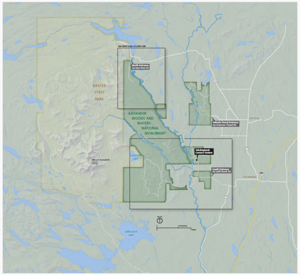
Katahdin Woods and Waters National Monument Map
A map of the Katahdin Woods and Waters National Monument in Maine.

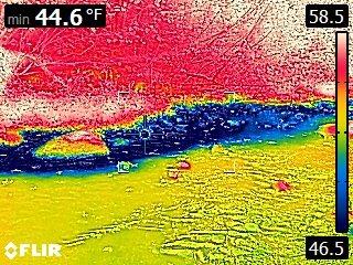
Thermal Image of Groundwater from Bank Discharging into Stream
Thermal Image of Groundwater from Bank Discharging into StreamA thermal image taken with a handheld FLIR camera showing approximate water temperature, where warmer temperatures are represented as red and cooler temperatures as blue. This image presents an approximately 20-foot area where cooler groundwater (blue) may be discharging from a bank into a warm stream in early September.

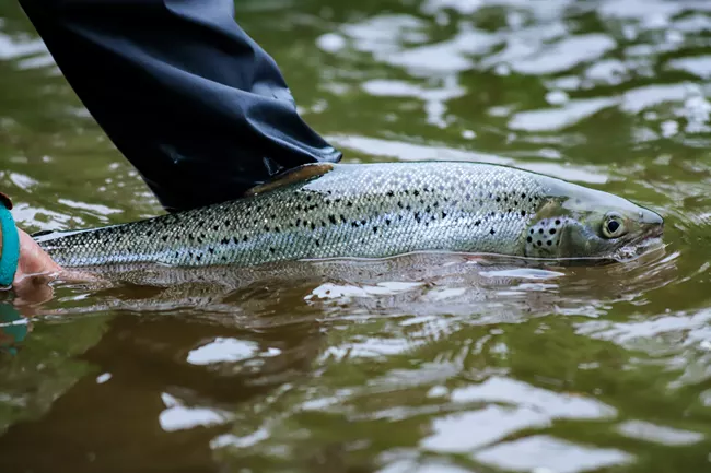
Atlantic Salmon Released into the East Branch of the Penobscot River
Atlantic Salmon Released into the East Branch of the Penobscot RiverThe East Branch of the Penobscot River provides high-quality habitat for the endangered Atlantic Salmon, and preserving the habitat in the Katahdin Woods and Waters National Monument is important for the river's ecosystem. Thousands of hatchery-spawned Atlantic salmon into the East Branch of the Penobscot River in 2023.

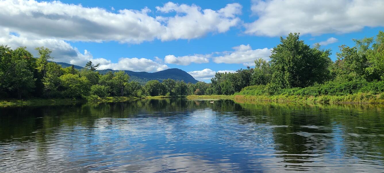
Panoramic view of the East Branch Penobscot River from the Big Seboeis Area
Panoramic view of the East Branch Penobscot River from the Big Seboeis AreaPanoramic view of the East Branch Penobscot River from the Big Seboeis area within the Katahdin Woods and Water National Monument in Maine.
Panoramic view of the East Branch Penobscot River from the Big Seboeis Area
Panoramic view of the East Branch Penobscot River from the Big Seboeis AreaPanoramic view of the East Branch Penobscot River from the Big Seboeis area within the Katahdin Woods and Water National Monument in Maine.
The U.S. Geological Survey (USGS), in cooperation with the National Park Service (NPS), is using airborne thermal infrared remote sensing to characterize cold-water habitat for the federally designated endangered species Atlantic salmon (Salmo salar) and wild brook trout (Salvelinus fontinalis) in the East Branch of the Penobscot River system within Katahdin Woods and Waters National Monument (the monument). This watershed is among the least developed in the continental United States and provides critical habitat for coldwater fish species. The persistence of this habitat depends, in part, on proactive management by the NPS, informed by scientific research and monitoring conducted by the USGS and other agencies.
Media
Sources/Usage: Public Domain. View Media Details
In 2016, NPS established Katahdin Woods and Waters National Monument to “preserve the nationally significant natural, cultural, and ecological resources associated with Maine’s North Woods” and to “safeguard the character of the free-flowing and scenic rivers and streams within its boundaries,” according to the park’s foundation document. The monument is located on the present and ancestral homelands of the Penobscot Nation and includes the East Branch of the Penobscot River and its tributaries, the Wassataquoik Stream and Seboeis River. There is an urgent need to locate cold-water sections of the monument's major rivers and tributaries that provide the most crucial habitat to threatened species, and detailed thermal imagery is a highly effective and efficient way to map these areas.
Cold-water refuges are patches of cool water that are used for temperature relief and survival by thermally sensitive species, including Atlantic salmon and wild brook trout. These cooler areas form where groundwater and smaller tributaries enter the river channel. Cold groundwater zones provide thermally stable, oxygen-rich habitats that are critical for reducing summer thermal stress, supporting successful reproduction, and sustaining trout populations under changing climate and flow conditions. River barriers within Katahdin Woods and Waters National Monument (e.g., culverts, drainage crossings, and dams) can impede flow and restrict fish from accessing cold-water refuges. Therefore, characterizing the most critical cold-water refuge sites in this study will enable the monument to focus on long-term protection of these areas through priority management actions such as improving aquatic passages, restoring habitat, or targeting regulatory changes.
This collaborative study will provide NPS and partners with the information needed to identify potential cold-water habitat for Atlantic salmon and wild brook trout. The monument will also use these data to inform Katahdin Woods and Waters National Monument's General Management Plan (GMP), which is currently under development.
Media
Sources/Usage: Public Domain. View Media Details
Objectives
Media
Sources/Usage: Public Domain. View Media Details
The primary objective of this study is to identify and characterize potential cold-water habitat for Atlantic salmon and wild brook trout in Katahdin Woods and Waters National Monument using thermal infrared (TIR) imaging, with the goal of informing habitat protection and management decisions. To support this effort, TIR and natural color (RGB) imagery will be collected along the upper East Branch of the Penobscot River and its tributaries using a helicopter and handheld sensor. Prior to the aerial TIR survey, USGS, NPS, and project partners will deploy temperature data loggers throughout the river system to support calibration and validation of the remotely sensed data.
Data acquisition will occur in late summer under optimal environmental conditions —clear skies, low humidity, minimal wind, low streamflow, and no recent precipitation—to ensure data quality and consistency. The team will also coordinate with Matagamon Dam to ensure data collection does not happen during a dam release. Establishing this baseline dataset is essential for the monument's resource managers, enabling informed decision-making to protect and sustain cold-water refuges that are critical to the health of native fish populations.
Katahdin Woods and Waters National Monument Map
A map of the Katahdin Woods and Waters National Monument in Maine.
A map of the Katahdin Woods and Waters National Monument in Maine.
Thermal Image of Groundwater from Bank Discharging into Stream
Thermal Image of Groundwater from Bank Discharging into StreamA thermal image taken with a handheld FLIR camera showing approximate water temperature, where warmer temperatures are represented as red and cooler temperatures as blue. This image presents an approximately 20-foot area where cooler groundwater (blue) may be discharging from a bank into a warm stream in early September.
Atlantic Salmon Released into the East Branch of the Penobscot River
Atlantic Salmon Released into the East Branch of the Penobscot RiverThe East Branch of the Penobscot River provides high-quality habitat for the endangered Atlantic Salmon, and preserving the habitat in the Katahdin Woods and Waters National Monument is important for the river's ecosystem. Thousands of hatchery-spawned Atlantic salmon into the East Branch of the Penobscot River in 2023.
Panoramic view of the East Branch Penobscot River from the Big Seboeis Area
Panoramic view of the East Branch Penobscot River from the Big Seboeis AreaPanoramic view of the East Branch Penobscot River from the Big Seboeis area within the Katahdin Woods and Water National Monument in Maine.
Panoramic view of the East Branch Penobscot River from the Big Seboeis Area
Panoramic view of the East Branch Penobscot River from the Big Seboeis AreaPanoramic view of the East Branch Penobscot River from the Big Seboeis area within the Katahdin Woods and Water National Monument in Maine.