



Thermal Image of Groundwater from Bank Discharging into Stream
By New England Water Science Center
September 2025 (approx.)

Detailed Description
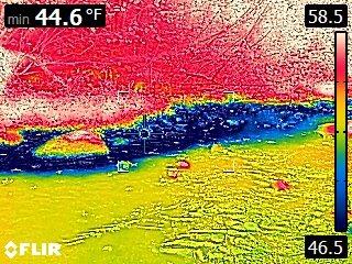
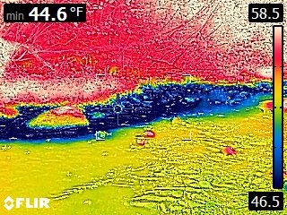
A thermal image taken with a handheld FLIR camera showing approximate water temperature, where warmer temperatures are represented as red and cooler temperatures as blue. This image presents an approximately 20-foot area where cooler groundwater (blue) may be discharging from a bank into a warm stream in early September. The temperature scale is in degrees Fahrenheit.
Sources/Usage
Public Domain.
Related
Thermal Imaging to Detect Cold-Water Habitat for Atlantic Salmon and Brook Trout at Katahdin Woods and Waters National Monument
The U.S. Geological Survey (USGS), in cooperation with the National Park Service (NPS), is using airborne thermal infrared remote sensing to characterize cold-water habitat for the federally designated endangered species Atlantic salmon ( Salmo salar) and wild brook trout ( Salvelinus fontinalis) in the East Branch of the Penobscot River system within Katahdin Woods and Waters National Monument...
Thermal Imagery to Inform Brook Trout Habitat Suitability and Restoration Potential, Upper Namekagon River, Wisconsin
The U.S. Geological Survey (USGS), in cooperation with the National Park Service (NPS), is using thermal infrared technology to identify cold-water habitat for brook trout and other cold-water species in the upper Namekagon River in Wisconsin. The upper Namekagon River and its tributaries have long served as a stronghold for brook trout and other cold- and cool-water species; however, changing...
Related
Thermal Imaging to Detect Cold-Water Habitat for Atlantic Salmon and Brook Trout at Katahdin Woods and Waters National Monument
The U.S. Geological Survey (USGS), in cooperation with the National Park Service (NPS), is using airborne thermal infrared remote sensing to characterize cold-water habitat for the federally designated endangered species Atlantic salmon ( Salmo salar) and wild brook trout ( Salvelinus fontinalis) in the East Branch of the Penobscot River system within Katahdin Woods and Waters National Monument...
Thermal Imagery to Inform Brook Trout Habitat Suitability and Restoration Potential, Upper Namekagon River, Wisconsin
The U.S. Geological Survey (USGS), in cooperation with the National Park Service (NPS), is using thermal infrared technology to identify cold-water habitat for brook trout and other cold-water species in the upper Namekagon River in Wisconsin. The upper Namekagon River and its tributaries have long served as a stronghold for brook trout and other cold- and cool-water species; however, changing...