
Streamflow data are needed at many sites on a daily basis for forecasting flow extremes, making water-management decisions, assessing current water availability, managing water quality, and meeting legal requirements. These activities require streamflow information at a given location for a specified time. These needs generally are best satisfied by operating a station to produce a continuous record of flow. The locations of the stations and the periods of operation are dictated by the uses to be made of the data. More than one-half of the USGS stations provide current information to agencies that operate water-resource systems and forecast floods.
Quick Links:
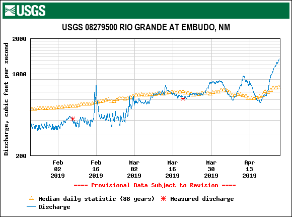
USGS Current Water Data for New Mexico
USGS Water Data for the Nation
USGS Surface-Water Historical Instantaneous Data for the Nation

Approach:
- Locate streamgages along major tributaries of rivers and streams to assess discharge
- Provide long-term data for flood frequency prediction, and for flow patterns within various river basins
- Respond to flood events to characterize flow regime in ephemeral, intermittent, and perennial channels

Objectives:
The USGS stream-gaging program provides hydrologic information needed to help define, use, and manage the Nation's water resources. The program provides a continuous, well-documented, well-archived, unbiased, and broad-based source of reliable and consistent water data.
Streamflow data are needed at many sites on a daily basis for forecasting flow extremes, making water-management decisions, assessing current water availability, managing water quality, and meeting legal requirements. These activities require streamflow information at a given location for a specified time. These needs generally are best satisfied by operating a station to produce a continuous record of flow. The locations of the stations and the periods of operation are dictated by the uses to be made of the data. More than one-half of the USGS stations provide current information to agencies that operate water-resource systems and forecast floods.
Quick Links:
USGS Current Water Data for New Mexico
USGS Water Data for the Nation
USGS Surface-Water Historical Instantaneous Data for the Nation
Approach:
- Locate streamgages along major tributaries of rivers and streams to assess discharge
- Provide long-term data for flood frequency prediction, and for flow patterns within various river basins
- Respond to flood events to characterize flow regime in ephemeral, intermittent, and perennial channels
Objectives:
The USGS stream-gaging program provides hydrologic information needed to help define, use, and manage the Nation's water resources. The program provides a continuous, well-documented, well-archived, unbiased, and broad-based source of reliable and consistent water data.