
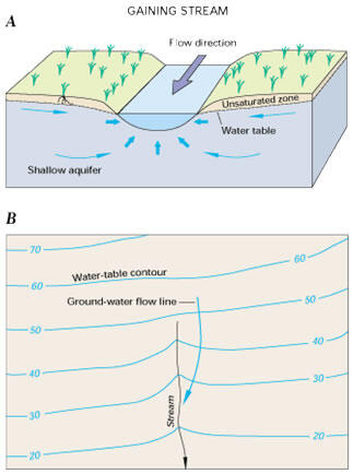
Streams either gain water from inflow of groundwater from the underlying aquifer or lose water by outflow to the underlying aquifer. Many streams do both, gaining in some reaches and losing in other reaches. Furthermore, the groundwater flow directions near any given stream can change seasonally as the altitude of the water table changes with respect to the stream-surface altitude or when rapid rises in stream stage during storms cause recharge to the streambank (known as “bank storage”). Under natural conditions, groundwater makes some contribution to streamflow in most physiographic and climatic settings.
In overall aspect, the present locations of Long Island's streams were determined mainly by the ancient drainage pattern that developed during the last ice age. Accordingly, most of the streams flow in broad, shallow valleys that were formed by the much larger streams which existed during melting of the ice sheet. All the southward-flowing streams have gentle gradients that, throughout most of their reaches, average about 10 feet per mile. The northward-flowing streams generally have steeper gradients that average about 20-40 feet per mile (Cohen and others, 1968).
Two distinctly different types of natural lakes and ponds are found on Long Island — water-table and perched lakes and ponds. Lake Ronkonkoma is a water-table lake, its bottom extending to a depth of about 60 feet below the water table. Lake Success is one of the better known examples of a perched lake on Long Island. Both of these lakes and many other natural lakes and ponds on Long Island, including Lake Panamoka, in Ridge, N.Y. are sometimes referred to as "kettle-hole" lakes. Such lakes fill depressions formed by blocks of ice that were buried during the last ice age and subsequently melted. Numerous artificial lakes and ponds have been built on Long Island. The larger ones were formed by the construction of low dams across streams. Hempstead and Belmont Lakes are well known examples of this type of lake (Cohen and others, 1968).
During the 19th and the early part of the 20th century, Long Island's streams, lakes, and ponds were used extensively as sources of water supply and for power to operate sawmills and gristmills. Presently, only insignificant quantities of surface water are used for water supply, and all the mills have been long since abandoned, except for several preserved as museums. The surface-water bodies of Long Island are, however, used extensively for recreation.
Location of the streams and selected gaging stations are shown in figure 10:

Winter and others (1998) provides a thorough description of the interaction of groundwater and streams, lakes and wetlands (figures 11A and 11B). On Long Island streams gain water from inflow of groundwater through the streambed.
_______________________________
Table of Contents
Below are other science projects associated with this project.

Hydrologic Cycle

Long Island Precipitation and Recharge

Long Island Groundwater

Long Island Hydrogeologic Units

Long Island Fresh and Saltwater Relations/Interactions
Streams either gain water from inflow of groundwater from the underlying aquifer or lose water by outflow to the underlying aquifer. Many streams do both, gaining in some reaches and losing in other reaches. Furthermore, the groundwater flow directions near any given stream can change seasonally as the altitude of the water table changes with respect to the stream-surface altitude or when rapid rises in stream stage during storms cause recharge to the streambank (known as “bank storage”). Under natural conditions, groundwater makes some contribution to streamflow in most physiographic and climatic settings.
In overall aspect, the present locations of Long Island's streams were determined mainly by the ancient drainage pattern that developed during the last ice age. Accordingly, most of the streams flow in broad, shallow valleys that were formed by the much larger streams which existed during melting of the ice sheet. All the southward-flowing streams have gentle gradients that, throughout most of their reaches, average about 10 feet per mile. The northward-flowing streams generally have steeper gradients that average about 20-40 feet per mile (Cohen and others, 1968).
Two distinctly different types of natural lakes and ponds are found on Long Island — water-table and perched lakes and ponds. Lake Ronkonkoma is a water-table lake, its bottom extending to a depth of about 60 feet below the water table. Lake Success is one of the better known examples of a perched lake on Long Island. Both of these lakes and many other natural lakes and ponds on Long Island, including Lake Panamoka, in Ridge, N.Y. are sometimes referred to as "kettle-hole" lakes. Such lakes fill depressions formed by blocks of ice that were buried during the last ice age and subsequently melted. Numerous artificial lakes and ponds have been built on Long Island. The larger ones were formed by the construction of low dams across streams. Hempstead and Belmont Lakes are well known examples of this type of lake (Cohen and others, 1968).
During the 19th and the early part of the 20th century, Long Island's streams, lakes, and ponds were used extensively as sources of water supply and for power to operate sawmills and gristmills. Presently, only insignificant quantities of surface water are used for water supply, and all the mills have been long since abandoned, except for several preserved as museums. The surface-water bodies of Long Island are, however, used extensively for recreation.
Location of the streams and selected gaging stations are shown in figure 10:
Winter and others (1998) provides a thorough description of the interaction of groundwater and streams, lakes and wetlands (figures 11A and 11B). On Long Island streams gain water from inflow of groundwater through the streambed.
_______________________________
Table of Contents
Below are other science projects associated with this project.
Hydrologic Cycle
Long Island Precipitation and Recharge
Long Island Groundwater
Long Island Hydrogeologic Units