
Urban Waters Federal Partnership - Edwards Aquifer Recharge Zone Monitoring Network
Contaminants in the Edwards aquifer
Where do they come from and how do they get there?
The USGS Oklahoma-Texas Water Science Center is implementing a more complete and integrated monitoring network for the Edwards aquifer to improve the understanding of aquifer water quality and establish a baseline for measuring future water-quality changes.
Data from this study can be used to address these primary objectives:
- Long-term trends in water quality, with particular emphasis on nutrients and organic contaminants including pesticides, pharmaceuticals, and wastewater compounds.
- How surface water - groundwater interaction affects water quality changes over a range of hydrologic conditions.
› Learn more about the Edwards Aquifer Urban Hydrology Network
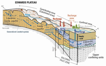
The San Antonio segment of the Edwards aquifer (hereafter, the Edwards aquifer), located in south-central Texas is a karst groundwater system that provides important water resources to the region, provides habitat for endemic and endangered species, and supplies major spring systems such as Comal Springs and San Marcos Springs.
In the face of increasing pressures from urbanization, a better understanding of the sources, fate, and transport of anthropogenic contaminants in the aquifer is needed to improve water management decision-making capabilities.
Additionally, the role of surface water-groundwater interaction, and effects on water quality under a range of flow conditions, is needed to understand urbanization impacts to the aquifer. Sources of anthropogenic constituents to the aquifer, such as nutrients, pesticides, pharmaceuticals, and other wastewater compounds and the influences of different land-cover types, are largely unknown.
Approach

An approach integrating real-time data logging, discrete sample collection, and automated sampling is being used to obtain water-quality data on major ions, nutrients, organic contaminants, and selected isotopes (hydrogen, oxygen, nitrogen, and strontium) in rainfall, recharging surface water, unconfined groundwater, confined groundwater, and spring discharge.
Continuous surface-water and groundwater measurements
Selected sites will include:
- Precipitation collection sites on the urbanized and rural portion of the Edwards aquifer recharge zone
- Surface water sites, selected to represent urban and rural surface-water runoff
- Groundwater sites with contrasting properties, including urban and rural settings and shallow unconfined and deeper confined groundwater wells
- Comal spring #1 –a major discharge point of the aquifer and integrator of regional aquifer flowpaths
Routine sampling
Routine samples have been collected at regular intervals through multiple years with the objective of covering a range of aquifer flow conditions.
Event-based sampling
Event-based samples have been collected in response to storm events from surface water sites, groundwater sites, and the spring discharge site. Additionally, precipitation samples have been collected and characterized for water quality.
More about other Urban Waters Federal Partnership projects
Below are other science projects associated with this project.

Urban Waters Federal Partnership - Edwards Aquifer Recharge in a Developing Landscape

Urban Waters Federal Partnership - Suspended Sediment and Nutrient Delivery to the Gulf of America

Edwards Aquifer Recharge Zone Surface-water and Groundwater Interaction

National Water-Quality Assessment Project in Texas - Surface Water Activities

Edwards Aquifer Groundwater Model Uncertainty Analysis
The USGS Oklahoma-Texas Water Science Center is implementing a more complete and integrated monitoring network for the Edwards aquifer to improve the understanding of aquifer water quality and establish a baseline for measuring future water-quality changes.
Data from this study can be used to address these primary objectives:
- Long-term trends in water quality, with particular emphasis on nutrients and organic contaminants including pesticides, pharmaceuticals, and wastewater compounds.
- How surface water - groundwater interaction affects water quality changes over a range of hydrologic conditions.
› Learn more about the Edwards Aquifer Urban Hydrology Network
The San Antonio segment of the Edwards aquifer (hereafter, the Edwards aquifer), located in south-central Texas is a karst groundwater system that provides important water resources to the region, provides habitat for endemic and endangered species, and supplies major spring systems such as Comal Springs and San Marcos Springs.
In the face of increasing pressures from urbanization, a better understanding of the sources, fate, and transport of anthropogenic contaminants in the aquifer is needed to improve water management decision-making capabilities.
Additionally, the role of surface water-groundwater interaction, and effects on water quality under a range of flow conditions, is needed to understand urbanization impacts to the aquifer. Sources of anthropogenic constituents to the aquifer, such as nutrients, pesticides, pharmaceuticals, and other wastewater compounds and the influences of different land-cover types, are largely unknown.
Approach
An approach integrating real-time data logging, discrete sample collection, and automated sampling is being used to obtain water-quality data on major ions, nutrients, organic contaminants, and selected isotopes (hydrogen, oxygen, nitrogen, and strontium) in rainfall, recharging surface water, unconfined groundwater, confined groundwater, and spring discharge.
Continuous surface-water and groundwater measurements
Selected sites will include:
- Precipitation collection sites on the urbanized and rural portion of the Edwards aquifer recharge zone
- Surface water sites, selected to represent urban and rural surface-water runoff
- Groundwater sites with contrasting properties, including urban and rural settings and shallow unconfined and deeper confined groundwater wells
- Comal spring #1 –a major discharge point of the aquifer and integrator of regional aquifer flowpaths
Routine sampling
Routine samples have been collected at regular intervals through multiple years with the objective of covering a range of aquifer flow conditions.
Event-based sampling
Event-based samples have been collected in response to storm events from surface water sites, groundwater sites, and the spring discharge site. Additionally, precipitation samples have been collected and characterized for water quality.
More about other Urban Waters Federal Partnership projects
Below are other science projects associated with this project.
Urban Waters Federal Partnership - Edwards Aquifer Recharge in a Developing Landscape
Urban Waters Federal Partnership - Suspended Sediment and Nutrient Delivery to the Gulf of America
Edwards Aquifer Recharge Zone Surface-water and Groundwater Interaction
National Water-Quality Assessment Project in Texas - Surface Water Activities