
A piezometer is a device used to measure the pressure of a liquid, particularly water, within a specific point of a system, such as soil, rock, or a pipe. It is widely used in geotechnical, hydrogeological, and civil engineering applications to monitor water levels, pore water pressure, and hydraulic head in the ground or other systems.
Understanding Water Quality Challenges at Bethany Lake: Monitoring Harmful Algal Blooms
Active
By Oregon Water Science Center
December 11, 2024
The USGS is studying Bethany Lake to provide a comprehensive picture of how the lake’s water conditions and nutrient sources tie into potential algae blooms.
Bethany Lake, located in Washington County, northwestern Oregon, is located within housing developments and is a popular recreational spot for activities such as hiking, birding, and fishing. Formed by a weir built in the 1950s, Bethany Lake receives inflow from Springville Creek and the surrounding area. Concerns are growing about the water quality in Bethany Lake due to Harmful Algal Blooms (HABs). These HABs, caused by certain cyanobacteria, can produce toxins harmful to humans, pets, and aquatic life. Factors like rising nutrient levels, urban runoff, and warming temperatures contribute to their increased occurrence.
Cyanotoxins not only pose health risks but also degrade water quality by depleting oxygen and impacting aquatic ecosystems. Bethany Lake’s connection to surrounding urban infrastructure, such as wastewater systems, adds complexity to understanding and mitigating these HABs.
Study Objectives
To address these challenges, the U.S. Geological Survey (USGS) and the cooperator are studying Bethany Lake with the following goals:
- Monitor water quality: Regularly measure factors like nutrient levels, algal species, and cyanotoxins to track algal bloom occurrences.
- Identify nutrient sources: Use advanced techniques, such as nitrogen isotope analysis, to pinpoint where excess nutrients are coming from—be it agricultural runoff, urban stormwater, or leaking wastewater systems.
- Support public health and management: Provide actionable insights into how water-quality parameters and nutrient sources relate to HABs.
Why This Matters
Bethany Lake exemplifies the challenges faced by urban water bodies across Oregon and the U.S., where agricultural and urban activities influence water quality. This study will:
- Enhance public safety: By identifying sources and conditions that lead to toxin production, the study aims to reduce health risks for the community and their pets.
- Inform policy and management: The findings will guide strategies to minimize nutrient loading and prevent future blooms.
- Expand scientific understanding: By exploring the interplay of hydrology, nutrient cycling, and urban infrastructure, the project contributes valuable insights driving the occurrence of HABs in mixed-use areas.
Media
Sources/Usage: Public Domain. View Media Details
Approach
A combination of continuous monitoring and periodic sampling will provide a comprehensive picture of the lake’s water quality:
- Sensors track water levels in Bethany Lake and Rock Creek, temperatures, and dissolved nutrients in real-time. Sensors are currently installed at four USGS gages in Bethany Lake and Rock Creek.
- Water samples are analyzed for cyanotoxins, algal species, and nutrient sources and concentrations to understand seasonal and spatial trends.
- Advanced tools, like isotopic analysis, will help link nutrient sources to algal growth.
The USGS will also test and refine methods to make monitoring more accessible for long-term public health applications.
Looking Ahead
By studying the intricate connections between nutrient sources, water conditions, and HABs, the project aims to determine a current baseline for Bethany Lake's water-quality. This information is vital for implementing effective management practices and safeguarding the health of residents, ecosystems, and wildlife. The outcomes of this study will also benefit other communities facing similar challenges, contributing to better water resource management nationwide.
Media

Sources/Usage: Public Domain. View Media Details
Photos from field work.

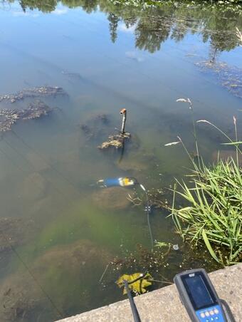
Installing a Piezometer near Bethany Lake
A piezometer is a device used to measure the pressure of a liquid, particularly water, within a specific point of a system, such as soil, rock, or a pipe. It is widely used in geotechnical, hydrogeological, and civil engineering applications to monitor water levels, pore water pressure, and hydraulic head in the ground or other systems.

Rock Creek
Rock Creek flows north to south in Washington County, Oregon and is a tributary of the Tualatin River.
Rock Creek flows north to south in Washington County, Oregon and is a tributary of the Tualatin River.

Bethany Lake weir
The concrete weir that impounds Bethany Lake was constructed in the 1950's to provide irrigation for Rock Creek Golf Course.
The concrete weir that impounds Bethany Lake was constructed in the 1950's to provide irrigation for Rock Creek Golf Course.
The USGS is studying Bethany Lake to provide a comprehensive picture of how the lake’s water conditions and nutrient sources tie into potential algae blooms.
Bethany Lake, located in Washington County, northwestern Oregon, is located within housing developments and is a popular recreational spot for activities such as hiking, birding, and fishing. Formed by a weir built in the 1950s, Bethany Lake receives inflow from Springville Creek and the surrounding area. Concerns are growing about the water quality in Bethany Lake due to Harmful Algal Blooms (HABs). These HABs, caused by certain cyanobacteria, can produce toxins harmful to humans, pets, and aquatic life. Factors like rising nutrient levels, urban runoff, and warming temperatures contribute to their increased occurrence.
Cyanotoxins not only pose health risks but also degrade water quality by depleting oxygen and impacting aquatic ecosystems. Bethany Lake’s connection to surrounding urban infrastructure, such as wastewater systems, adds complexity to understanding and mitigating these HABs.
Study Objectives
To address these challenges, the U.S. Geological Survey (USGS) and the cooperator are studying Bethany Lake with the following goals:
- Monitor water quality: Regularly measure factors like nutrient levels, algal species, and cyanotoxins to track algal bloom occurrences.
- Identify nutrient sources: Use advanced techniques, such as nitrogen isotope analysis, to pinpoint where excess nutrients are coming from—be it agricultural runoff, urban stormwater, or leaking wastewater systems.
- Support public health and management: Provide actionable insights into how water-quality parameters and nutrient sources relate to HABs.
Why This Matters
Bethany Lake exemplifies the challenges faced by urban water bodies across Oregon and the U.S., where agricultural and urban activities influence water quality. This study will:
- Enhance public safety: By identifying sources and conditions that lead to toxin production, the study aims to reduce health risks for the community and their pets.
- Inform policy and management: The findings will guide strategies to minimize nutrient loading and prevent future blooms.
- Expand scientific understanding: By exploring the interplay of hydrology, nutrient cycling, and urban infrastructure, the project contributes valuable insights driving the occurrence of HABs in mixed-use areas.
Media
Sources/Usage: Public Domain. View Media Details
Approach
A combination of continuous monitoring and periodic sampling will provide a comprehensive picture of the lake’s water quality:
- Sensors track water levels in Bethany Lake and Rock Creek, temperatures, and dissolved nutrients in real-time. Sensors are currently installed at four USGS gages in Bethany Lake and Rock Creek.
- Water samples are analyzed for cyanotoxins, algal species, and nutrient sources and concentrations to understand seasonal and spatial trends.
- Advanced tools, like isotopic analysis, will help link nutrient sources to algal growth.
The USGS will also test and refine methods to make monitoring more accessible for long-term public health applications.
Looking Ahead
By studying the intricate connections between nutrient sources, water conditions, and HABs, the project aims to determine a current baseline for Bethany Lake's water-quality. This information is vital for implementing effective management practices and safeguarding the health of residents, ecosystems, and wildlife. The outcomes of this study will also benefit other communities facing similar challenges, contributing to better water resource management nationwide.
Media
Sources/Usage: Public Domain. View Media Details
Photos from field work.
Installing a Piezometer near Bethany Lake
A piezometer is a device used to measure the pressure of a liquid, particularly water, within a specific point of a system, such as soil, rock, or a pipe. It is widely used in geotechnical, hydrogeological, and civil engineering applications to monitor water levels, pore water pressure, and hydraulic head in the ground or other systems.
A piezometer is a device used to measure the pressure of a liquid, particularly water, within a specific point of a system, such as soil, rock, or a pipe. It is widely used in geotechnical, hydrogeological, and civil engineering applications to monitor water levels, pore water pressure, and hydraulic head in the ground or other systems.
Rock Creek
Rock Creek flows north to south in Washington County, Oregon and is a tributary of the Tualatin River.
Rock Creek flows north to south in Washington County, Oregon and is a tributary of the Tualatin River.
Bethany Lake weir
The concrete weir that impounds Bethany Lake was constructed in the 1950's to provide irrigation for Rock Creek Golf Course.
The concrete weir that impounds Bethany Lake was constructed in the 1950's to provide irrigation for Rock Creek Golf Course.