
San Francisco Bay Basic Tide Model
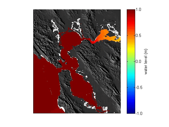
This web page provides files that may be used to run a basic depth-averaged (2DH) Deltares Delft3D version 4.00.01 astronomic tide model for San Francisco Bay. It was developed with the primary aim of assessing water level fluctuations and flow conditions in the vicinity of the Golden Gate (Elias and Hansen 2013).

San Francisco Bay is one of the most geographically expansive estuaries on the U.S. West Coast. The Bay supports the largest extent of tidal marsh in California yet is highly urbanized and impacted by numerous anthropogenic activities such as channel dredging, freshwater diversions, watershed modifications, urban run-off, ship traffic, exotic species introductions, and land reclamation (Barnard et al. 2013). The mixed semi-diurnal tide regime has a range of nearly 2 meters at the Golden Gate, the only inlet where ocean and estuarine water exchange occurs. Due in large part to bathymetric and geographic variations, water level variations and tidal flow patterns are complex. While many scientific studies and management questions are intrinsically linked to in-Bay tidal currents and water levels, they are often limited by the need for tools to assess tidal influences at specific study sites.
This web page provides a link to files that may be used to run a basic depth-averaged (2DH) Deltares Delft3D version 4.00.01 astronomic tide model for San Francisco Bay. It was developed with the primary aim of assessing water level fluctuations and flow conditions in the vicinity of the Golden Gate (Elias and Hansen 2013). The FLOW model consists of six 2-way coupled curvilinear domains; grid resolution varies and is finest in the vicinity of the Golden Gate where it is approximately 50m by 50m. Tides are simulated with amplitudes and phases of 12 locally dominant tidal constituents (M2, S2, N2, K2, K1, O1, P1, Q1, MF, MM, M4, MS4, and MN4) along the open ocean boundary. These files are provided ‘as is’ with the aim of promoting scientific advancement in the understanding of San Francisco Bay processes.
Citation
Elias, E., Hansen, J.E., and Erikson, L.H., 2013, San Francisco Bay basic tide model: U.S. Geological Survey data release, https://doi.org/10.5066/F7DN4330.
See Publications and Data and Tools tabs for references. Additional references:
- Barnard, P.L., Jaffe, B.E., Schoellhamer, D.H., 2013. Preface for Special Issue of Marine Geology. Marine Geology Special Issue on Sediment Transport and Geomorphic Evolution in the San Francisco Bay Coastal System, 345, 1-2. doi: 10.1016/j.margeo.2013.09.010
- NOAA National Geophysical Data Center, U.S. Coastal Relief Model
Disclaimer
This information is subject to revision. It is being provided to meet the need for timely best science. The information is provided on the condition that neither the U.S. Geological Survey nor the U.S. Government may be held liable for any damages resulting from the authorized or unauthorized use of the information.
This web page provides files that may be used to run a basic depth-averaged (2DH) Deltares Delft3D version 4.00.01 astronomic tide model for San Francisco Bay. It was developed with the primary aim of assessing water level fluctuations and flow conditions in the vicinity of the Golden Gate (Elias and Hansen 2013).
San Francisco Bay is one of the most geographically expansive estuaries on the U.S. West Coast. The Bay supports the largest extent of tidal marsh in California yet is highly urbanized and impacted by numerous anthropogenic activities such as channel dredging, freshwater diversions, watershed modifications, urban run-off, ship traffic, exotic species introductions, and land reclamation (Barnard et al. 2013). The mixed semi-diurnal tide regime has a range of nearly 2 meters at the Golden Gate, the only inlet where ocean and estuarine water exchange occurs. Due in large part to bathymetric and geographic variations, water level variations and tidal flow patterns are complex. While many scientific studies and management questions are intrinsically linked to in-Bay tidal currents and water levels, they are often limited by the need for tools to assess tidal influences at specific study sites.
This web page provides a link to files that may be used to run a basic depth-averaged (2DH) Deltares Delft3D version 4.00.01 astronomic tide model for San Francisco Bay. It was developed with the primary aim of assessing water level fluctuations and flow conditions in the vicinity of the Golden Gate (Elias and Hansen 2013). The FLOW model consists of six 2-way coupled curvilinear domains; grid resolution varies and is finest in the vicinity of the Golden Gate where it is approximately 50m by 50m. Tides are simulated with amplitudes and phases of 12 locally dominant tidal constituents (M2, S2, N2, K2, K1, O1, P1, Q1, MF, MM, M4, MS4, and MN4) along the open ocean boundary. These files are provided ‘as is’ with the aim of promoting scientific advancement in the understanding of San Francisco Bay processes.
Citation
Elias, E., Hansen, J.E., and Erikson, L.H., 2013, San Francisco Bay basic tide model: U.S. Geological Survey data release, https://doi.org/10.5066/F7DN4330.
See Publications and Data and Tools tabs for references. Additional references:
- Barnard, P.L., Jaffe, B.E., Schoellhamer, D.H., 2013. Preface for Special Issue of Marine Geology. Marine Geology Special Issue on Sediment Transport and Geomorphic Evolution in the San Francisco Bay Coastal System, 345, 1-2. doi: 10.1016/j.margeo.2013.09.010
- NOAA National Geophysical Data Center, U.S. Coastal Relief Model
Disclaimer
This information is subject to revision. It is being provided to meet the need for timely best science. The information is provided on the condition that neither the U.S. Geological Survey nor the U.S. Government may be held liable for any damages resulting from the authorized or unauthorized use of the information.