
USGS Research Oceanographer Li Erikson collects coastal data along the Pacific coast during her Mendenhall Fellowship. Her research is focused on coastal storm modeling, storm-induced coastal flooding, erosion, and cliff failures over large geographic scales.
Li Erikson
Research Oceanographer at the USGS Pacific Coastal and Marine Science Center
Science and Products
Filter Total Items: 22
Typhoon Merbok Disaster Recovery Project: Accomplishments
Supported by Title VII of Division N of the Consolidated Appropriations Act, 2023, the Typhoon Merbok Disaster Emergency Recovery Efforts project addresses critical data and capacity gaps in coastal Alaska by generating high resolution environmental datasets, hazard analyses, and monitoring tools needed to quantify erosion, flooding, and permafrost-related risks at the community scale.

Alaska Flood Staffs
The U.S. Geological Survey (USGS) uses observations of flooding in communities to monitor hazard conditions and support research by the USGS and its partners into a variety of hazard processes in Alaska. Local observations of flooding at flood staffs are used to document flood elevations, improve flood models, and support floodplain management decisions.

Typhoon Merbok Disaster Emergency Recovery Efforts
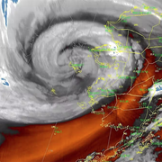
Extreme storm events, such as Extratropical-Typhoon Merbok that hit the coast of Western Alaska in September 2022, are stark reminders of the devastating impacts coastal storms can have on Alaska Native community’s livelihoods and infrastructure. A chronic lack of environmental monitoring and technical assistance in rural Alaska present major barriers to communities affected by Typhoon Merbok...

Coastal Climate Impacts
The impacts of climate change and sea-level rise around the Pacific and Arctic Oceans can vary tremendously. Thus far the vast majority of national and international impact assessments and models of coastal climate change have focused on low-relief coastlines that are not near seismically active zones. Furthermore, the degree to which extreme waves and wind will add further stress to coastal...

Dynamic coastlines along the western U.S.
The west coast of the United States is extremely complex and changeable because of tectonic activity, mountain building, and land subsidence. These active environments pose a major challenge for accurately assessing climate change impacts, since models were historically developed for more passive sandy coasts.

The Impact of Sea-Level Rise and Climate Change on Pacific Ocean Atolls
Providing basic understanding and specific information on storm-wave inundation of atoll islands that house Department of Defense installations, and assessing the resulting impact of sea-level rise and storm-wave inundation on infrastructure and freshwater availability under a variety of sea-level rise and climatic scenarios.

Climate impacts to Arctic coasts
The Arctic region is warming faster than anywhere else in the nation. Understanding the rates and causes of coastal change in Alaska is needed to identify and mitigate hazards that might affect people and animals that call Alaska home.

Building a Coastal Flood Hazard Assessment and Adaptation Strategy with At-Risk Communities of Alaska
Coastal flooding and erosion caused by storms and sea-level rise threaten infrastructure and public safety in Alaska Native communities. Though the problem is well known, there are few tools that can assess local vulnerability to coastal flood hazards. Even fewer tools can be customized with specific community information to support local adaptation planning. The main goal of this...

Coastal Storm Modeling System (CoSMoS)
The Coastal Storm Modeling System (CoSMoS) makes detailed predictions of storm-induced coastal flooding, erosion, and cliff failures over large geographic scales. CoSMoS was developed for hindcast studies, operational applications and future climate scenarios to provide emergency responders and coastal planners with critical storm-hazards information that can be used to increase public safety...

Using Video Imagery to Study Wave Dynamics: Unalakleet
USGS scientists installed two video cameras atop a windmill tower in Unalakleet, Alaska, pointing westward over Norton Sound, to observe and quantify coastal processes such as wave run-up, development of rip channels, bluff erosion, and movement of sandbars and ice floes.

Using Video Imagery to Study Sediment Transport and Wave Dynamics: Nuvuk (Point Barrow)
Two coastal observing video cameras were installed atop a utility pole near the northernmost point of land in the United States, at Nuvuk (Point Barrow), Alaska. The cameras pointed northwest toward the Arctic Ocean and the boundary between the Chukchi and Beaufort Seas, and were used to observe and quantify coastal processes such as wave run-up, bluff erosion, movement of sandbars and ice floes...

CoSMoS 3.1: Central California
CoSMoS v3.1 for central California shows projections for future climate scenarios (sea-level rise and storms)

Li Erikson
USGS Research Oceanographer Li Erikson collects coastal data along the Pacific coast during her Mendenhall Fellowship. Her research is focused on coastal storm modeling, storm-induced coastal flooding, erosion, and cliff failures over large geographic scales.
Science and Products
Filter Total Items: 22
Typhoon Merbok Disaster Recovery Project: Accomplishments
Supported by Title VII of Division N of the Consolidated Appropriations Act, 2023, the Typhoon Merbok Disaster Emergency Recovery Efforts project addresses critical data and capacity gaps in coastal Alaska by generating high resolution environmental datasets, hazard analyses, and monitoring tools needed to quantify erosion, flooding, and permafrost-related risks at the community scale.
Alaska Flood Staffs
The U.S. Geological Survey (USGS) uses observations of flooding in communities to monitor hazard conditions and support research by the USGS and its partners into a variety of hazard processes in Alaska. Local observations of flooding at flood staffs are used to document flood elevations, improve flood models, and support floodplain management decisions.
Typhoon Merbok Disaster Emergency Recovery Efforts
Extreme storm events, such as Extratropical-Typhoon Merbok that hit the coast of Western Alaska in September 2022, are stark reminders of the devastating impacts coastal storms can have on Alaska Native community’s livelihoods and infrastructure. A chronic lack of environmental monitoring and technical assistance in rural Alaska present major barriers to communities affected by Typhoon Merbok...
Coastal Climate Impacts
The impacts of climate change and sea-level rise around the Pacific and Arctic Oceans can vary tremendously. Thus far the vast majority of national and international impact assessments and models of coastal climate change have focused on low-relief coastlines that are not near seismically active zones. Furthermore, the degree to which extreme waves and wind will add further stress to coastal...
Dynamic coastlines along the western U.S.
The west coast of the United States is extremely complex and changeable because of tectonic activity, mountain building, and land subsidence. These active environments pose a major challenge for accurately assessing climate change impacts, since models were historically developed for more passive sandy coasts.
The Impact of Sea-Level Rise and Climate Change on Pacific Ocean Atolls
Providing basic understanding and specific information on storm-wave inundation of atoll islands that house Department of Defense installations, and assessing the resulting impact of sea-level rise and storm-wave inundation on infrastructure and freshwater availability under a variety of sea-level rise and climatic scenarios.
Climate impacts to Arctic coasts
The Arctic region is warming faster than anywhere else in the nation. Understanding the rates and causes of coastal change in Alaska is needed to identify and mitigate hazards that might affect people and animals that call Alaska home.
Building a Coastal Flood Hazard Assessment and Adaptation Strategy with At-Risk Communities of Alaska
Coastal flooding and erosion caused by storms and sea-level rise threaten infrastructure and public safety in Alaska Native communities. Though the problem is well known, there are few tools that can assess local vulnerability to coastal flood hazards. Even fewer tools can be customized with specific community information to support local adaptation planning. The main goal of this...
Coastal Storm Modeling System (CoSMoS)
The Coastal Storm Modeling System (CoSMoS) makes detailed predictions of storm-induced coastal flooding, erosion, and cliff failures over large geographic scales. CoSMoS was developed for hindcast studies, operational applications and future climate scenarios to provide emergency responders and coastal planners with critical storm-hazards information that can be used to increase public safety...
Using Video Imagery to Study Wave Dynamics: Unalakleet
USGS scientists installed two video cameras atop a windmill tower in Unalakleet, Alaska, pointing westward over Norton Sound, to observe and quantify coastal processes such as wave run-up, development of rip channels, bluff erosion, and movement of sandbars and ice floes.
Using Video Imagery to Study Sediment Transport and Wave Dynamics: Nuvuk (Point Barrow)
Two coastal observing video cameras were installed atop a utility pole near the northernmost point of land in the United States, at Nuvuk (Point Barrow), Alaska. The cameras pointed northwest toward the Arctic Ocean and the boundary between the Chukchi and Beaufort Seas, and were used to observe and quantify coastal processes such as wave run-up, bluff erosion, movement of sandbars and ice floes...
CoSMoS 3.1: Central California
CoSMoS v3.1 for central California shows projections for future climate scenarios (sea-level rise and storms)
Li Erikson
USGS Research Oceanographer Li Erikson collects coastal data along the Pacific coast during her Mendenhall Fellowship. Her research is focused on coastal storm modeling, storm-induced coastal flooding, erosion, and cliff failures over large geographic scales.
USGS Research Oceanographer Li Erikson collects coastal data along the Pacific coast during her Mendenhall Fellowship. Her research is focused on coastal storm modeling, storm-induced coastal flooding, erosion, and cliff failures over large geographic scales.