
Groundwater/Surface Water Interaction near Ellerbe Creek, Durham, NC
Falls Lake has been included in the North Carolina Division of Water Quality’s 303(d) list of “impaired” waters, due to violations of the State chlorophyll-a standard caused by excessive nutrient inputs (North Carolina Department of Environment and Natural Resources, Division of Water Quality, 2010a). The North Carolina Environmental Management Commission has adopted nutrient management strategies for the reservoir that call for comprehensive controls to reduce nitrogen and phosphorus loads from significant sources in the watershed, including urban stormwater, wastewater, and agriculture (North Carolina Department of Environment and Natural Resources, Division of Water Quality, 2010b-d).
Ellerbe Creek, a tributary to Falls Lake, has elevated concentrations of nutrients, initially attributed to the presence of the North Durham Water Reclamation Facility (NDWRF). Engineering upgrades have been completed on the plant processing infrastructure, yet elevated nutrient levels in Ellerbe Creek persist.
Approach: The objective of this study is to collect surface-water flow, water temperature, and water-quality data to clarify the relation between groundwater and surface water in the area downstream of the NDWRF and adjacent to a closed municipal landfill. Results will provide an analysis of the potential nutrient inputs from groundwater adjacent to the landfill and for optimizing the installation locations of nutrient-reduction best management practices in the study area. The paragraphs below describe project tasks.
Conducted a reconnaissance survey and collected water-quality samples
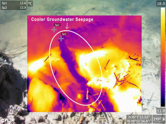
A reconnaissance survey of Ellerbe Creek identified potential areas of groundwater discharge. Handheld Forward-Looking Infrared Radiometer (FLIR) cameras were utilized, as well as long probe thermistors. The FLIR cameras allowed high resolution image capture of real-time variations in water temperature. This information helped to identify areas of groundwater discharge and optimize water-quality monitoring/sampling locations. The reconnaissance survey located potential areas of groundwater seepage, samples were collected at the point of groundwater discharge. Water samples were analyzed for nutrients and major ions by the USGS National Water Quality Laboratory.
- Media
 Sources/Usage: Public Domain. View Media Details
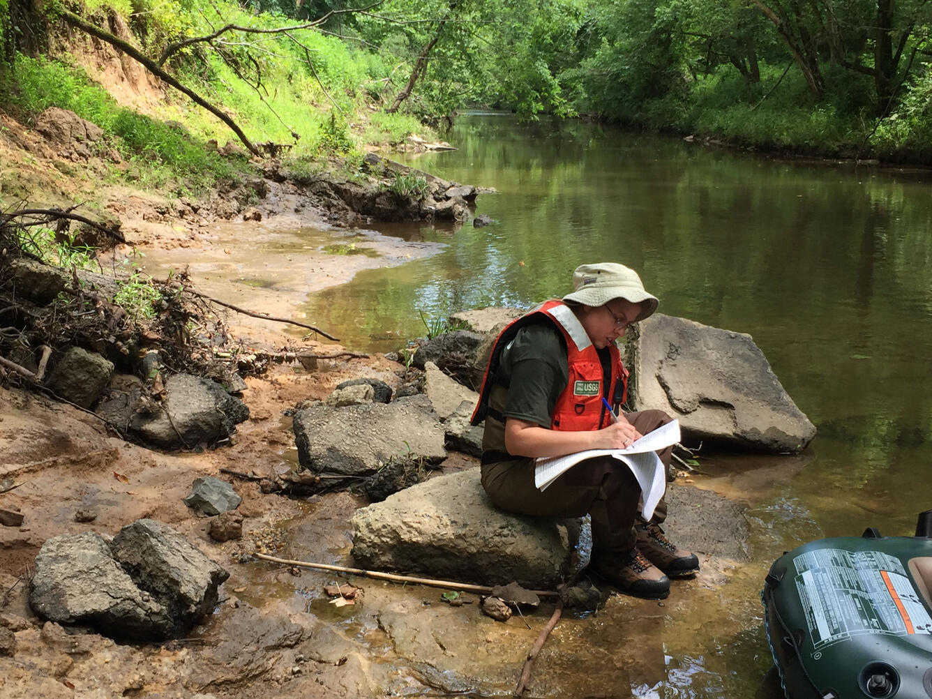
USGS Scientist Installing Temperature Sensor Rods in Ellerbe Creek(Public domain.) Measure groundwater seepage
During the reconnaissance, locations for stream flow measurements for seepage (using acoustic Doppler velocimeters) were determined based upon likely areas of groundwater discharge using thermal imaging results. Standard USGS methodologies (Rantz, 1982 and Turnipseed and Sauer, 2010) were used to measure and report streamflow at each discharge measurement location. Increase in stream discharge along each segment of the reach, not associated with small stream inflows, were attributed to groundwater contributions. Measure groundwater flux
Within Ellerbe Creek, temperatures were monitored with a fiber optic distributed temperature system (FO-DTS). Temperature measurements were used as a passive tracer to locate areas of groundwater discharge. The FO-DTS was deployed longitudinally over 1,000 feet and recorded temperature every 15 minutes at approximately 3-foot intervals. The FO-DTS was deployed for 7 days to continually collect data over 6 full diurnal cycles. Previous USGS investigations (Lowry and others, 2007) have shown that the FO-DTS is an ideal instrument to monitor stream temperature spatial variability. The FO-DTS survey located areas of groundwater seepage that were not identified using the FLIR camera, similar screening water-quality samples were collected. Areas of groundwater discharge located during the FO-DTS study will be modeled using a 1-dimensional heat-transport model to simulate groundwater discharge.
Falls Lake has been included in the North Carolina Division of Water Quality’s 303(d) list of “impaired” waters, due to violations of the State chlorophyll-a standard caused by excessive nutrient inputs (North Carolina Department of Environment and Natural Resources, Division of Water Quality, 2010a). The North Carolina Environmental Management Commission has adopted nutrient management strategies for the reservoir that call for comprehensive controls to reduce nitrogen and phosphorus loads from significant sources in the watershed, including urban stormwater, wastewater, and agriculture (North Carolina Department of Environment and Natural Resources, Division of Water Quality, 2010b-d).
Ellerbe Creek, a tributary to Falls Lake, has elevated concentrations of nutrients, initially attributed to the presence of the North Durham Water Reclamation Facility (NDWRF). Engineering upgrades have been completed on the plant processing infrastructure, yet elevated nutrient levels in Ellerbe Creek persist.
Approach: The objective of this study is to collect surface-water flow, water temperature, and water-quality data to clarify the relation between groundwater and surface water in the area downstream of the NDWRF and adjacent to a closed municipal landfill. Results will provide an analysis of the potential nutrient inputs from groundwater adjacent to the landfill and for optimizing the installation locations of nutrient-reduction best management practices in the study area. The paragraphs below describe project tasks.
Conducted a reconnaissance survey and collected water-quality samples
A reconnaissance survey of Ellerbe Creek identified potential areas of groundwater discharge. Handheld Forward-Looking Infrared Radiometer (FLIR) cameras were utilized, as well as long probe thermistors. The FLIR cameras allowed high resolution image capture of real-time variations in water temperature. This information helped to identify areas of groundwater discharge and optimize water-quality monitoring/sampling locations. The reconnaissance survey located potential areas of groundwater seepage, samples were collected at the point of groundwater discharge. Water samples were analyzed for nutrients and major ions by the USGS National Water Quality Laboratory.
- Media
Sources/Usage: Public Domain. View Media Details
USGS Scientist Installing Temperature Sensor Rods in Ellerbe Creek(Public domain.) Measure groundwater seepage
During the reconnaissance, locations for stream flow measurements for seepage (using acoustic Doppler velocimeters) were determined based upon likely areas of groundwater discharge using thermal imaging results. Standard USGS methodologies (Rantz, 1982 and Turnipseed and Sauer, 2010) were used to measure and report streamflow at each discharge measurement location. Increase in stream discharge along each segment of the reach, not associated with small stream inflows, were attributed to groundwater contributions. Measure groundwater flux
Within Ellerbe Creek, temperatures were monitored with a fiber optic distributed temperature system (FO-DTS). Temperature measurements were used as a passive tracer to locate areas of groundwater discharge. The FO-DTS was deployed longitudinally over 1,000 feet and recorded temperature every 15 minutes at approximately 3-foot intervals. The FO-DTS was deployed for 7 days to continually collect data over 6 full diurnal cycles. Previous USGS investigations (Lowry and others, 2007) have shown that the FO-DTS is an ideal instrument to monitor stream temperature spatial variability. The FO-DTS survey located areas of groundwater seepage that were not identified using the FLIR camera, similar screening water-quality samples were collected. Areas of groundwater discharge located during the FO-DTS study will be modeled using a 1-dimensional heat-transport model to simulate groundwater discharge.