
Update for the South Carolina Atlantic Coastal Plain Groundwater Availability Model
Groundwater use from the Atlantic Coastal Plain aquifers in South Carolina has increased during the past 70 years as the population has increased along with demands for municipal, industrial, and agricultural water needs. While South Carolina works to increase development of water supplies in response to the rapid population growth, the State is facing a number of unanswered questions regarding availability of groundwater supplies and the best methods to manage these important supplies.
The objective of the proposed investigation is to update the groundwater flow model of the South Carolina Coastal Plain presented in Campbell and Coes, 2010.
Background

The Atlantic Coastal Plain aquifers and confining units of South Carolina are composed of crystalline carbonate rocks, sand, clay, silt, and gravel and contain large volumes of high-quality groundwater (fig. 1). The aquifers have a long history of use dating back to the earliest days of European settlement in the late 1600s. Although extensive areas of some of the aquifers have or currently (2015) are experiencing groundwater level declines from large-scale, concentrated pumping centers, large areas of the South Carolina (SC) Atlantic Coastal Plain contain substantial quantities of high-quality groundwater that currently (2015) are unused.
Groundwater use from the Atlantic Coastal Plain aquifers in South Carolina has increased during the past 70 years as the population has increased along with demands for municipal, industrial, and agricultural water needs. While South Carolina works to increase development of water supplies in response to the rapid population growth, the State is facing a number of unanswered questions regarding availability of groundwater supplies and the best methods to manage these important supplies.
An in-depth assessment of groundwater availability of the Atlantic Coastal Plain aquifers of North and South Carolina was completed in 2008 by the U.S. Geological Survey (USGS) (Campbell and Coes, 2010), the South Carolina Department of Natural Resources (SCDNR), and the North Carolina Division of Water Resources (DWR). This assessment includes (1) a determination of the status (2004) of the Atlantic Coastal Plain groundwater resources; (2) an explanation for how these resources have changed over time; and (3) development of tools to assess the system’s response to stresses from potential future climate variability.
The primary products of this effort were (1) comprehensive hydrologic datasets such as groundwater levels, groundwater use, and aquifer properties; (2) a revised hydrogeologic framework; (3) simulated water budgets of the overall study area along with several subareas; and (4) construction and calibration of a numerical modeling tool that is used to forecast the potential effects of climate change on groundwater levels. However, there has been a significant amount of new data collected since 2004 such as groundwater levels from an expanded monitoring network, water-use data, and new hydrogeologic framework interpretations.
A three-dimensional finite-difference numerical code (MODFLOW-2000) was used to simulate groundwater flow within the aquifers and confining units of the Coastal Plain of North and SC and parts of Georgia and Virginia. The approximately 70,500-square-mile (mi2) study area was represented in the model by a grid of 130 rows and 275 columns made up of 4-square-mile cells. The hydrogeologic system of alternating layers of permeable sand or crystalline carbonate rocks separated by confining units of silt, clay, or low-permeability crystalline carbonate rocks was represented by 16 deformed grid model layers. The flow simulation began with a steady-state stress period representing predevelopment flow conditions prior to 1900 and concluded with transient stress periods representing subsequent pumping and variable recharge through 2004. The model was calibrated to conditions representing the three flow systems of pre-1900, 1980-82, and 2004.
Groundwater use data has been collected in SC since 1983 (S.C. Department of Health and Environmental Control, 2006) (fig. 2A, 2B). Groundwater use in the SC Coastal Plain counties has increased from about 97 million gallons per day (Mgal/d) in 1982 to a high in 2002 of 223 Mgal/d. In 2013, the latest year that data is available, groundwater use was about 197 Mgal/d.
PROBLEM
—————————————————————————————————————————————————————

The Campbell and Coes (2010) model was calibrated to 2004 conditions, which are now over 10 years old and during that time there have been many changes in groundwater withdrawal patterns and use in the SC Coastal Plain. An example of these changes is the difference in the groundwater levels from 2004 to 2011, in the Middendorf aquifer, one of the primary water-supply units in the SC Coastal Plain. The best illustration of these changing groundwater level patterns compares groundwater level maps of the primary water-supply aquifers in the SC Coastal Plain that are regularly produced by SCDNR. The potentiometric surface (groundwater level surface) maps (Hockensmith, 2008a and Hockensmith and others, 2013a) show changing patterns of groundwater use in several of the primary aquifers. An example is in the Hemingway, SC (Williamsburg County) area where a small depression in the groundwater levels was observed in 2004. By 2011, this depression had grown to a much larger extent to the west and northwest. Additionally, the groundwater levels and water use had changed from 2004 to 2011 within the Middendorf aquifer in the Charleston and Berkeley County area. In the Black Creek aquifer, the depression in groundwater levels in Georgetown County deepened from 2004 to 2012 (Hockensmith, 2008b and Hockensmith and others, 2013b). However, small depressions in the Black Creek aquifer groundwater levels in Florence and Sumter Counties that were mapped in 2004 had recovered in 2012. These changing patterns of groundwater use and groundwater levels present management challenges to water users and managers. One way to assist water managers and users is to have a comprehensive tool, such as an up-to-date groundwater flow model that can be used to simulate the changing groundwater conditions and to provide insight into various potential management strategies.

The SCDNR, S.C. Department of Health and Environmental Control (SCDHEC) and USGS maintain equipment in wells around the SC Coastal Plain that continuously record groundwater levels on an hourly basis in the primary water-supply aquifers. Data collected at these wells from 2004 to 2015 show changing groundwater-use patterns across the SC Coastal Plain (Harder and others, 2012; US Geological Survey Groundwater Watch, 2015). Some examples of the changes are in Aiken County, where groundwater levels in the Black Creek and Middendorf aquifers have declined 3-10 feet (ft) since the mid 1990’s. A Black Creek aquifer well in Marion County has shown a steady decline of about about 40 ft from 1985 to 2015.
Overall, groundwater use in the SC Coastal Plain from 2004-2013 has increased slightly from about 202 million gallons per day (Mgal/d) in 2004 to an average of 209 Mgal/d from 2005 to 2013 (SCDHEC, written commun, 2015) (fig. 2A). There has been a significant increase in irrigated agriculture in SC, with much of this new water demand met by groundwater use (fig. 2B). In SC this trend is likely to continue. Potential adverse effects of the continued increase in groundwater withdrawals include groundwater level declines and reduced baseflow to streams and other surface-water bodies.
The population of SC has increased substantially from 2000 to 2014 growing from about 4.0 to about 4.6 million residents (U.S. Census Bueau, 2015). The 13-percent increase in population is not evenly distributed across the state but tends to be concentrated in the larger cities and coastal areas. Some of the water needs for this growing population are being met by groundwater use which tends to be concentrated public supply use in a few muncipalities in the SC Coastal Plain (fig. 3).
The SC Agriculture Commission is actively recruiting industrial-scale farms to locate in the Coastal Plain counties of SC (SC Commissioner of Agriculture, oral commun., March 2015) (fig. 4). These new farms will most likely use groundwater for their primary source of irrigation water and are likely to be clustered in areas with suitable soils, transportation, and labor. In addition, the Palmetto Agribusiness Council has a plan to increase the economic impact of agriculture, forestry, and allied industries from \$34 billion to \$50 billion by 2020 (Palmetto Agribusiness Council, 2015). This new agricultural activity will demand large quantities of water that will most likely be supplied primarily by groundwater. It is not known if these proposed increases in groundwater use for agricultural uses will have negative effects on groundwater levels, surface-water flows and/or other groundwater users.
Precipitation patterns are changing across the SC Coastal Plain with implications for groundwater recharge rates. Reduced precipitation rates, especially in the cooler months (November – March) could lead to lower groundwater recharge rates and groundwater levels. A study by Mizzell and others (2014) of historic precipitation trends, indicates a general decrease in precipitation in SC from 1900 to 2010 for summer rainfalls, increasing fall precipitation, and mixed increases and decreases for winter and spring. Future precipitation patterns could follow these trends.

The South Carolina Water Plan, 2nd Edition (Badr and others, 2004) states: “A comprehensive groundwater flow model of the Coastal Plain should be developed and used to predict the effects of future pumping and to determine optimal well spacings”. The proposed update to the Campbell and Coes (2010) model will provide the model described in the SC Water Plan. An updated groundwater flow model of the South Carolina Coastal Plain will benefit the State of SC by providing a tool that can be used by water-resource managers to estimate current available water resources and to assess the effects of future water use development and climate variability on available water resources. The USGS proposes to work cooperatively with the SCDNR, SCDHEC, and SC Department of Agriculture to develop an updated groundwater flow model of the South Carolina Coastal Plain.
OBJECTIVES AND SCOPE
—————————————————————————————————————————————————————
The objective of the proposed investigation is to update the groundwater flow model of the South Carolina Coastal Plain presented in Campbell and Coes, 2010. Updates to the model will include activating and rediscretizing the surficial aquifer model layer, adding recent groundwater-related data (2005-2015), refining the model grid in some areas, incorporating a more detailed representation of the Fall Line area, re-calibration, and applying the model to a series of 6 scenarios. Numerous sites have been added to the SC groundwater level monitoring network, primarily by the SCDNR and SCDHEC, since 2004 when the Campbell and Coes (2010) model was last calibrated (Harder and others, 2014; H. Gilkerson, SCDHEC, personal commun., 2015). Water-use data have been compiled by SCDHEC for 2005-2014 and will be simulated in the proposed groundwater model update. A series of 6 future scenarios will be simulated with the updated model to attempt to give some insight into how potential changes in groundwater withdrawal patterns and rates and climatic changes could affect groundwater levels and stream baseflows.
The scope of this investigation will include the South Carolina Atlantic Coastal Plain aquifers and confining units. However, to simulate model boundary conditions, the model is extended into the Georgia and North Carolina Coastal Plain. A USGS Scientific Investigations report documenting the investigation will be published during the final year of the study.
APPROACH
—————————————————————————————————————————————————————
The objectives listed above will be met during this 3-year investigation by implementation of the following 6 tasks.
Task 1: Data Acquistion
- Compile existing hydrostratigraphic data: This task will include compiling all data necessary to update the regional hydrogeologic framework at a finer scale, especially in the surficial aquifer layer of the model. Existing geologic reports and maps, subsurface data and hydrogeologic information will be assembled to refine the current hydrostratigraphy presented in Gellici and Lautier (2010). Project personnel will work closely with state agency scientists who have extensive knowledge of the proposed study area.
- Compile and interpret existing aquifer-test data: Aquifer-test data are available from several sources in the study area. Recent data from the USGS and state agencies will be collected, interpreted, and input into the model.
- Compile existing groundwater-level data: There are several sources of groundwater-level data in the study area. Existing reports, the USGS database, and SCDNR and SCDHEC will be the primary sources of historic and recent groundwater-level data collected in the area.
- Refine the existing regional hydrogeologic framework to incorporate recent data: The current hydrogeologic framework for the proposed study area will be refined, where needed, by using currently available stratigraphic and hydrogeologic data. The refined framework will use existing wells that have the required data available (geophysical logs, cores, and drill cuttings descriptions). The Fall Line area of the model will be updated to a 1:500,000 scale that is available from the SCDNR (S.C. Department of Natural Resources, 2015)
- Collect and compile water-use data: Groundwater use data from 2005 to Year 1 of the study will be acquired from SCDHEC.
Task 2: Convert Data to Various Model Inputs
- The various types of data (water use, groundwater levels, stream baseflows, perennial stream location and stage/bottom elevations, and hydrogeologic framework) will be formatted for input into the groundwater flow model. This task will be accomplished primarily with the use of geographic information system software, database software and spreadsheets. These data will be input into the graphical-use interface software for use in the groundwater flow model. These data will be archived for future use.
Task 3: Re-Configure Groundwater Flow Model
- Updating the existing groundwater flow model is a challenging and difficult task. The area simulated is very large (~70,000 mi2, with about 22,500 mi2 in SC) and contains 16 aquifers and confining units. At the time the original model was being constructed and calibrated (2004-2008), the model strained the hardware and software resources and was difficult to construct and calibrate due to large file sizes and long run times. Since then, computing resources are much improved, primarily with the 64-bit computers and software currently available. However, attempting to simulate such a large area and number of aquifers is still challenging and reducing the model cell size and increasing the number of simulated streams, rivers, and surface water bodies is anticipated to again strain the computing resources available. Attempts will be made to simulate the natural system in detail, but most likely, trade-offs will have to made to simplify the simulations and some hydrologic features (such as stream networks) will have to be reduced in detail. These decisions will be made in consultation with SCDNR Hydrologists. A recent USGS groundwater study in the Chesterfield County area (Campbell and Landmeyer, 2014) was able to produce a MODFLOW groundwater flow model with 300 x 300 ft model cells that adequately simulated groundwater – surface water interactions. This level of detail was able to use the surface-water features on a 1:24,000 scale. This 1:24,000 scale will be the first level of detail attempted with the model update but may have to be simplified to some extent to overcome computing limitations.
- The existing groundwater-flow model of the North Carolina–South Carolina Atlantic Coastal Plain (Campbell and Coes, 2010) will be updated using MODFLOW-2005 (Harbaugh, 2005), or possibly a new version of MODFLOW, MODFLOW-2015 that is under development (C. Langevin, USGS, oral commun., 2014). One of the primary modifications to the Campbell and Coes (2010) model will activate the entire surficial aquifer layer and decrease the grid-spacing of 2 x 2 miles. The new surficial aquifer grid spacing will be determined as the model construction proceeds and will be limited by available computer software and hardware resources. In addition, other model layers grid spacing may be reduced if sufficient data, such as groundwater use or groundwater levels are available for specific areas. A commercial graphical user interface will be used to enhance pre- and post-processing tasks, as well as to allow for visualization, ease of use, and updating. This modeling effort will include all of the Atlantic Coastal Plain aquifers in the study area. Boundary conditions from the Campbell and Coes (2010) model will initially be used and but may be modified to best simulate natural groundwater flow and surface-water –groundwater interaction conditions within the aquifers.
- The Campbell and Coes (2010) groundwater flow model will be modified in several important ways with new simulation capabilities. A new version of the USGS Modular Model (MODFLOW-2005), MODFLOW-NWT or MODFLOW Newton will be used in place of the original MODFLOW Layer Property Flow package. MODFLOW-NWT is a Newton-Raphson formulation for MODFLOW-2005 to improve solution of unconfined groundwater-flow problems. MODFLOW-NWT is intended for solving problems involving drying and rewetting nonlinearities of the unconfined groundwater-flow equation (Niswonger and others, 2011). The USGS MODFLOW Unstructured Grid (USG) package (Panday and others, 2013) will be used to allow a varying size model grid in the surficial model layer and possibly in other model layers. The varying model grid size will attempt to better simulate groundwater – surface water interactions within the surficial layer of the model. The Campbell and Coes (2010) model simulated only the major rivers such as the Savannah, North and South Edisto, and the Pee Dee Rivers in the inner Coastal Plain. The updated model will attempt to activate the entire surficial aquifer model layer and simulate smaller streams along with the major rivers in both the inner and outer Coastal Plain. The outer Coastal Plain surficial aquifer was simulated with specified heads in the Campbell and Coes (2010) model. These outer Coastal Plain areas will be converted to smaller, active model cells (instead of the original specified-head type cells) that will attempt to simulate groundwater – surface interactions of smaller streams.
- The boundary conditions from the Campbell and Coes (2010) model will be re-evaluated and modified as appropriate to best represent the natural hydrologic conditions. Stream networks will be included in the model in the surficial aquifer at a scale that is allowed by the computer resources. The updated groundwater-flow model will extend to natural hydrologic boundaries, such as the Fall Line to the north, the Altamaha River to the west, the James River to the east and the offshore extent of the aquifer to the southeast, to properly simulate groundwater flow. Climatic water budgets will be applied to better estimate net recharge (precipitation minus evapotranspiration minus surface runoff). The estimated net recharge may be refined during the recalibration process.
- The original downgradient (seaward) model boundaries were simulated as no-flow boundaries and there was no variable density component to these boundary conditions. The updated model will use a new MODFLOW package, the Seawater Intrusion 2 (SWI2) package (Bakker and others, 2013) that allows three-dimensional vertically integrated variable-density groundwater flow and seawater intrusion in coastal multi-aquifer systems to be simulated using MODFLOW-2005. Use of the SWI2 package will allow a more realistic simulation of the seaward aquifer boundaries than the original Campbell and Coes (2010) model.
Task 4: Re-Calibrate Model to Past and Current (Year 1) Conditions
- The groundwater flow model will be re-calibrated to the following conditions 1) predevelopment, 2) 1982, 3) 2004, and 4) Year 1 of the proposed project. The model will be calibrated with an automated parameter-estimation approach using the computer program PEST (Doherty, 2005). The objective of the calibration process is to minimize the weighted sum-of-squares differences between model-generated groundwater-level values and stream baseflows and field-measured groundwater-levels and stream baseflows. Recent (2013) groundwater age dates collected from a series of Cretaceous-age aquifer public-supply wells by the USGS National Water Quality Program will be used in the model calibration process.
Task 5: Scenarios
- A series of six scenarios will be programmed with the updated and calibrated groundwater flow model. These scenarios will be planned with the various State Agency Cooperators and designed to provide information on the possible effects of changing patterns of groundwater use and (or) changes in future precipitation rates and the subsequent effects on the groundwater levels and stream baseflows of the SC Coastal Plain.
Task 6: Report Preparation
- The updated groundwater flow model will be documented in a USGS Scientific Investigations Report (SIR) that will include all of the required descriptions of the model inputs, outputs, and scenarios along with a model archive.
Report
A USGS SIR will be published to document the updated groundwater flow model and summarize the results of the scenarios. The SIR will not have to be as detailed as the original model documentation report (Campbell and Coes, 2010) since it will describe an update to the original model.
REFERENCES
—————————————————————————————————————————————————————
Badr, A. W., Wachob, A., and Gellici, J. A., 2004, South Carolina Water Plan, 2nd Edition: South Carolina Department of Natural Resources, Land, Water and Conservation Division, 120p.
Bakker, Mark, Schaars, Frans, Hughes, J.D., Langevin, C.D., and Dausman, A.M., 2013, Documentation of the Seawater Intrusion (SWI2) Package for MODFLOW: U.S. Geological Survey Techniques and Methods, book 6, chap. A46, 47 p.,
Campbell, B.G., and Coes, A.L., eds., 2010, Groundwater availability in the Atlantic Coastal Plain of North and South Carolina: U.S. Geological Survey Professional Paper 1773, 241 p., 7 pls.
Campbell, B.G., and Landmeyer, J.E., 2014, Groundwater availability in the Crouch Branch and McQueen Branch aquifers, Chesterfield County, South Carolina, 1900–2012: U.S. Geological Survey Scientific Investigations Report 2014–5050, 68 p.,
Doherty, John, 2005, PEST, model independent parameter estimation users manual (5th ed.): Watermark Numerical Computing, 336 p
Evenson, E.J., Orndorff, R.C., Blome, C.D., Böhlke, J.K., Hershberger, P.K., Langenheim, V.E., McCabe, G.J., Morlock, S.E., Reeves, H.W., Verdin, J.P., Weyers, H.S., and Wood, T.M., 2013, U.S. Geological Survey water science strategy—Observing, understanding, predicting, and delivering water science to the Nation: U.S. Geological Survey Circular 1383–G, 49 p.
Fry, J., Xian, G., Jin, S., Dewitz, J., Homer, C., Yang, L., Barnes, C., Herold, N., and Wickham, J., 2011, Completion of the 2006 National Land Cover Database for the Conterminous United States: PE&RS, Vol. 77(9):858-864.
Gellici, J.A., and Lautier, J.C., 2010, Hydrogeologic framework of the Atlantic Coastal Plain, North and South Carolina, in Campbell, B.G., and Coes, A.L., eds., Groundwater availability in the Atlantic Coastal Plain of North and South Carolina: U.S. Geological Survey Professional Paper 1773, p. 49–162.
Harbaugh, A.W., 2005, MODFLOW-2005, The U.S. Geological Survey modular ground-water model—the ground-water flow process: U.S. Geological Survey Techniques and Methods 6-A16, variously paged.
Harder, S.V., Gawne, C.E., Gellici, J.E., and Wachob, A., 2012, Groundwater levels in South Carolina, 2006-2010: South Carolina Department of Natural Resources, Land, Water and Conservation Division, Water Resources Report 50, 154p
Harder, S.V., Gellici, J.A., and Wachob, A., 2014, South Carolina DNR Groundwater Monitoring Network Status Report: South Carolina Department of Natural Resources, Land, Water and Conservation Division, Water Resources Report 57, 86p.
Hockensmith, B. L., 2008a, Potentiometric surface of the Middendorf aquifer in South Carolina: South Carolina Department of Natural Resources, Land, Water and Conservation Division, Water Resources Report 46, 11p.
Hockensmith, 2008b, Potentiometric surface of the Black Creek aquifer in South Carolina: South Carolina Department of Natural Resources, Land, Water and Conservation Division, Water Resources Report 47, 10p.
Hockensmith, B. L., Wachob, A., Howard, C. S., and Koch, E., 2013a, Potentiometric Surface of the Middendorf Aquifer in South Carolina, November 2011: South Carolina Department of Natural Resources, Land, Water and Conservation Division, Water Resources Report 54, 1 plate.
Hockensmith, B. L., Wachob, A., Howard, C. S., and Koch, E., 2013b, Potentiometric Surface of the Black Creek Aquifer in South Carolina, November 2011: South Carolina Department of Natural Resources, Land, Water and Conservation Division, Water Resources Report 55, 1 plate.
Mizzell, H., Malsick, M., and Abramyan, I., 2014, South Carolina’s climate report card: understanding South Carolina’s climate trends and variability: Journal of South Carolina Water Resources, Vol. 1, no. 1, p. 4-9.
Niswonger, R.G., Panday, Sorab, and Ibaraki, Motomu, 2011, MODFLOW-NWT, A Newton formulation for MODFLOW-2005: U.S. Geological Survey Techniques and Methods 6-A37, 44 p.
Palmetto Agribusiness Council, 2015, 50 by 20 – A Ten Year Goal for South Carolina Agriculture
Panday, Sorab, Langevin, C.D., Niswonger, R.G., Ibaraki, Motomu, and Hughes, J.D., 2013, MODFLOW-USG version 1: An unstructured grid version of MODFLOW for simulating groundwater flow and tightly coupled processes using a control volume finite-difference formulation: U.S. Geological Survey Techniques and Methods, book 6, chap. A45, 66 p.
South Carolina Department of Health and Environmental Control, 2006, Groundwater Use and ReportingR.61-113
South Carolina Department of Natural Resources, 2015, Geographic Information System Data: web page accessed 4-27-2015
U.S. Census Bureau, 2015, Population Estimates: accessed on April 24, 2015
U.S. Geological Survey, 2011, Water Resources Discipline Information Memorandum No. 2011.01 Priority Issues for the Cooperative Water Program, Fiscal Year 2011/12: accessed on May 5, 2016
U.S. Geological Survey, 2015, Groundwater Watch web pages
Release Date: 12/13/2016
Groundwater use from the Atlantic Coastal Plain aquifers in South Carolina has increased during the past 70 years as the population has increased along with demands for municipal, industrial, and agricultural water needs. While South Carolina works to increase development of water supplies in response to the rapid population growth, the State is facing a number of unanswered questions regarding availability of groundwater supplies and the best methods to manage these important supplies.
The objective of the proposed investigation is to update the groundwater flow model of the South Carolina Coastal Plain presented in Campbell and Coes, 2010.
Background
The Atlantic Coastal Plain aquifers and confining units of South Carolina are composed of crystalline carbonate rocks, sand, clay, silt, and gravel and contain large volumes of high-quality groundwater (fig. 1). The aquifers have a long history of use dating back to the earliest days of European settlement in the late 1600s. Although extensive areas of some of the aquifers have or currently (2015) are experiencing groundwater level declines from large-scale, concentrated pumping centers, large areas of the South Carolina (SC) Atlantic Coastal Plain contain substantial quantities of high-quality groundwater that currently (2015) are unused.
Groundwater use from the Atlantic Coastal Plain aquifers in South Carolina has increased during the past 70 years as the population has increased along with demands for municipal, industrial, and agricultural water needs. While South Carolina works to increase development of water supplies in response to the rapid population growth, the State is facing a number of unanswered questions regarding availability of groundwater supplies and the best methods to manage these important supplies.
An in-depth assessment of groundwater availability of the Atlantic Coastal Plain aquifers of North and South Carolina was completed in 2008 by the U.S. Geological Survey (USGS) (Campbell and Coes, 2010), the South Carolina Department of Natural Resources (SCDNR), and the North Carolina Division of Water Resources (DWR). This assessment includes (1) a determination of the status (2004) of the Atlantic Coastal Plain groundwater resources; (2) an explanation for how these resources have changed over time; and (3) development of tools to assess the system’s response to stresses from potential future climate variability.
The primary products of this effort were (1) comprehensive hydrologic datasets such as groundwater levels, groundwater use, and aquifer properties; (2) a revised hydrogeologic framework; (3) simulated water budgets of the overall study area along with several subareas; and (4) construction and calibration of a numerical modeling tool that is used to forecast the potential effects of climate change on groundwater levels. However, there has been a significant amount of new data collected since 2004 such as groundwater levels from an expanded monitoring network, water-use data, and new hydrogeologic framework interpretations.
A three-dimensional finite-difference numerical code (MODFLOW-2000) was used to simulate groundwater flow within the aquifers and confining units of the Coastal Plain of North and SC and parts of Georgia and Virginia. The approximately 70,500-square-mile (mi2) study area was represented in the model by a grid of 130 rows and 275 columns made up of 4-square-mile cells. The hydrogeologic system of alternating layers of permeable sand or crystalline carbonate rocks separated by confining units of silt, clay, or low-permeability crystalline carbonate rocks was represented by 16 deformed grid model layers. The flow simulation began with a steady-state stress period representing predevelopment flow conditions prior to 1900 and concluded with transient stress periods representing subsequent pumping and variable recharge through 2004. The model was calibrated to conditions representing the three flow systems of pre-1900, 1980-82, and 2004.
Groundwater use data has been collected in SC since 1983 (S.C. Department of Health and Environmental Control, 2006) (fig. 2A, 2B). Groundwater use in the SC Coastal Plain counties has increased from about 97 million gallons per day (Mgal/d) in 1982 to a high in 2002 of 223 Mgal/d. In 2013, the latest year that data is available, groundwater use was about 197 Mgal/d.
PROBLEM
—————————————————————————————————————————————————————
The Campbell and Coes (2010) model was calibrated to 2004 conditions, which are now over 10 years old and during that time there have been many changes in groundwater withdrawal patterns and use in the SC Coastal Plain. An example of these changes is the difference in the groundwater levels from 2004 to 2011, in the Middendorf aquifer, one of the primary water-supply units in the SC Coastal Plain. The best illustration of these changing groundwater level patterns compares groundwater level maps of the primary water-supply aquifers in the SC Coastal Plain that are regularly produced by SCDNR. The potentiometric surface (groundwater level surface) maps (Hockensmith, 2008a and Hockensmith and others, 2013a) show changing patterns of groundwater use in several of the primary aquifers. An example is in the Hemingway, SC (Williamsburg County) area where a small depression in the groundwater levels was observed in 2004. By 2011, this depression had grown to a much larger extent to the west and northwest. Additionally, the groundwater levels and water use had changed from 2004 to 2011 within the Middendorf aquifer in the Charleston and Berkeley County area. In the Black Creek aquifer, the depression in groundwater levels in Georgetown County deepened from 2004 to 2012 (Hockensmith, 2008b and Hockensmith and others, 2013b). However, small depressions in the Black Creek aquifer groundwater levels in Florence and Sumter Counties that were mapped in 2004 had recovered in 2012. These changing patterns of groundwater use and groundwater levels present management challenges to water users and managers. One way to assist water managers and users is to have a comprehensive tool, such as an up-to-date groundwater flow model that can be used to simulate the changing groundwater conditions and to provide insight into various potential management strategies.
The SCDNR, S.C. Department of Health and Environmental Control (SCDHEC) and USGS maintain equipment in wells around the SC Coastal Plain that continuously record groundwater levels on an hourly basis in the primary water-supply aquifers. Data collected at these wells from 2004 to 2015 show changing groundwater-use patterns across the SC Coastal Plain (Harder and others, 2012; US Geological Survey Groundwater Watch, 2015). Some examples of the changes are in Aiken County, where groundwater levels in the Black Creek and Middendorf aquifers have declined 3-10 feet (ft) since the mid 1990’s. A Black Creek aquifer well in Marion County has shown a steady decline of about about 40 ft from 1985 to 2015.
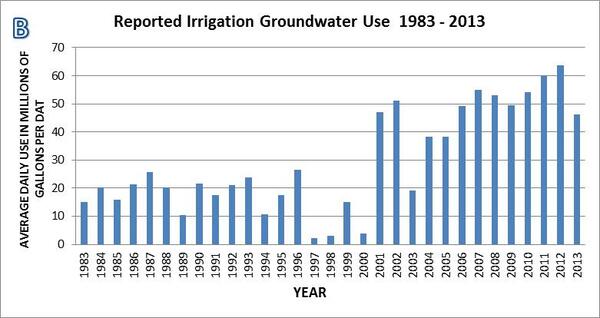
Overall, groundwater use in the SC Coastal Plain from 2004-2013 has increased slightly from about 202 million gallons per day (Mgal/d) in 2004 to an average of 209 Mgal/d from 2005 to 2013 (SCDHEC, written commun, 2015) (fig. 2A). There has been a significant increase in irrigated agriculture in SC, with much of this new water demand met by groundwater use (fig. 2B). In SC this trend is likely to continue. Potential adverse effects of the continued increase in groundwater withdrawals include groundwater level declines and reduced baseflow to streams and other surface-water bodies.
The population of SC has increased substantially from 2000 to 2014 growing from about 4.0 to about 4.6 million residents (U.S. Census Bueau, 2015). The 13-percent increase in population is not evenly distributed across the state but tends to be concentrated in the larger cities and coastal areas. Some of the water needs for this growing population are being met by groundwater use which tends to be concentrated public supply use in a few muncipalities in the SC Coastal Plain (fig. 3).
The SC Agriculture Commission is actively recruiting industrial-scale farms to locate in the Coastal Plain counties of SC (SC Commissioner of Agriculture, oral commun., March 2015) (fig. 4). These new farms will most likely use groundwater for their primary source of irrigation water and are likely to be clustered in areas with suitable soils, transportation, and labor. In addition, the Palmetto Agribusiness Council has a plan to increase the economic impact of agriculture, forestry, and allied industries from \$34 billion to \$50 billion by 2020 (Palmetto Agribusiness Council, 2015). This new agricultural activity will demand large quantities of water that will most likely be supplied primarily by groundwater. It is not known if these proposed increases in groundwater use for agricultural uses will have negative effects on groundwater levels, surface-water flows and/or other groundwater users.
Precipitation patterns are changing across the SC Coastal Plain with implications for groundwater recharge rates. Reduced precipitation rates, especially in the cooler months (November – March) could lead to lower groundwater recharge rates and groundwater levels. A study by Mizzell and others (2014) of historic precipitation trends, indicates a general decrease in precipitation in SC from 1900 to 2010 for summer rainfalls, increasing fall precipitation, and mixed increases and decreases for winter and spring. Future precipitation patterns could follow these trends.
The South Carolina Water Plan, 2nd Edition (Badr and others, 2004) states: “A comprehensive groundwater flow model of the Coastal Plain should be developed and used to predict the effects of future pumping and to determine optimal well spacings”. The proposed update to the Campbell and Coes (2010) model will provide the model described in the SC Water Plan. An updated groundwater flow model of the South Carolina Coastal Plain will benefit the State of SC by providing a tool that can be used by water-resource managers to estimate current available water resources and to assess the effects of future water use development and climate variability on available water resources. The USGS proposes to work cooperatively with the SCDNR, SCDHEC, and SC Department of Agriculture to develop an updated groundwater flow model of the South Carolina Coastal Plain.
OBJECTIVES AND SCOPE
—————————————————————————————————————————————————————
The objective of the proposed investigation is to update the groundwater flow model of the South Carolina Coastal Plain presented in Campbell and Coes, 2010. Updates to the model will include activating and rediscretizing the surficial aquifer model layer, adding recent groundwater-related data (2005-2015), refining the model grid in some areas, incorporating a more detailed representation of the Fall Line area, re-calibration, and applying the model to a series of 6 scenarios. Numerous sites have been added to the SC groundwater level monitoring network, primarily by the SCDNR and SCDHEC, since 2004 when the Campbell and Coes (2010) model was last calibrated (Harder and others, 2014; H. Gilkerson, SCDHEC, personal commun., 2015). Water-use data have been compiled by SCDHEC for 2005-2014 and will be simulated in the proposed groundwater model update. A series of 6 future scenarios will be simulated with the updated model to attempt to give some insight into how potential changes in groundwater withdrawal patterns and rates and climatic changes could affect groundwater levels and stream baseflows.
The scope of this investigation will include the South Carolina Atlantic Coastal Plain aquifers and confining units. However, to simulate model boundary conditions, the model is extended into the Georgia and North Carolina Coastal Plain. A USGS Scientific Investigations report documenting the investigation will be published during the final year of the study.
APPROACH
—————————————————————————————————————————————————————
The objectives listed above will be met during this 3-year investigation by implementation of the following 6 tasks.
Task 1: Data Acquistion
- Compile existing hydrostratigraphic data: This task will include compiling all data necessary to update the regional hydrogeologic framework at a finer scale, especially in the surficial aquifer layer of the model. Existing geologic reports and maps, subsurface data and hydrogeologic information will be assembled to refine the current hydrostratigraphy presented in Gellici and Lautier (2010). Project personnel will work closely with state agency scientists who have extensive knowledge of the proposed study area.
- Compile and interpret existing aquifer-test data: Aquifer-test data are available from several sources in the study area. Recent data from the USGS and state agencies will be collected, interpreted, and input into the model.
- Compile existing groundwater-level data: There are several sources of groundwater-level data in the study area. Existing reports, the USGS database, and SCDNR and SCDHEC will be the primary sources of historic and recent groundwater-level data collected in the area.
- Refine the existing regional hydrogeologic framework to incorporate recent data: The current hydrogeologic framework for the proposed study area will be refined, where needed, by using currently available stratigraphic and hydrogeologic data. The refined framework will use existing wells that have the required data available (geophysical logs, cores, and drill cuttings descriptions). The Fall Line area of the model will be updated to a 1:500,000 scale that is available from the SCDNR (S.C. Department of Natural Resources, 2015)
- Collect and compile water-use data: Groundwater use data from 2005 to Year 1 of the study will be acquired from SCDHEC.
Task 2: Convert Data to Various Model Inputs
- The various types of data (water use, groundwater levels, stream baseflows, perennial stream location and stage/bottom elevations, and hydrogeologic framework) will be formatted for input into the groundwater flow model. This task will be accomplished primarily with the use of geographic information system software, database software and spreadsheets. These data will be input into the graphical-use interface software for use in the groundwater flow model. These data will be archived for future use.
Task 3: Re-Configure Groundwater Flow Model
- Updating the existing groundwater flow model is a challenging and difficult task. The area simulated is very large (~70,000 mi2, with about 22,500 mi2 in SC) and contains 16 aquifers and confining units. At the time the original model was being constructed and calibrated (2004-2008), the model strained the hardware and software resources and was difficult to construct and calibrate due to large file sizes and long run times. Since then, computing resources are much improved, primarily with the 64-bit computers and software currently available. However, attempting to simulate such a large area and number of aquifers is still challenging and reducing the model cell size and increasing the number of simulated streams, rivers, and surface water bodies is anticipated to again strain the computing resources available. Attempts will be made to simulate the natural system in detail, but most likely, trade-offs will have to made to simplify the simulations and some hydrologic features (such as stream networks) will have to be reduced in detail. These decisions will be made in consultation with SCDNR Hydrologists. A recent USGS groundwater study in the Chesterfield County area (Campbell and Landmeyer, 2014) was able to produce a MODFLOW groundwater flow model with 300 x 300 ft model cells that adequately simulated groundwater – surface water interactions. This level of detail was able to use the surface-water features on a 1:24,000 scale. This 1:24,000 scale will be the first level of detail attempted with the model update but may have to be simplified to some extent to overcome computing limitations.
- The existing groundwater-flow model of the North Carolina–South Carolina Atlantic Coastal Plain (Campbell and Coes, 2010) will be updated using MODFLOW-2005 (Harbaugh, 2005), or possibly a new version of MODFLOW, MODFLOW-2015 that is under development (C. Langevin, USGS, oral commun., 2014). One of the primary modifications to the Campbell and Coes (2010) model will activate the entire surficial aquifer layer and decrease the grid-spacing of 2 x 2 miles. The new surficial aquifer grid spacing will be determined as the model construction proceeds and will be limited by available computer software and hardware resources. In addition, other model layers grid spacing may be reduced if sufficient data, such as groundwater use or groundwater levels are available for specific areas. A commercial graphical user interface will be used to enhance pre- and post-processing tasks, as well as to allow for visualization, ease of use, and updating. This modeling effort will include all of the Atlantic Coastal Plain aquifers in the study area. Boundary conditions from the Campbell and Coes (2010) model will initially be used and but may be modified to best simulate natural groundwater flow and surface-water –groundwater interaction conditions within the aquifers.
- The Campbell and Coes (2010) groundwater flow model will be modified in several important ways with new simulation capabilities. A new version of the USGS Modular Model (MODFLOW-2005), MODFLOW-NWT or MODFLOW Newton will be used in place of the original MODFLOW Layer Property Flow package. MODFLOW-NWT is a Newton-Raphson formulation for MODFLOW-2005 to improve solution of unconfined groundwater-flow problems. MODFLOW-NWT is intended for solving problems involving drying and rewetting nonlinearities of the unconfined groundwater-flow equation (Niswonger and others, 2011). The USGS MODFLOW Unstructured Grid (USG) package (Panday and others, 2013) will be used to allow a varying size model grid in the surficial model layer and possibly in other model layers. The varying model grid size will attempt to better simulate groundwater – surface water interactions within the surficial layer of the model. The Campbell and Coes (2010) model simulated only the major rivers such as the Savannah, North and South Edisto, and the Pee Dee Rivers in the inner Coastal Plain. The updated model will attempt to activate the entire surficial aquifer model layer and simulate smaller streams along with the major rivers in both the inner and outer Coastal Plain. The outer Coastal Plain surficial aquifer was simulated with specified heads in the Campbell and Coes (2010) model. These outer Coastal Plain areas will be converted to smaller, active model cells (instead of the original specified-head type cells) that will attempt to simulate groundwater – surface interactions of smaller streams.
- The boundary conditions from the Campbell and Coes (2010) model will be re-evaluated and modified as appropriate to best represent the natural hydrologic conditions. Stream networks will be included in the model in the surficial aquifer at a scale that is allowed by the computer resources. The updated groundwater-flow model will extend to natural hydrologic boundaries, such as the Fall Line to the north, the Altamaha River to the west, the James River to the east and the offshore extent of the aquifer to the southeast, to properly simulate groundwater flow. Climatic water budgets will be applied to better estimate net recharge (precipitation minus evapotranspiration minus surface runoff). The estimated net recharge may be refined during the recalibration process.
- The original downgradient (seaward) model boundaries were simulated as no-flow boundaries and there was no variable density component to these boundary conditions. The updated model will use a new MODFLOW package, the Seawater Intrusion 2 (SWI2) package (Bakker and others, 2013) that allows three-dimensional vertically integrated variable-density groundwater flow and seawater intrusion in coastal multi-aquifer systems to be simulated using MODFLOW-2005. Use of the SWI2 package will allow a more realistic simulation of the seaward aquifer boundaries than the original Campbell and Coes (2010) model.
Task 4: Re-Calibrate Model to Past and Current (Year 1) Conditions
- The groundwater flow model will be re-calibrated to the following conditions 1) predevelopment, 2) 1982, 3) 2004, and 4) Year 1 of the proposed project. The model will be calibrated with an automated parameter-estimation approach using the computer program PEST (Doherty, 2005). The objective of the calibration process is to minimize the weighted sum-of-squares differences between model-generated groundwater-level values and stream baseflows and field-measured groundwater-levels and stream baseflows. Recent (2013) groundwater age dates collected from a series of Cretaceous-age aquifer public-supply wells by the USGS National Water Quality Program will be used in the model calibration process.
Task 5: Scenarios
- A series of six scenarios will be programmed with the updated and calibrated groundwater flow model. These scenarios will be planned with the various State Agency Cooperators and designed to provide information on the possible effects of changing patterns of groundwater use and (or) changes in future precipitation rates and the subsequent effects on the groundwater levels and stream baseflows of the SC Coastal Plain.
Task 6: Report Preparation
- The updated groundwater flow model will be documented in a USGS Scientific Investigations Report (SIR) that will include all of the required descriptions of the model inputs, outputs, and scenarios along with a model archive.
Report
A USGS SIR will be published to document the updated groundwater flow model and summarize the results of the scenarios. The SIR will not have to be as detailed as the original model documentation report (Campbell and Coes, 2010) since it will describe an update to the original model.
REFERENCES
—————————————————————————————————————————————————————
Badr, A. W., Wachob, A., and Gellici, J. A., 2004, South Carolina Water Plan, 2nd Edition: South Carolina Department of Natural Resources, Land, Water and Conservation Division, 120p.
Bakker, Mark, Schaars, Frans, Hughes, J.D., Langevin, C.D., and Dausman, A.M., 2013, Documentation of the Seawater Intrusion (SWI2) Package for MODFLOW: U.S. Geological Survey Techniques and Methods, book 6, chap. A46, 47 p.,
Campbell, B.G., and Coes, A.L., eds., 2010, Groundwater availability in the Atlantic Coastal Plain of North and South Carolina: U.S. Geological Survey Professional Paper 1773, 241 p., 7 pls.
Campbell, B.G., and Landmeyer, J.E., 2014, Groundwater availability in the Crouch Branch and McQueen Branch aquifers, Chesterfield County, South Carolina, 1900–2012: U.S. Geological Survey Scientific Investigations Report 2014–5050, 68 p.,
Doherty, John, 2005, PEST, model independent parameter estimation users manual (5th ed.): Watermark Numerical Computing, 336 p
Evenson, E.J., Orndorff, R.C., Blome, C.D., Böhlke, J.K., Hershberger, P.K., Langenheim, V.E., McCabe, G.J., Morlock, S.E., Reeves, H.W., Verdin, J.P., Weyers, H.S., and Wood, T.M., 2013, U.S. Geological Survey water science strategy—Observing, understanding, predicting, and delivering water science to the Nation: U.S. Geological Survey Circular 1383–G, 49 p.
Fry, J., Xian, G., Jin, S., Dewitz, J., Homer, C., Yang, L., Barnes, C., Herold, N., and Wickham, J., 2011, Completion of the 2006 National Land Cover Database for the Conterminous United States: PE&RS, Vol. 77(9):858-864.
Gellici, J.A., and Lautier, J.C., 2010, Hydrogeologic framework of the Atlantic Coastal Plain, North and South Carolina, in Campbell, B.G., and Coes, A.L., eds., Groundwater availability in the Atlantic Coastal Plain of North and South Carolina: U.S. Geological Survey Professional Paper 1773, p. 49–162.
Harbaugh, A.W., 2005, MODFLOW-2005, The U.S. Geological Survey modular ground-water model—the ground-water flow process: U.S. Geological Survey Techniques and Methods 6-A16, variously paged.
Harder, S.V., Gawne, C.E., Gellici, J.E., and Wachob, A., 2012, Groundwater levels in South Carolina, 2006-2010: South Carolina Department of Natural Resources, Land, Water and Conservation Division, Water Resources Report 50, 154p
Harder, S.V., Gellici, J.A., and Wachob, A., 2014, South Carolina DNR Groundwater Monitoring Network Status Report: South Carolina Department of Natural Resources, Land, Water and Conservation Division, Water Resources Report 57, 86p.
Hockensmith, B. L., 2008a, Potentiometric surface of the Middendorf aquifer in South Carolina: South Carolina Department of Natural Resources, Land, Water and Conservation Division, Water Resources Report 46, 11p.
Hockensmith, 2008b, Potentiometric surface of the Black Creek aquifer in South Carolina: South Carolina Department of Natural Resources, Land, Water and Conservation Division, Water Resources Report 47, 10p.
Hockensmith, B. L., Wachob, A., Howard, C. S., and Koch, E., 2013a, Potentiometric Surface of the Middendorf Aquifer in South Carolina, November 2011: South Carolina Department of Natural Resources, Land, Water and Conservation Division, Water Resources Report 54, 1 plate.
Hockensmith, B. L., Wachob, A., Howard, C. S., and Koch, E., 2013b, Potentiometric Surface of the Black Creek Aquifer in South Carolina, November 2011: South Carolina Department of Natural Resources, Land, Water and Conservation Division, Water Resources Report 55, 1 plate.
Mizzell, H., Malsick, M., and Abramyan, I., 2014, South Carolina’s climate report card: understanding South Carolina’s climate trends and variability: Journal of South Carolina Water Resources, Vol. 1, no. 1, p. 4-9.
Niswonger, R.G., Panday, Sorab, and Ibaraki, Motomu, 2011, MODFLOW-NWT, A Newton formulation for MODFLOW-2005: U.S. Geological Survey Techniques and Methods 6-A37, 44 p.
Palmetto Agribusiness Council, 2015, 50 by 20 – A Ten Year Goal for South Carolina Agriculture
Panday, Sorab, Langevin, C.D., Niswonger, R.G., Ibaraki, Motomu, and Hughes, J.D., 2013, MODFLOW-USG version 1: An unstructured grid version of MODFLOW for simulating groundwater flow and tightly coupled processes using a control volume finite-difference formulation: U.S. Geological Survey Techniques and Methods, book 6, chap. A45, 66 p.
South Carolina Department of Health and Environmental Control, 2006, Groundwater Use and ReportingR.61-113
South Carolina Department of Natural Resources, 2015, Geographic Information System Data: web page accessed 4-27-2015
U.S. Census Bureau, 2015, Population Estimates: accessed on April 24, 2015
U.S. Geological Survey, 2011, Water Resources Discipline Information Memorandum No. 2011.01 Priority Issues for the Cooperative Water Program, Fiscal Year 2011/12: accessed on May 5, 2016
U.S. Geological Survey, 2015, Groundwater Watch web pages
Release Date: 12/13/2016