
The Issue:
Management efforts on the lower Green River to reduce flood hazards and improve habitat conditions are inherently interconnected with sediment transport and channel change dynamics. Those dynamics are, in turn, driven by a mix of interacting geologic, anthropogenic, and hydrologic factors. However, there have been no recent watershed-scale analyses of sediment dynamics in the Green River and their underlying drivers.
How USGS will help:
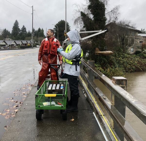
The USGS will be monitoring suspended-sediment loads for two years at four locations along the Green River downstream of Howard Hanson Dam, and one site on a major tributary (Big Soos Creek). Limited bed load sampling will also be conducted on the main stem near Auburn. Monitoring data will be supplemented by analyses of historical channel change based on existing lidar, cross-section, and aerial imagery datasets. These results will be synthesized in an interpretive report describing the modern sediment budget of the Green River, and the factors that influence sediment dynamics in the watershed.
Problem
Management efforts on the Green River to reduce flood hazards and improve habitat conditions are inherently interconnected with sediment transport and channel change dynamics. Those dynamics are, in turn, driven by a mix of interacting geologic, anthropogenic, and hydrologic factors. However, at present, there have been no systematic, watershed-scale analyses of modern sediment dynamics and their underlying drivers. The lack of such an integrated assessment makes it difficult to assess the viability of individual management actions and develop an integrated, watershed-scale river management plan.
Objectives
The objective of this work is to better understand the contemporary sources and sinks of sediment in the lower and middle reaches of the Green River and, to the degree possible, the historical context (both geologic and human) influencing contemporary sediment dynamics. These objectives will be met through a combination of contemporary suspended sediment monitoring, analyses of recent and historical channel change, and syntheses of existing datasets and studies. This work is focused on the lower and middle extents of the Green River, encompassing the contributing area downstream of Howard Hanson Dam.
Relevance and Benefits
This work will help King County to better understand and manage sediment-related concerns in the lower Green River. In particular, this work will help inform selection and design of river restoration and flood protection measures in the lower Green River watershed. This work will also continue to build regional understandings of sediment transport and channel change in sediment-rich western Washington rivers.
By providing local stakeholders with timely and relevant synthesis of complex data, this work aligns with the USGS mission to “engage with stakeholders and decision makers who rely on our science to carry out actions to mitigate riverine and coastal flooding, perform ecosystem restoration, [and] manage inland freshwater fisheries…” (USGS, 2021).
Approach
This work will consist of two primary and related data collection and analysis efforts. The first involves two years of suspended sediment monitoring at five locations in the lower Green River watershed. The second will be a synthesis of recent and historical channel change, using a combination of modern repeat aerial lidar, historical cross section surveys, and geomorphic change inferred from USGS stream gages.
Results from both efforts will be used to describe major sediment sources and sinks in the lower Green River watershed and any systematic trends in channel elevation. These results will be combined with prior geologic and geomorphic datasets and studies to provide an updated understanding of sediment dynamics in the lower Green River watershed.
Title
Explore the project map
Click the points on the map the five sediment monitoring locations included in this study. Click "Learn more" to get data.
The Issue:
Management efforts on the lower Green River to reduce flood hazards and improve habitat conditions are inherently interconnected with sediment transport and channel change dynamics. Those dynamics are, in turn, driven by a mix of interacting geologic, anthropogenic, and hydrologic factors. However, there have been no recent watershed-scale analyses of sediment dynamics in the Green River and their underlying drivers.
How USGS will help:
The USGS will be monitoring suspended-sediment loads for two years at four locations along the Green River downstream of Howard Hanson Dam, and one site on a major tributary (Big Soos Creek). Limited bed load sampling will also be conducted on the main stem near Auburn. Monitoring data will be supplemented by analyses of historical channel change based on existing lidar, cross-section, and aerial imagery datasets. These results will be synthesized in an interpretive report describing the modern sediment budget of the Green River, and the factors that influence sediment dynamics in the watershed.
Problem
Management efforts on the Green River to reduce flood hazards and improve habitat conditions are inherently interconnected with sediment transport and channel change dynamics. Those dynamics are, in turn, driven by a mix of interacting geologic, anthropogenic, and hydrologic factors. However, at present, there have been no systematic, watershed-scale analyses of modern sediment dynamics and their underlying drivers. The lack of such an integrated assessment makes it difficult to assess the viability of individual management actions and develop an integrated, watershed-scale river management plan.
Objectives
The objective of this work is to better understand the contemporary sources and sinks of sediment in the lower and middle reaches of the Green River and, to the degree possible, the historical context (both geologic and human) influencing contemporary sediment dynamics. These objectives will be met through a combination of contemporary suspended sediment monitoring, analyses of recent and historical channel change, and syntheses of existing datasets and studies. This work is focused on the lower and middle extents of the Green River, encompassing the contributing area downstream of Howard Hanson Dam.
Relevance and Benefits
This work will help King County to better understand and manage sediment-related concerns in the lower Green River. In particular, this work will help inform selection and design of river restoration and flood protection measures in the lower Green River watershed. This work will also continue to build regional understandings of sediment transport and channel change in sediment-rich western Washington rivers.
By providing local stakeholders with timely and relevant synthesis of complex data, this work aligns with the USGS mission to “engage with stakeholders and decision makers who rely on our science to carry out actions to mitigate riverine and coastal flooding, perform ecosystem restoration, [and] manage inland freshwater fisheries…” (USGS, 2021).
Approach
This work will consist of two primary and related data collection and analysis efforts. The first involves two years of suspended sediment monitoring at five locations in the lower Green River watershed. The second will be a synthesis of recent and historical channel change, using a combination of modern repeat aerial lidar, historical cross section surveys, and geomorphic change inferred from USGS stream gages.
Results from both efforts will be used to describe major sediment sources and sinks in the lower Green River watershed and any systematic trends in channel elevation. These results will be combined with prior geologic and geomorphic datasets and studies to provide an updated understanding of sediment dynamics in the lower Green River watershed.
Title
Explore the project map
Click the points on the map the five sediment monitoring locations included in this study. Click "Learn more" to get data.