
Scott W Anderson
Scott Anderson is a hydrologist and geomorphologist in the Watersheds and Fluvial Systems Section at the Washington Water Science Center.
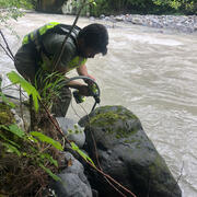
My work has focused on sediment transport and channel change in rivers of the Pacific Northwest, combining direct sediment sampling, high-resolution topographic differencing, and historical records to understand reach- to watershed-scale sediment dynamics. Much of this work has revolved around understanding how geologic history, human impacts, and contemporary climate interact to influence those sediment dynamic, and how they, in turn, influence flood hazards, habitat, and restoration efforts.
Science and Products
Assessment of bedload monitoring methods
The Issue: The Washington State Department of Transportation (WSDOT) maintains many roads and bridges that either abut or cross dynamic gravel-bedded rivers. The design and maintenance of these structures often requires assessing sediment transport and river channel dynamics. However, the transport of sand and gravel as bedload, and the channel change that results from that transport, remains...
Testing non-contact discharge measurement methods in the Nooksack River
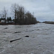
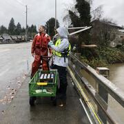
The Issue: The North Cedarville streamgage on the Nooksack River (USGS 12210700) is critical for flood monitoring and hazard assessments. However, making discharge measurements at high flows, which are necessary to maintain an accurate stage-discharge relation at this dynamic site, is complicated by transport of woody debris and difficulties detecting the bed using traditional acoustic doppler...
Green River Sediment Monitoring
The Issue: Management efforts on the lower Green River to reduce flood hazards and improve habitat conditions are inherently interconnected with sediment transport and channel change dynamics. Those dynamics are, in turn, driven by a mix of interacting geologic, anthropogenic, and hydrologic factors. However, there have been no recent watershed-scale analyses of sediment dynamics in the Green...

Hoh geomorphology
The Issue: Glaciers in the Hoh River watershed are expected to largely disappear by 2050, while flooding is expected to become more intense. Understanding if or how this will impact sediment transport and channel change in the watershed is relevant for salmon habitat, restoration efforts, and flood hazard management. However, there is relatively little information about historical channel...

Nooksack geomorphology
The Issue: Changes in channel geometry in the Nooksack River can reduce flood conveyance capacity, and so increase local flood hazards. Near Everson, WA, sand and gravel accumulations have increased the likelihood that major floods will spill overbank, sending water north over a low drainage divide where it may cause substantial damage to communities in both Washington and British Columbia. Major...

Channel Change and Sediment Transport in the Puyallup River Watershed
The Issue: Sediment loads in the Puyallup River and its major tributaries, the White River and Carbon River, are high and river channels are dynamic. While there is a relatively rich history of sediment transport and channel change studies in the Puyallup River and its tributaries, there has not been an integrated assessment of channel-elevation trends in nearly a decade. This lack of up-to-date...
Chehalis Watershed Suspended Sediment Monitoring
The USGS monitored sediment loads in the Chehalis River and its major tributaries, allowing comparisons with historical monitoring. As a result, we now have a better understanding of modern sediment loads and how those loads have changed since the 1960s in response to improved land use practices. This information helps the U.S. Army Corps of Engineers maintain shipping access in Grays Harbor.

Channel change monitoring following the Pilchuck Dam removal
The issue: In the summer of 2020, the Pilchuck Dam will be removed, allowing salmon access to the upper third of the Pilchuck River watershed for the first time in over a century. This removal will be associated with a short period increased sediment delivery, as the river re-works material trapped behind the dam. While the volume of impounded sediment is small and major changes in the downstream...

Coarse sediment delivery and routing in the White River
The Issue: Ongoing channel aggradation has reduced flow conveyance along the lower White River, increasing the flood risk in urban-suburban areas. A refined understanding of the delivery, transport and deposition of sediment in the White River, and how those processes may be influenced by climate and existing dam operations, is necessary in order to plan for future flood hazard in the lower White...

Sediment Transport in Vance Creek
The Issue: Streamflow in the lower 3.6 miles of the gravel-bedded Vance Creek often goes subsurface in the summer, limiting potential utilization by fish. There is an interest in stream restoration projects that might improve low-flow habitat conditions and connectivity, but their design and implementation are limited by a lack of knowledge about sediment transport conditions in the reach. How...

Sauk River Sediment
Fine-grained sediments in the lower reach of the Sauk River are adversely affecting the health and spawning of Chinook salmon. Climate change and forestry practices have been proposed as suspected causes of a reported increase in sediment loading to the river. To determine the amount and timing of suspended-sediment loading to the river and possible connections to adverse effects on Chinook salmon...

SR 530 Slide
In the immediate aftermath of the SR530 Landslide, the USGS supported first responders and decision-makers as a key member of the collaborative effort to monitor the stability of the landslide deposit and the associated impoundment of the North Fork Stillaguamish River during rescue operations. With the initial disaster response now over, longer-term questions have arisen regarding the stability...
Science and Products
Assessment of bedload monitoring methods
The Issue: The Washington State Department of Transportation (WSDOT) maintains many roads and bridges that either abut or cross dynamic gravel-bedded rivers. The design and maintenance of these structures often requires assessing sediment transport and river channel dynamics. However, the transport of sand and gravel as bedload, and the channel change that results from that transport, remains...
Testing non-contact discharge measurement methods in the Nooksack River
The Issue: The North Cedarville streamgage on the Nooksack River (USGS 12210700) is critical for flood monitoring and hazard assessments. However, making discharge measurements at high flows, which are necessary to maintain an accurate stage-discharge relation at this dynamic site, is complicated by transport of woody debris and difficulties detecting the bed using traditional acoustic doppler...
Green River Sediment Monitoring
The Issue: Management efforts on the lower Green River to reduce flood hazards and improve habitat conditions are inherently interconnected with sediment transport and channel change dynamics. Those dynamics are, in turn, driven by a mix of interacting geologic, anthropogenic, and hydrologic factors. However, there have been no recent watershed-scale analyses of sediment dynamics in the Green...
Hoh geomorphology
The Issue: Glaciers in the Hoh River watershed are expected to largely disappear by 2050, while flooding is expected to become more intense. Understanding if or how this will impact sediment transport and channel change in the watershed is relevant for salmon habitat, restoration efforts, and flood hazard management. However, there is relatively little information about historical channel...
Nooksack geomorphology
The Issue: Changes in channel geometry in the Nooksack River can reduce flood conveyance capacity, and so increase local flood hazards. Near Everson, WA, sand and gravel accumulations have increased the likelihood that major floods will spill overbank, sending water north over a low drainage divide where it may cause substantial damage to communities in both Washington and British Columbia. Major...
Channel Change and Sediment Transport in the Puyallup River Watershed
The Issue: Sediment loads in the Puyallup River and its major tributaries, the White River and Carbon River, are high and river channels are dynamic. While there is a relatively rich history of sediment transport and channel change studies in the Puyallup River and its tributaries, there has not been an integrated assessment of channel-elevation trends in nearly a decade. This lack of up-to-date...
Chehalis Watershed Suspended Sediment Monitoring
The USGS monitored sediment loads in the Chehalis River and its major tributaries, allowing comparisons with historical monitoring. As a result, we now have a better understanding of modern sediment loads and how those loads have changed since the 1960s in response to improved land use practices. This information helps the U.S. Army Corps of Engineers maintain shipping access in Grays Harbor.
Channel change monitoring following the Pilchuck Dam removal
The issue: In the summer of 2020, the Pilchuck Dam will be removed, allowing salmon access to the upper third of the Pilchuck River watershed for the first time in over a century. This removal will be associated with a short period increased sediment delivery, as the river re-works material trapped behind the dam. While the volume of impounded sediment is small and major changes in the downstream...
Coarse sediment delivery and routing in the White River
The Issue: Ongoing channel aggradation has reduced flow conveyance along the lower White River, increasing the flood risk in urban-suburban areas. A refined understanding of the delivery, transport and deposition of sediment in the White River, and how those processes may be influenced by climate and existing dam operations, is necessary in order to plan for future flood hazard in the lower White...
Sediment Transport in Vance Creek
The Issue: Streamflow in the lower 3.6 miles of the gravel-bedded Vance Creek often goes subsurface in the summer, limiting potential utilization by fish. There is an interest in stream restoration projects that might improve low-flow habitat conditions and connectivity, but their design and implementation are limited by a lack of knowledge about sediment transport conditions in the reach. How...
Sauk River Sediment
Fine-grained sediments in the lower reach of the Sauk River are adversely affecting the health and spawning of Chinook salmon. Climate change and forestry practices have been proposed as suspected causes of a reported increase in sediment loading to the river. To determine the amount and timing of suspended-sediment loading to the river and possible connections to adverse effects on Chinook salmon...
SR 530 Slide
In the immediate aftermath of the SR530 Landslide, the USGS supported first responders and decision-makers as a key member of the collaborative effort to monitor the stability of the landslide deposit and the associated impoundment of the North Fork Stillaguamish River during rescue operations. With the initial disaster response now over, longer-term questions have arisen regarding the stability...