
Louisiana Barrier Island Habitat Mapping and Change Assessment
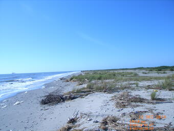
Barrier islands provide numerous invaluable ecosystem goods and services including storm protection and erosion control for the mainland, habitat for fish and wildlife, salinity regulation in estuaries, carbon sequestration in marshes, recreation, and tourism. These islands are dynamic environments due to their position at the land-sea interface. Storms, wave energy, tides, currents, and relative sea-level rise are powerful forces that shape barrier island geomorphology and habitats.
The Science Issue and Relevance: Barrier islands provide numerous invaluable ecosystem goods and services including storm protection and erosion control for the mainland, habitat for fish and wildlife, salinity regulation in estuaries, carbon sequestration in marshes, recreation, and tourism. These islands are dynamic environments due to their position at the land-sea interface. Storms, wave energy, tides, currents, and relative sea-level rise are powerful forces that shape barrier island geomorphology and habitats.
The Barrier Island Comprehensive Monitoring (BICM) program was developed by Louisiana’s Coastal Protection Restoration Authority (CPRA) and is implemented as a component of the System-Wide Assessment and Monitoring Program (SWAMP). The BICM program uses both historical and contemporary data collections to assess and monitor changes in the aerial and subaqueous extent of islands, habitat types, sediment texture and geotechnical properties, environmental processes, and vegetation composition. Examples of BICM datasets include still and video aerial photography for documenting shoreline changes, shoreline positions, habitat mapping, land change analyses, aerial topographic light detection and ranging (lidar) surveys, single-beam and swath bathymetry surveys, and sediment grab samples. The U.S. Geological Survey’s Wetland and Aquatic Research Center provides geospatial support to the BICM program for mapping barrier island habitats and assessing habitat change over time.
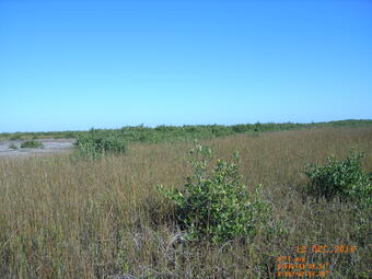
Methodology for Addressing the Issue: Habitat maps will be generated from high resolution orthophotography using object-based analyses in the Trimble eCognition software (Westminster, CO) for 2021 for numerous coastal reaches in Louisiana. This software allows for a variety of data (e.g., aerial imagery, lidar, bathymetry, etc.) to be integrated into the habitat classification process. The first step of object-based classification is to segment imagery into individual objects based on spatial and spectral similarities. Next, rather than classifying individual pixels, image objects are classified using object-level statistics. Object-based classification typically outperforms pixel-based classifications when used to classify high resolution orthophotography and has been used by numerous researchers to create barrier island habitat maps. The BICM program has developed two habitat classification schemes, which include a detailed 15-class and a general eight-class habitat scheme. The detailed scheme was developed specifically for this habitat mapping effort and builds off the general scheme used in previous BICM habitat mapping efforts. The additional classes developed in the detailed scheme are primarily used to further delineate various dune habitats, separate marsh and mangrove, and distinguish between beach and unvegetated barrier flat habitats. To ensure that we can compare between this effort and previous BICM map products, we will crosswalk the detailed classes to the general habitat classes used for past products. Spatial change analyses will be conducted between previously developed BICM habitat maps from 2015/16 and the maps produced through this effort.
Future Steps: The habitat maps and change assessment products produced through this project will be published as a USGS data release. Additionally, the USGS Wetland and Aquatic Research Center’s Advanced Application Team will add new products to the BICM Habitat Reporting Tool, a custom, web-based reporting tool that will allow for visualization of habitat maps and change statistics for various reporting boundaries.

Barrier islands provide numerous invaluable ecosystem goods and services including storm protection and erosion control for the mainland, habitat for fish and wildlife, salinity regulation in estuaries, carbon sequestration in marshes, recreation, and tourism. These islands are dynamic environments due to their position at the land-sea interface. Storms, wave energy, tides, currents, and relative sea-level rise are powerful forces that shape barrier island geomorphology and habitats.
The Science Issue and Relevance: Barrier islands provide numerous invaluable ecosystem goods and services including storm protection and erosion control for the mainland, habitat for fish and wildlife, salinity regulation in estuaries, carbon sequestration in marshes, recreation, and tourism. These islands are dynamic environments due to their position at the land-sea interface. Storms, wave energy, tides, currents, and relative sea-level rise are powerful forces that shape barrier island geomorphology and habitats.
The Barrier Island Comprehensive Monitoring (BICM) program was developed by Louisiana’s Coastal Protection Restoration Authority (CPRA) and is implemented as a component of the System-Wide Assessment and Monitoring Program (SWAMP). The BICM program uses both historical and contemporary data collections to assess and monitor changes in the aerial and subaqueous extent of islands, habitat types, sediment texture and geotechnical properties, environmental processes, and vegetation composition. Examples of BICM datasets include still and video aerial photography for documenting shoreline changes, shoreline positions, habitat mapping, land change analyses, aerial topographic light detection and ranging (lidar) surveys, single-beam and swath bathymetry surveys, and sediment grab samples. The U.S. Geological Survey’s Wetland and Aquatic Research Center provides geospatial support to the BICM program for mapping barrier island habitats and assessing habitat change over time.
Methodology for Addressing the Issue: Habitat maps will be generated from high resolution orthophotography using object-based analyses in the Trimble eCognition software (Westminster, CO) for 2021 for numerous coastal reaches in Louisiana. This software allows for a variety of data (e.g., aerial imagery, lidar, bathymetry, etc.) to be integrated into the habitat classification process. The first step of object-based classification is to segment imagery into individual objects based on spatial and spectral similarities. Next, rather than classifying individual pixels, image objects are classified using object-level statistics. Object-based classification typically outperforms pixel-based classifications when used to classify high resolution orthophotography and has been used by numerous researchers to create barrier island habitat maps. The BICM program has developed two habitat classification schemes, which include a detailed 15-class and a general eight-class habitat scheme. The detailed scheme was developed specifically for this habitat mapping effort and builds off the general scheme used in previous BICM habitat mapping efforts. The additional classes developed in the detailed scheme are primarily used to further delineate various dune habitats, separate marsh and mangrove, and distinguish between beach and unvegetated barrier flat habitats. To ensure that we can compare between this effort and previous BICM map products, we will crosswalk the detailed classes to the general habitat classes used for past products. Spatial change analyses will be conducted between previously developed BICM habitat maps from 2015/16 and the maps produced through this effort.
Future Steps: The habitat maps and change assessment products produced through this project will be published as a USGS data release. Additionally, the USGS Wetland and Aquatic Research Center’s Advanced Application Team will add new products to the BICM Habitat Reporting Tool, a custom, web-based reporting tool that will allow for visualization of habitat maps and change statistics for various reporting boundaries.