Spatial Analysis of Coastal Wetlands Planning, Protection and Restoration Act Projects
As the first federally mandated restoration program, Louisiana enacted the Coastal Wetlands Planning, Protection and Restoration Act (CWPPRA) to address Louisiana’s land loss crisis.

The Science Issue and Relevance: Louisiana enacted the first federally mandated restoration program known as Coastal Wetlands Planning, Protection and Restoration Act (CWPPRA) to address Louisiana’s land loss crisis. Between 1990 and 2021, the CWPPRA program has constructed 113 projects; currently, 15 projects are being constructed, and 30 are in engineering and design. These projects use a variety of restoration techniques and vary in size from small barrier island vegetation planting projects to large diversions of freshwater and sediments. The Coastwide Reference Monitoring System (CRMS) is one component of the CWPPRA restoration monitoring program and was designed to monitor the effectiveness of restoration actions at multiple spatial scales from the site level to the influence of projects on the entire coastal landscape. This network of 390 monitoring sites spans the coast through all wetland types. Restoration project effectiveness is assessed using many data types including hydrologic, ecologic, and spatial data sets. One component of project evaluation is the change in land and water composition coast-wide both within restoration project boundaries and within CRMS sites.
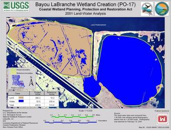
Methodology for Addressing the Issue: USGS WARC geographers maintain and utilize various databases and data layers to analyze the success and effectiveness of these restoration efforts in Louisiana. Land-water datasets are created to assess the land change in areas of interest for restoration planning and assessment throughout the Louisiana coastal zone. Wetland habitat classification datasets are also occasionally created. Aerial photography, which is generally flown every three years, is used to determine change at a finer scale and for specific applications, i.e., shoreline change analysis. The CRMS uses the land change assessment as a landscape indicator in the reporting feature.

Future Steps: In addition to the programmatic obligations, CWPPRA/CRMS geospatial datasets are used by USGS to support modeling, scientific research, and web-tool development.
As the first federally mandated restoration program, Louisiana enacted the Coastal Wetlands Planning, Protection and Restoration Act (CWPPRA) to address Louisiana’s land loss crisis.

The Science Issue and Relevance: Louisiana enacted the first federally mandated restoration program known as Coastal Wetlands Planning, Protection and Restoration Act (CWPPRA) to address Louisiana’s land loss crisis. Between 1990 and 2021, the CWPPRA program has constructed 113 projects; currently, 15 projects are being constructed, and 30 are in engineering and design. These projects use a variety of restoration techniques and vary in size from small barrier island vegetation planting projects to large diversions of freshwater and sediments. The Coastwide Reference Monitoring System (CRMS) is one component of the CWPPRA restoration monitoring program and was designed to monitor the effectiveness of restoration actions at multiple spatial scales from the site level to the influence of projects on the entire coastal landscape. This network of 390 monitoring sites spans the coast through all wetland types. Restoration project effectiveness is assessed using many data types including hydrologic, ecologic, and spatial data sets. One component of project evaluation is the change in land and water composition coast-wide both within restoration project boundaries and within CRMS sites.
Methodology for Addressing the Issue: USGS WARC geographers maintain and utilize various databases and data layers to analyze the success and effectiveness of these restoration efforts in Louisiana. Land-water datasets are created to assess the land change in areas of interest for restoration planning and assessment throughout the Louisiana coastal zone. Wetland habitat classification datasets are also occasionally created. Aerial photography, which is generally flown every three years, is used to determine change at a finer scale and for specific applications, i.e., shoreline change analysis. The CRMS uses the land change assessment as a landscape indicator in the reporting feature.

Future Steps: In addition to the programmatic obligations, CWPPRA/CRMS geospatial datasets are used by USGS to support modeling, scientific research, and web-tool development.

