
Use of Remote Sensing Data to Quantify Bird and Bat Distributions and Inform Migratory Bird Conservation Efforts
Three federal wildlife refuge complexes on the upper Texas coast include portions of the Columbia Bottomlands and other forests that are important for migratory birds and possibly bats: Texas Mid-Coast, Trinity River, and Chenier Plain.

The Science Issue and Relevance: The Columbia Bottomlands, a coastal live oak forest on the upper Texas coast, once covered over 283,280 ha in the San Bernard, Brazos, and Colorado River floodplains. Although less than 25% remains today as hundreds of forest patches, the Columbia Bottomlands is the largest coastal forest along the northwestern Gulf. This habitat type supports an estimated 29 million migrating landbirds annually. In addition, studies in east Texas suggest that up to eight bat species including two of federal concern might occur in these bottomland hardwoods. Three federal wildlife refuge complexes on the upper Texas coast include portions of the Columbia Bottomlands and other forests that are important for migratory birds and possibly bats: Texas Mid-Coast, Trinity River, and Chenier Plain. All are actively expanding their boundaries and refuge biologists seek data that will help them identify migratory landbird stopover locations and significant bat roosting sites. The data produced by this project will be used to inform their habitat conservation decisions.
Methodology for Addressing the Issue: Using weather surveillance radar data, we are identifying stopover habitats within 70 km of radar stations located in Lake Charles, Louisiana and Houston, Texas. We are analyzing data for spring (March 1 – May 31) and fall (August 1 – October 31) migrations in 2013 – 2015 and will select sample dates by screening radar data collected near evening civil twilight at the lowest radar tilt angle. Radar data collected on nights with precipitation, anomalous propagation, and clutter will be eliminated from further analyses. For the remaining data, we will estimate mean target air speed to identify bird-dominated nights (mean target airspeed greater than 5 m/s). Reflectivity data for each bird-dominated night will be interpolated to the sun elevation angle that corresponds to the timing of peak evening exodus (i.e., highest rate of change in reflectivity as birds leave stopover habitat). The data will be combined with an existing 5-year dataset (2008 – 2012), and then a multi-year geometric mean reflectivity will be calculated for spring (7-yr mean) and fall (8-yr mean). We will measure landscape metrics thought to be important to transient migrant landbirds, calculate statistical models of bird-habitat relations, and predict landbird distributions within 100 km of the Lake Charles, Louisiana and Houston, Texas radars.
Future Steps: Future research could include the use of radar data to determine the distribution of waterbird colonies and bat roost sites along the upper Texas coast.
Three federal wildlife refuge complexes on the upper Texas coast include portions of the Columbia Bottomlands and other forests that are important for migratory birds and possibly bats: Texas Mid-Coast, Trinity River, and Chenier Plain.
The Science Issue and Relevance: The Columbia Bottomlands, a coastal live oak forest on the upper Texas coast, once covered over 283,280 ha in the San Bernard, Brazos, and Colorado River floodplains. Although less than 25% remains today as hundreds of forest patches, the Columbia Bottomlands is the largest coastal forest along the northwestern Gulf. This habitat type supports an estimated 29 million migrating landbirds annually. In addition, studies in east Texas suggest that up to eight bat species including two of federal concern might occur in these bottomland hardwoods. Three federal wildlife refuge complexes on the upper Texas coast include portions of the Columbia Bottomlands and other forests that are important for migratory birds and possibly bats: Texas Mid-Coast, Trinity River, and Chenier Plain. All are actively expanding their boundaries and refuge biologists seek data that will help them identify migratory landbird stopover locations and significant bat roosting sites. The data produced by this project will be used to inform their habitat conservation decisions.
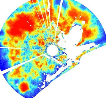
Methodology for Addressing the Issue: Using weather surveillance radar data, we are identifying stopover habitats within 70 km of radar stations located in Lake Charles, Louisiana and Houston, Texas. We are analyzing data for spring (March 1 – May 31) and fall (August 1 – October 31) migrations in 2013 – 2015 and will select sample dates by screening radar data collected near evening civil twilight at the lowest radar tilt angle. Radar data collected on nights with precipitation, anomalous propagation, and clutter will be eliminated from further analyses. For the remaining data, we will estimate mean target air speed to identify bird-dominated nights (mean target airspeed greater than 5 m/s). Reflectivity data for each bird-dominated night will be interpolated to the sun elevation angle that corresponds to the timing of peak evening exodus (i.e., highest rate of change in reflectivity as birds leave stopover habitat). The data will be combined with an existing 5-year dataset (2008 – 2012), and then a multi-year geometric mean reflectivity will be calculated for spring (7-yr mean) and fall (8-yr mean). We will measure landscape metrics thought to be important to transient migrant landbirds, calculate statistical models of bird-habitat relations, and predict landbird distributions within 100 km of the Lake Charles, Louisiana and Houston, Texas radars.
Future Steps: Future research could include the use of radar data to determine the distribution of waterbird colonies and bat roost sites along the upper Texas coast.